1970s Maps of Highfill, Arkansas
Explore 4 historic maps of Highfill from the 1970s. These maps offer a rare glimpse into what life looked like during the 1970s — showing old roads, neighborhoods, homes, and landmarks that have changed or disappeared over time.
Whether you're researching your family's past, planning a metal detecting trip, or studying how Highfill's landscape evolved across the 1970s, these high-resolution maps are a powerful tool for exploring the history of this region.
- Focus on a specific era: All maps on this page are from the 1970s, giving you a focused view of this time period.
- See what’s changed: Compare century-old streets, trails, and buildings to today's modern landscape using overlays and satellite layers.
- Research with precision: Use these maps for genealogy, historical research, land use analysis, or educational projects.
- View, download, or print: Maps are fully viewable online in high resolution, and can be downloaded or printed for your own records.
Start exploring Highfill's history through authentic maps from the 1970s. This is your window into the past.
Highfill, AR maps
(4)- 1970 Map of Robinson, 1972 Print
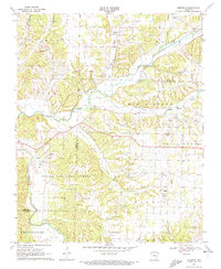 1970 Robinson1972 Print · USGSThe rural landscapes of Washington and Benton Counties are captured here in the early 1970s. Trace the history of country congregations and local research at White Oak Ch, Thornsberry Ch, and the University of Arkansas Agricultural Experiment Station.3 unique versions available
 - 1971 Map of Centerton, 1973 Print
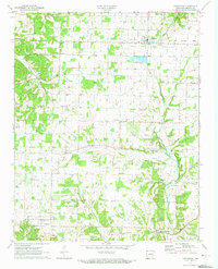 1971 Centerton1973 Print · USGSNorthwest Arkansas in the early seventies was a patchwork of family farms and small rural hubs. Researchers can trace ancestral locations through numerous family-named sites like Gamble Cem, Sunshine Sch, and the community of Mason Valley.3 unique versions available
 - 1971 Map of Gentry, 1973 Print
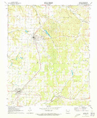 1971 Gentry1973 Print · USGSBenton County agriculture and rail transit converge in the early 1970s as the Kansas City Southern links Decatur and Gentry. Researchers can trace local roots at Gentry Cem or locate rural landmarks like Midway Ch and Springtown.2 unique versions available
 - 1979 Map of Fayetteville, 1980 Print
 1979 Fayetteville1980 Print · USGSNorthwest Arkansas and the tristate corner show a booming corridor of rail-linked towns and highland forests in the late seventies. Researchers can trace historic landmarks like Pea Ridge National Military Park, the Frisco RR, and the University of Arkansas.2 unique versions available
End of results
Showing maps 1-4 of 4
Top cities near Highfill
- Fayetteville historical maps
- Springdale historical maps
- Rogers historical maps
- Bentonville historical maps
- Bella Vista historical maps
- Centerton historical maps
See more
Top neighborhoods of Highfill
Frequently asked questions
- What are the different types of historical maps available for Highfill?
- What is the oldest map of Highfill?
- Where can I purchase historical maps of Highfill for my home or office?
- Where can I download high-res historical maps of Highfill?
- Are there historical topographic maps available for Highfill?
- Is there historical aerial imagery available for Highfill?
- Where are historical maps of Highfill sourced from?