1990s Maps of Conway County, Arkansas
Explore 15 historic maps of Conway County from the 1990s. These maps offer a rare glimpse into what life looked like during the 1990s — showing old roads, neighborhoods, homes, and landmarks that have changed or disappeared over time.
Whether you're researching your family's past, planning a metal detecting trip, or studying how Conway County's landscape evolved across the 1990s, these high-resolution maps are a powerful tool for exploring the history of this region.
- Focus on a specific era: All maps on this page are from the 1990s, giving you a focused view of this time period.
- See what’s changed: Compare century-old streets, trails, and buildings to today's modern landscape using overlays and satellite layers.
- Research with precision: Use these maps for genealogy, historical research, land use analysis, or educational projects.
- View, download, or print: Maps are fully viewable online in high resolution, and can be downloaded or printed for your own records.
Start exploring Conway County's history through authentic maps from the 1990s. This is your window into the past.
Conway County, AR maps
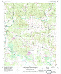
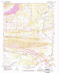
(15)- 1990 Map of Solgohachia, 1995 Print
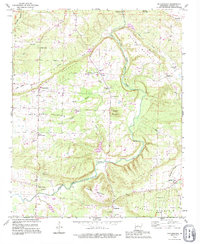 1990 Solgohachia1995 Print · USGSThe rural uplands of Conway County are captured here in the 1990s, revealing a landscape defined by creeks and ridge-top settlements. Researchers can locate numerous family-named landmarks and historical sites including St Marys Cem, Wesley Chapel, and Saint Vincent.
 - 1990 Map of Houston, 1995 Print
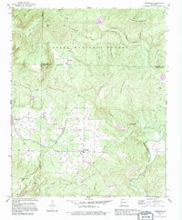
 1990 Houston1995 Print · USGSHouston and the Arkansas River valley are captured here in the early nineties, showing a landscape shaped by river bottomlands and mountain ridges. Researchers can trace family history through sites like Leach Cem or explore the geography of Sandtown Bottoms and Toms Mountain.
 - 1990 Map of Jerusalem, 1995 Print
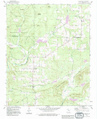
 1990 Jerusalem1995 Print · USGSThe Arkansas Ozark foothills are captured here in the 1990s as the community of Jerusalem borders the national forest. Genealogists can trace family roots through numerous upland landmarks including Thompson Chapel, Cato Cem, and the high-altitude settlement of Stumptoe.
 - 1990 Map of Cleveland, 1995 Print
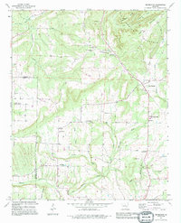
 1990 Cleveland1995 Print · USGSCentral Arkansas rural life in the 1990s is captured here along the Van Buren and Conway County line. Genealogists can trace family roots at Upchurch Cem, Moores Chapel, and the old Center School near the community of Cleveland.
 - 1990 Map of Springfield, 1995 Print
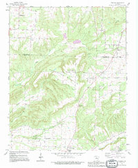
 1990 Springfield1995 Print · USGSSpringfield and the surrounding Arkansas hills are captured here in the 1990s, showcasing a landscape of isolated ridges and historic community hubs. Researchers can locate family landmarks such as Kilgore Cem, trace the Boundary Treaty Line, or explore the rural center of Birdtown.
 - 1990 Map of Morrilton East, 1995 Print
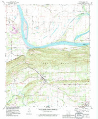
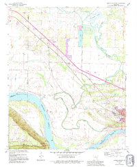
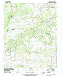
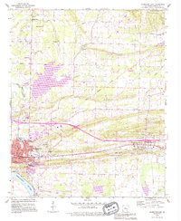 1990 Morrilton East1995 Print · USGSConway County communities come into focus in the 1990s as the suburbs of Morrilton expand toward the banks of the Arkansas River. Researchers can locate family burial plots and historic congregations at Sacred Heart Cem, Lewisburg Cem, and Shady Grove Ch.
 - 1991 Map of Bee Branch, 1995 Print
 1991 Bee Branch1995 Print · USGSBee Branch and the Southside community are documented during the early nineties as they expanded along the ridges of Van Buren County. Researchers can pinpoint historic rural landmarks like Soldier Memorial Cem, Southside Schools, and Pleasant Valley Ch.
 - 1991 Map of Hattieville, 1995 Print
 1991 Hattieville1995 Print · USGSNear the intersection of the foothills and the river bottoms in the early nineties, these Arkansas communities maintained a quiet rural character. Genealogists can locate several family cemeteries and country churches, including Dunham Cem, Beeson Cem, and the Zion Hill Ch.
 - 1991 Map of Formosa, 1995 Print
 1991 Formosa1995 Print · USGSThe hills of Van Buren and Conway counties come alive in the early 1990s as this map traces the family-named settlements of the Arkansas highlands. Researchers can locate remote burial sites and rural steeples like Woolverton Mountain Cem, Halbrooks Cem, and Union Hill Ch.
 - 1991 Map of Morrilton West, 1995 Print
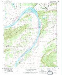
 1991 Morrilton West1995 Print · USGSMorrilton and the Conway County riverfront are shown in the early nineties as the community expanded north of the river's bend. Family historians can trace local roots at Happy Bend Cem, Hill Cem, and the historic Petit Jean State Park grounds.
 - 1991 Map of Gleason, 1995 Print
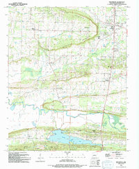
 1991 Gleason1995 Print · USGSThe Arkansas River corridor near the Perry and Faulkner county lines comes into focus in the early 1990s. Genealogists and local historians can locate rural landmarks like Stony Point Cem, Pleasant Hill Ch, and the distinctive Toad Suck Ferry Lock & Dam.
 - 1991 Map of Menifee, 1995 Print
 1991 Menifee1995 Print · USGSConway and Faulkner counties meet along the winding Cadron Creek during the early nineties, showing a landscape of small communities and rural industry. Researchers can find deep-rooted local history at the County Training Sch, Mount Olive, and the Old Indian Reservation Boundary.
 - 1992 Map of Russellville, 1993 Print
 1992 Russellville1993 Print · USGSCentral Arkansas in the early nineties shows a landscape defined by the Arkansas River valley and the surrounding national forests. Trace the development of river towns like Russellville and Dardanelle alongside landmarks such as Lake Dardanelle and Magazine Mtn.
 - 1994 Map of Greenbrier
 1994 Greenbrier1994 Print · USGSGreenbrier and its surrounding ridges come into focus in the early 1990s as the community expanded north of the new reservoir. Genealogists and local historians can locate several rural landmarks including Bethlehem Ch, Estep Cem, and the neighborhoods of Treasure Hills and Wooster.
 - 1994 Map of Damascus
 1994 Damascus1994 Print · USGSThe hill country of Faulkner and Van Buren counties comes to life in the mid-1990s as a landscape of small settlements and creek-bottom farms. Researchers can trace family history through several burial sites like Spires Cem or locate the Old Indian Reservation Boundary.
End of results
Showing maps 1-15 of 15
Top cities of Conway County
Frequently asked questions
- What are the different types of historical maps available for Conway County?
- What is the oldest map of Conway County?
- Where can I purchase historical maps of Conway County for my home or office?
- Where can I download high-res historical maps of Conway County?
- Are there historical topographic maps available for Conway County?
- Is there historical aerial imagery available for Conway County?
- Where are historical maps of Conway County sourced from?