1960s Maps of Crittenden County, Arkansas
Explore 15 historic maps of Crittenden County from the 1960s. These maps offer a rare glimpse into what life looked like during the 1960s — showing old roads, neighborhoods, homes, and landmarks that have changed or disappeared over time.
Whether you're researching your family's past, planning a metal detecting trip, or studying how Crittenden County's landscape evolved across the 1960s, these high-resolution maps are a powerful tool for exploring the history of this region.
- Focus on a specific era: All maps on this page are from the 1960s, giving you a focused view of this time period.
- See what’s changed: Compare century-old streets, trails, and buildings to today's modern landscape using overlays and satellite layers.
- Research with precision: Use these maps for genealogy, historical research, land use analysis, or educational projects.
- View, download, or print: Maps are fully viewable online in high resolution, and can be downloaded or printed for your own records.
Start exploring Crittenden County's history through authentic maps from the 1960s. This is your window into the past.
Crittenden County, AR maps
(15)- 1960 Map of Helena
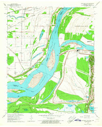
 1960 Helena1960 Print · USGSThe Arkansas and Mississippi Delta regions meet along the great river bends during a period of significant agricultural and rail expansion. Genealogists and historians can trace the paths of the Missouri Pacific railroad through Clarendon or locate landings along the Mississippi River and White River.
 - 1960 Map of Memphis, 1963 Print
 1960 Memphis1963 Print · USGSGreater Memphis and its Arkansas neighbors are shown at a peak of industrial and suburban growth. Trace family history through old landmarks like Locella Ch, the Marion Flying Service, and established cemeteries such as Forest Hill Cem.2 unique versions available
 - 1960 Map of Horseshoe Lake, 1963 Print
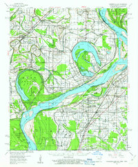 1960 Horseshoe Lake1963 Print · USGSCrittenden and Tunica counties are shown in the early sixties as a patchwork of Delta plantations and river landings. Genealogists can trace family footprints at Joe Beck Plantation, Happy Ch & Cem, and local schoolhouses like Snowden Sch.2 unique versions available
 - 1960 Map of Whitmore, 1966 Print
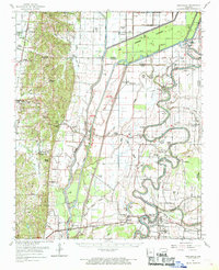
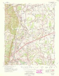
 1960 Whitmore1966 Print · USGSIn the Arkansas delta during the early sixties, the river loops and rail lines shaped every community. Genealogists can trace family landmarks like Wittsburg Cem, Newcastle, and rural schools such as Campbell Sch near the Missouri Pacific RR.
 - 1961 Map of Jericho, 1963 Print
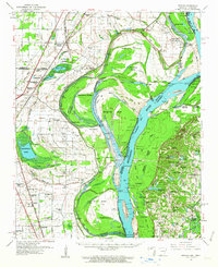 1961 Jericho1963 Print · USGSThe Mississippi River delta at the start of the 1960s reveals a world of island farming and rail-side settlements along the Arkansas-Tennessee border. Genealogists can trace family roots through numerous local landmarks, including Jericho, Clarkedale, and the St Paul School and Church.
 - 1961 Map of Horn Lake, 1978 Print
 1961 Horn Lake1978 Print · USGSDeSoto County and the Mississippi River bottoms are captured here in the early sixties as rural life centered on the river and rail lines. Genealogists can locate family landmarks like Howard Plantation, Lakeside Cem, and numerous country churches like New Hope Ch.
 - 1962 Map of Jericho
 1962 Jericho1962 Print · USGSThe riverfront border of Arkansas and Tennessee is captured here in the early sixties, showing a landscape shaped by the Mississippi River. Genealogists and local historians can trace family roots through sites like Jericho, James Mill, and Lambethville, or locate rural landmarks such as Pecan Point Cem and the Shawnee Sch.
 - 1962 Map of Princedale, 1968 Print
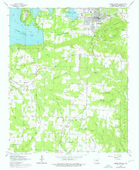
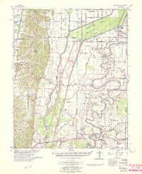
 1962 Princedale1968 Print · USGSEastern Arkansas in the early sixties reveals a landscape shaped by Poinsett Ridge and the winding St. Francis River. Genealogists and local historians can trace family locations like Yarbo Place, rural landmarks such as McDonald Ch, and the stop at Cherry Valley Halt.
 - 1963 Map of Heafer, 1976 Print
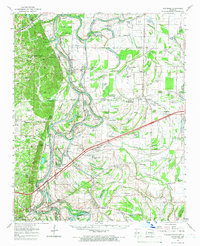
 1963 Heafer1976 Print · USGSHeber Springs and the surrounding Cleburne County hills are shown during a period of growth as the Greers Ferry Lake shoreline stabilized. Researchers can locate rural landmarks like Mt Devonshire Ch, Palestine Cem, and the Old Railroad Grade.
 - 1965 Map of Whitmore
 1965 Whitmore1965 Print · USGSEastern Arkansas at the mid-century reveals a landscape shaped by the St Francis River and the high ground of Crowley s Ridge. Researchers can trace the heritage of rural communities through dozens of landmarks like Wittsburg Cemetery, Harris Chapel, and Campbell Sch.
 - 1965 Map of Southwest Memphis, 1967 Print
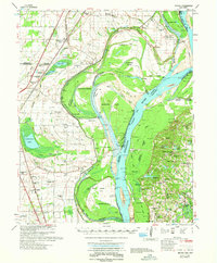
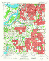 1965 Southwest Memphis1967 Print · USGSMid-century South Memphis and Whitehaven are shown here during a period of significant urban growth and industrial activity. Researchers can trace the footprints of Defense Depot Memphis, the historic grounds of Elmwood Cemetery, and local landmarks like LeMoyne College.5 unique versions available
 - 1965 Map of Northwest Memphis, 1967 Print
 1965 Northwest Memphis1967 Print · USGSThe riverfront and industrial core of Memphis are documented here in the mid-sixties as urban neighborhoods and rail yards met the river. Genealogists and historians can trace local landmarks like Frayser, St Peters Orphanage, and Bridge Junction.3 unique versions available
 - 1966 Map of Princedale
 1966 Princedale1966 Print · USGSEastern Arkansas river life in the mid-sixties centered on the complex drainage of the St Francis River. Genealogists can trace family landmarks like Burr Place and Harefarm Cem or rural centers like Wildwood Ch & Sch.
 - 1966 Map of West Memphis, 1967 Print
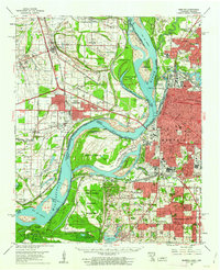
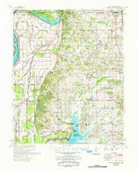
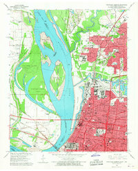
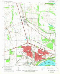 1966 West Memphis1967 Print · USGSMid-century West Memphis and the neighboring seat of Marion are shown during a period of rapid expansion near the Mississippi. Researchers can trace the mid-century rail networks and find local landmarks like the Southland Park Racetrack, Mound City, and the West Memphis Airport.3 unique versions available
 - 1966 Map of Fletcher Lake, 1967 Print
 1966 Fletcher Lake1967 Print · USGSThe riverfront south of Memphis in the mid-sixties reveals a landscape of industrial power and rural resilience. Genealogists and historians can trace the early footprints of Waverly, Riceville, and Millers alongside the Chucalissa Archaeological Park.4 unique versions available
End of results
Showing maps 1-15 of 15
Top cities of Crittenden County
- West Memphis historical maps
- Marion historical maps
- Earle historical maps
- Turrell historical maps
- Crawfordsville historical maps
- Clarkedale historical maps
See more
Frequently asked questions
- What are the different types of historical maps available for Crittenden County?
- What is the oldest map of Crittenden County?
- Where can I purchase historical maps of Crittenden County for my home or office?
- Where can I download high-res historical maps of Crittenden County?
- Are there historical topographic maps available for Crittenden County?
- Is there historical aerial imagery available for Crittenden County?
- Where are historical maps of Crittenden County sourced from?