1970s Maps of Eagletie, Arkansas
Explore 2 historic maps of Eagletie from the 1970s. These maps offer a rare glimpse into what life looked like during the 1970s — showing old roads, neighborhoods, homes, and landmarks that have changed or disappeared over time.
Whether you're researching your family's past, planning a metal detecting trip, or studying how Eagletie's landscape evolved across the 1970s, these high-resolution maps are a powerful tool for exploring the history of this region.
- Focus on a specific era: All maps on this page are from the 1970s, giving you a focused view of this time period.
- See what’s changed: Compare century-old streets, trails, and buildings to today's modern landscape using overlays and satellite layers.
- Research with precision: Use these maps for genealogy, historical research, land use analysis, or educational projects.
- View, download, or print: Maps are fully viewable online in high resolution, and can be downloaded or printed for your own records.
Start exploring Eagletie's history through authentic maps from the 1970s. This is your window into the past.
Eagletie, AR maps
(2)- 1973 Map of Princeton East, 1975 Print
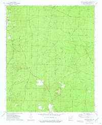 1973 Princeton East1975 Print · USGSDallas County was a landscape of timber and rural community in the 1970s, as seen through this detailed survey. Researchers can trace family sites at Princeton Cem and Liberty Cem, or follow old paths like Eagle Tram Road and Billy Jones Road.2 unique versions available
 - 1978 Map of Princeton
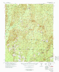 1978 Princeton1978 Print · USGSSouth Arkansas rural life is captured here in the late 1970s as timber and rail lines defined the local economy. Researchers can trace family roots at Princeton Cem and Macedonia Ch or locate industrial sites like the Fish Hatchery and numerous Gravel Pits.
End of results
Showing maps 1-2 of 2
Top cities near Eagletie
Frequently asked questions
- What are the different types of historical maps available for Eagletie?
- What is the oldest map of Eagletie?
- Where can I purchase historical maps of Eagletie for my home or office?
- Where can I download high-res historical maps of Eagletie?
- Are there historical topographic maps available for Eagletie?
- Is there historical aerial imagery available for Eagletie?
- Where are historical maps of Eagletie sourced from?