1950s Maps of Desha County, Arkansas
Explore 8 historic maps of Desha County from the 1950s. These maps offer a rare glimpse into what life looked like during the 1950s — showing old roads, neighborhoods, homes, and landmarks that have changed or disappeared over time.
Whether you're researching your family's past, planning a metal detecting trip, or studying how Desha County's landscape evolved across the 1950s, these high-resolution maps are a powerful tool for exploring the history of this region.
- Focus on a specific era: All maps on this page are from the 1950s, giving you a focused view of this time period.
- See what’s changed: Compare century-old streets, trails, and buildings to today's modern landscape using overlays and satellite layers.
- Research with precision: Use these maps for genealogy, historical research, land use analysis, or educational projects.
- View, download, or print: Maps are fully viewable online in high resolution, and can be downloaded or printed for your own records.
Start exploring Desha County's history through authentic maps from the 1950s. This is your window into the past.
Desha County, AR maps
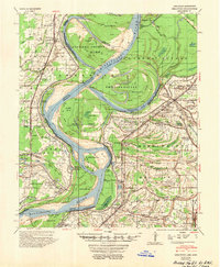
(8)- 1950 Map of Helena
 1950 Helena1950 Print · USGSMid-century Phillips County and the surrounding Delta region are shown at a peak of rail and river commerce. Genealogists and historians can trace family locations through numerous rural communities like Old Austin, Cotton Plant, and West Helena, or follow the routes of the Missouri Pacific RR across Grand Prairie.2 unique versions available
 - 1953 Map of Greenwood, 1966 Print
 1953 Greenwood1966 Print · USGSThe Mississippi Delta in the mid-fifties is captured here as a thriving network of river towns, railroads, and oxbow lakes. Researchers can trace the legacy of the Illinois Central Railroad and locate landmarks like the State Penal Farm and Greenville Air Force Base.5 unique versions available
 - 1954 Map of Mellwood
 1954 Mellwood1954 Print · USGSThe Arkansas and Mississippi borderlands are captured here in the mid-1950s as the Delta landscape adapted to massive flood control projects. Genealogists can trace family names at White Parker Cem and old settlements like Mellwood or Rena Lara.
 - 1954 Map of Henrico
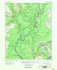 1954 Henrico1954 Print · USGSThe White River bottoms and the Laconia Circle in the mid-1950s reveal a landscape shaped by shifting river channels and timber transport. Genealogists can trace family names and local landmarks like Henrico, Malcolm Chapel & Cem, and the Stimson Co Tram.
 - 1955 Map of McGehee
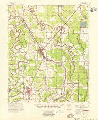 1955 McGehee1955 Print · USGSSoutheast Arkansas in the mid-fifties shows a landscape defined by the Missouri Pacific rail line and a massive network of irrigation canals. Genealogists can trace family footprints at Loggy Bayou Sch Ch & Cem, Masonville, and the Wolff Project Sch.
 - 1955 Map of Helena, 1967 Print
 1955 Helena1967 Print · USGSThe Arkansas Delta and Mississippi floodplains are captured here in the mid-fifties, during a period of expanding flood control and rail commerce. Researchers can trace the extensive Chicago Rock Island and Pacific RR lines and locate sites like the Arkansas State College Experimental Rice Farm or Friars Point.2 unique versions available
 - 1956 Map of Greenwood
 1956 Greenwood1956 Print · USGSThe Mississippi Delta in the mid-fifties is captured here during a period of significant military and agricultural activity. Researchers can trace the rail lines of the Illinois Central RR, find the Greenville Air Force Base, or locate the State Penal Farm.
 - 1959 Map of Helena
 1959 Helena1959 Print · USGSThe Arkansas and Mississippi Delta regions are captured here in the late fifties, showing a landscape defined by the Mississippi River and the Grand Prairie. Genealogists and researchers can trace the rail networks of the Illinois Central RR and locate community landmarks like Helena and the White River National Wildlife Refuge.
End of results
Showing maps 1-8 of 8
Top cities of Desha County
- McGehee historical maps
- Dumas historical maps
- Arkansas City historical maps
- Mitchellville historical maps
- Watson historical maps
- Reed historical maps
Frequently asked questions
- What are the different types of historical maps available for Desha County?
- What is the oldest map of Desha County?
- Where can I purchase historical maps of Desha County for my home or office?
- Where can I download high-res historical maps of Desha County?
- Are there historical topographic maps available for Desha County?
- Is there historical aerial imagery available for Desha County?
- Where are historical maps of Desha County sourced from?