Old Maps of Desha County, Arkansas for Academic Research
Study the evolution of Desha County with 194 high-resolution historic maps. Whether you're teaching, researching, or modeling changes in land use, these maps provide essential visual documentation of urban, environmental, and geographic change.
- Analyze long-term change: Track patterns in development, transportation, and natural features.
- Ideal for environmental or urban studies: Support academic projects with primary historical map data.
- Use in the classroom or lab: Educators and researchers rely on these maps to bring historical context to life.
These maps are a powerful tool for teaching, research, and visualizing how Desha County has changed over the decades.
Desha County, AR maps
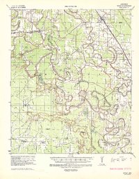
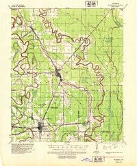
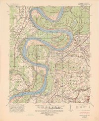
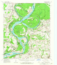
(194)- 1930 Map of Mellwood
 1930 Mellwood1930 Print · USGSThe Mississippi Delta's shifting banks and rail-tied settlements are frozen in time just before the great mid-century levee expansions. Trace the history of the 1910s floods via the Ferguson Crevasse and locate river-dependent towns like Mellwood and Deeson.
 - 1933 Map of Lamont
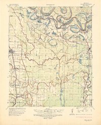
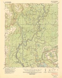
 1933 Lamont1933 Print · USGSThe Mississippi River delta in the early 1930s is captured here just after the historic floods of the previous decade. Genealogists and historians can trace the foundations of Arkansas City, locate rural sites like Eutaw Store, and follow the tracks of the Mo Pac RR.
 - 1935 Map of Rotan, 1942 Print
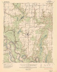
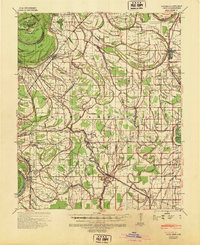
 1935 Rotan1942 Print · USGSThe Arkansas delta comes to life in the mid-1930s as a complex network of timber camps, bayous, and rail towns. Genealogists can trace the rural communities of Rotan and Gould, or locate family sites at Thomas Cem and New Bethel Ch.2 unique versions available
 - 1935 Map of Red Fork, 1943 Print
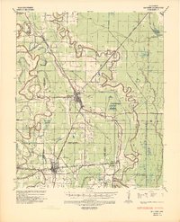
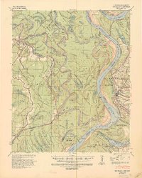
 1935 Red Fork1943 Print · USGSDesha County's riverfront and rail lines are captured here in the mid-1930s, showing a landscape shaped by the Arkansas River. Researchers can trace the Missouri Pacific corridor through Dumas or locate the Indian Mound near Red Fork.3 unique versions available
 - 1935 Map of Gillett, 1945 Print
 1935 Gillett1945 Print · USGSThe river plains around Gillett were defined by the shifting Arkansas River and the arrival of the railroad in the 1930s. Genealogists can locate family landmarks like Luther Cem, Hostetter Sch, and the remote One Horse Store.2 unique versions available
 - 1936 Map of McGehee, 1937 Print
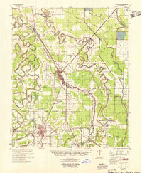
 1936 McGehee1937 Print · USGSThe Arkansas Delta during the mid-thirties comes into focus through its dense network of bayous, rail junctions, and river towns. Genealogists and historians can trace the foundations of Mcgehee and Dermott, while locating rural landmarks like Loggy Bayou Church and the ancient INDIAN MOUNDS.
 - 1937 Map of McGehee, 1952 Print
 1937 McGehee1952 Print · USGSThe Arkansas Delta comes alive in the late 1930s as a complex network of bayous and rail lines. Genealogists and historians can trace the foundations of McGehee and Dermott, or locate rural landmarks like Providence Church and the Indian Mounds.
 - 1939 Map of Henrico, 1941 Print
 1939 Henrico1941 Print · USGSThe river bottomlands of the Arkansas delta are mapped here in the late 1930s as flood control efforts reshaped the basin. Genealogists can trace early landmarks like Fairview Ch & Sch, Henrico Cem, and the small settlement at Lagrue Springs.2 unique versions available
 - 1939 Map of Pace, 1942 Print
 1939 Pace1942 Print · USGSBolivar County in the late 1930s is a landscape of thriving Delta towns and extensive plantation land. Genealogists can locate family landmarks like Kirks Plantation, the Beulah Cem, and rural churches such as Pitts Chapel and Macedonia Ch.2 unique versions available
 - 1939 Map of Big Island, 1945 Print
 1939 Big Island1945 Print · USGSThe confluence of the White, Arkansas, and Mississippi Rivers is captured here in the late 1930s, showing a land defined by shifting channels and strategic landings. Researchers can trace the river economy through Campbell Ferry and Pleasant Green Ch & Cem near Rosedale.3 unique versions available
 - 1939 Map of Mellwood, 1946 Print
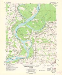
 1939 Mellwood1946 Print · USGSThe Mississippi River Delta of the late thirties reveals a landscape of massive levee projects and rail-dependent river towns. Genealogists can trace family roots through numerous rural church sites and burial grounds like Jerusalem Ch & Cem, St Joseph Ch & Cem, and the unique Laconia Circle.2 unique versions available
 - 1939 Map of Lamont, 1961 Print
 1939 Lamont1961 Print · USGSThe Mississippi Delta in the late thirties reveals a landscape in transition as engineering cut-offs reshaped the river's path. Researchers can locate vanished landings like Monterey Ldg, trace the Yazoo and Mississippi Valley rail line, and find rural centers like Morning Star Ch & Sch.3 unique versions available
 - 1948 Map of Helena
 1948 Helena1948 Print · USGSEastern Arkansas and the Mississippi Delta are captured here just after the war, showing a landscape defined by its great rivers and rail lines. Genealogists can trace family locations near Bemis Plantation, Helena, and smaller rail stops like Wheatley and Moro.
 - 1950 Map of Helena
 1950 Helena1950 Print · USGSMid-century Phillips County and the surrounding Delta region are shown at a peak of rail and river commerce. Genealogists and historians can trace family locations through numerous rural communities like Old Austin, Cotton Plant, and West Helena, or follow the routes of the Missouri Pacific RR across Grand Prairie.2 unique versions available
 - 1953 Map of Greenwood, 1966 Print
 1953 Greenwood1966 Print · USGSThe Mississippi Delta in the mid-fifties is captured here as a thriving network of river towns, railroads, and oxbow lakes. Researchers can trace the legacy of the Illinois Central Railroad and locate landmarks like the State Penal Farm and Greenville Air Force Base.5 unique versions available
 - 1954 Map of Mellwood
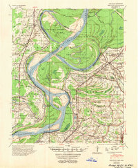 1954 Mellwood1954 Print · USGSThe Arkansas and Mississippi borderlands are captured here in the mid-1950s as the Delta landscape adapted to massive flood control projects. Genealogists can trace family names at White Parker Cem and old settlements like Mellwood or Rena Lara.
 - 1954 Map of Henrico
 1954 Henrico1954 Print · USGSThe White River bottoms and the Laconia Circle in the mid-1950s reveal a landscape shaped by shifting river channels and timber transport. Genealogists can trace family names and local landmarks like Henrico, Malcolm Chapel & Cem, and the Stimson Co Tram.
 - 1955 Map of McGehee
 1955 McGehee1955 Print · USGSSoutheast Arkansas in the mid-fifties shows a landscape defined by the Missouri Pacific rail line and a massive network of irrigation canals. Genealogists can trace family footprints at Loggy Bayou Sch Ch & Cem, Masonville, and the Wolff Project Sch.
 - 1955 Map of Helena, 1967 Print
 1955 Helena1967 Print · USGSThe Arkansas Delta and Mississippi floodplains are captured here in the mid-fifties, during a period of expanding flood control and rail commerce. Researchers can trace the extensive Chicago Rock Island and Pacific RR lines and locate sites like the Arkansas State College Experimental Rice Farm or Friars Point.2 unique versions available
 - 1956 Map of Greenwood
 1956 Greenwood1956 Print · USGSThe Mississippi Delta in the mid-fifties is captured here during a period of significant military and agricultural activity. Researchers can trace the rail lines of the Illinois Central RR, find the Greenville Air Force Base, or locate the State Penal Farm.
 - 1959 Map of Helena
 1959 Helena1959 Print · USGSThe Arkansas and Mississippi Delta regions are captured here in the late fifties, showing a landscape defined by the Mississippi River and the Grand Prairie. Genealogists and researchers can trace the rail networks of the Illinois Central RR and locate community landmarks like Helena and the White River National Wildlife Refuge.
 - 1960 Map of Helena
 1960 Helena1960 Print · USGSThe Arkansas and Mississippi Delta regions meet along the great river bends during a period of significant agricultural and rail expansion. Genealogists and historians can trace the paths of the Missouri Pacific railroad through Clarendon or locate landings along the Mississippi River and White River.
 - 1961 Map of Mellwood, 1965 Print
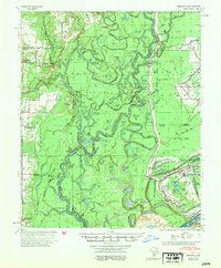
 1961 Mellwood1965 Print · USGSThe Mississippi River delta in the early sixties was a landscape shaped by recent engineering and historic floods. Researchers can trace the results of the Knowlton Crevasse (1912) and locate vanished landmarks like Zion Traveler Ch or Laconia Circle.
 - 1962 Map of Mellwood
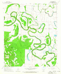
 1962 Mellwood1962 Print · USGSThe Mississippi Delta's shifting riverbanks and floodplain communities are captured here in the early sixties. Genealogists and historians can trace family landmarks like the Zion Traveler Cem, the Laconia Crevasse (1913), and the settlement of Mellwood.
 - 1964 Map of Gourd, 1965 Print
 1964 Gourd1965 Print · USGSSoutheast Arkansas in the mid-1960s is defined by the winding course of Bayou Bartholomew and its sprawling backwater brakes. Researchers can trace rural life through landmarks like Valley Farm, Orange Chapel, and ancient Indian Mounds.2 unique versions available
Showing maps 1-25 of 194
Top cities of Desha County
- McGehee historical maps
- Dumas historical maps
- Arkansas City historical maps
- Mitchellville historical maps
- Watson historical maps
- Reed historical maps
Frequently asked questions
- What are the different types of historical maps available for Desha County?
- What is the oldest map of Desha County?
- Where can I purchase historical maps of Desha County for my home or office?
- Where can I download high-res historical maps of Desha County?
- Are there historical topographic maps available for Desha County?
- Is there historical aerial imagery available for Desha County?
- Where are historical maps of Desha County sourced from?