1980s Maps of Desha County, Arkansas
Explore 10 historic maps of Desha County from the 1980s. These maps offer a rare glimpse into what life looked like during the 1980s — showing old roads, neighborhoods, homes, and landmarks that have changed or disappeared over time.
Whether you're researching your family's past, planning a metal detecting trip, or studying how Desha County's landscape evolved across the 1980s, these high-resolution maps are a powerful tool for exploring the history of this region.
- Focus on a specific era: All maps on this page are from the 1980s, giving you a focused view of this time period.
- See what’s changed: Compare century-old streets, trails, and buildings to today's modern landscape using overlays and satellite layers.
- Research with precision: Use these maps for genealogy, historical research, land use analysis, or educational projects.
- View, download, or print: Maps are fully viewable online in high resolution, and can be downloaded or printed for your own records.
Start exploring Desha County's history through authentic maps from the 1980s. This is your window into the past.
Desha County, AR maps
(10)- 1981 Map of Mc Arthur, 1982 Print
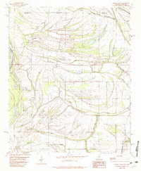
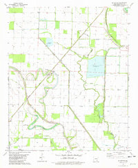 1981 Mc Arthur1982 Print · USGSDesha County, Arkansas, appears in the early eighties as a landscape defined by the winding Bayou Macon and a network of Delta drainage sloughs. Genealogists and local historians can trace small rural communities through landmarks like Warrington Cemetery, Sims Chapel, and McArthur.
 - 1981 Map of Halley, 1982 Print
 1981 Halley1982 Print · USGSSoutheast Arkansas in the early eighties was defined by the intersection of the Missouri Pacific railroad and the winding Bayou Macon. Researchers can trace the layout of small communities like Halley and Bellaire or find local burial sites including Holly Grove Cem and Anderson Cem.
 - 1981 Map of Mc Gehee North, 1982 Print
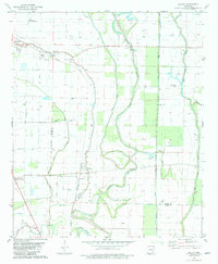
 1981 Mc Gehee North1982 Print · USGSDesha and Drew counties are captured here in the early 1980s as agricultural and rail networks shaped life in the Arkansas Delta. Genealogists can locate several family and community landmarks, including Seven Star Cem, Loggy Bayou Ch, and the streets of McGehee.
 - 1981 Map of Mc Gehee South, 1982 Print
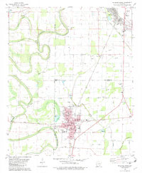 1981 Mc Gehee South1982 Print · USGSSoutheast Arkansas in the early eighties shows a landscape of river-bend farms and rail-line towns along the MISSOURI PACIFIC. Genealogists can trace family names at Duncan Cem, Youngs Cem, and the historic Morris-Booker Memorial College in Dermott.
 - 1982 Map of Laconia
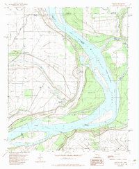 1982 Laconia1982 Print · USGSThe Arkansas-Mississippi borderlands along the great river are captured here in the early eighties. Researchers can trace family sites at Mt Pleasant Ch and Luke Cem, or locate riverside landmarks like Cessions Landing and Island No 69.
 - 1982 Map of Round Lake
 1982 Round Lake1982 Print · USGSThe Bolivar County delta in the early eighties is a landscape of slow bayous and rail-side settlements along the Illinois Central Gulf tracks. Genealogists can trace family roots at Round Lake Cem, Hooper Chapel, or the vanished corners of Rochdale and Deeson.
 - 1983 Map of Greenwood
 1983 Greenwood1983 Print · USGSThe Mississippi Delta in the early eighties shows a landscape of rail-connected towns and vast river systems. Genealogists and historians can trace family roots in towns like Mound Bayou, Ruleville, and the grounds of Mississippi Valley State University.
 - 1984 Map of Clarksdale, 1985 Print
 1984 Clarksdale1985 Print · USGSThe Mississippi Delta in the 1980s shows a landscape defined by its great river meanders and a dense network of bayous and rail lines. Researchers can trace the path of the Illinois Central Gulf through Clarksdale or locate river landmarks like Moon Lake and Friars Point.
 - 1986 Map of De Witt
 1986 De Witt1986 Print · USGSThe Arkansas Delta in the mid-1980s was a landscape defined by massive river locks, state prison farms, and the rail-side grain towns of Arkansas County. Researchers can trace the path of the St Louis Southwestern Railway through settlements like De Witt, Altheimer, and Humphrey.2 unique versions available
 - 1986 Map of Dumas
 1986 Dumas1986 Print · USGSSoutheast Arkansas in the mid-eighties shows a landscape defined by the winding Mississippi River and the Missouri Pacific Railroad corridor. Genealogists can trace family roots through river towns like Arkansas City and the rail-junction history of McGehee.2 unique versions available
End of results
Showing maps 1-10 of 10
Top cities of Desha County
- McGehee historical maps
- Dumas historical maps
- Arkansas City historical maps
- Mitchellville historical maps
- Watson historical maps
- Reed historical maps
Frequently asked questions
- What are the different types of historical maps available for Desha County?
- What is the oldest map of Desha County?
- Where can I purchase historical maps of Desha County for my home or office?
- Where can I download high-res historical maps of Desha County?
- Are there historical topographic maps available for Desha County?
- Is there historical aerial imagery available for Desha County?
- Where are historical maps of Desha County sourced from?