1970s Maps of McGehee, Arkansas
Explore 4 historic maps of McGehee from the 1970s. These maps offer a rare glimpse into what life looked like during the 1970s — showing old roads, neighborhoods, homes, and landmarks that have changed or disappeared over time.
Whether you're researching your family's past, planning a metal detecting trip, or studying how McGehee's landscape evolved across the 1970s, these high-resolution maps are a powerful tool for exploring the history of this region.
- Focus on a specific era: All maps on this page are from the 1970s, giving you a focused view of this time period.
- See what’s changed: Compare century-old streets, trails, and buildings to today's modern landscape using overlays and satellite layers.
- Research with precision: Use these maps for genealogy, historical research, land use analysis, or educational projects.
- View, download, or print: Maps are fully viewable online in high resolution, and can be downloaded or printed for your own records.
Start exploring McGehee's history through authentic maps from the 1970s. This is your window into the past.
McGehee, AR maps
(4)- 1975 Map of Mc Gehee SW, 1976 Print
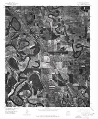
 1975 Mc Gehee SW1976 Print · USGSSoutheast Arkansas farmland and the winding river bends near Dermott are captured in this mid-seventies aerial survey. Genealogists and local historians can trace the street layouts of Mc Gehee and find the rural locations of Masonville and Baxter.
 - 1975 Map of Mc Gehee NW, 1976 Print
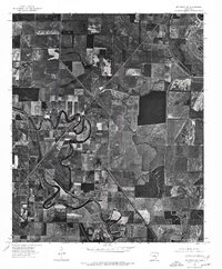
 1975 Mc Gehee NW1976 Print · USGSDesha County agriculture and river dynamics are captured here in the mid-seventies, showing the intersection of rural life and the Delta landscape. Genealogists and historians can trace the early layouts of Tillar and Mc Gehee along the winding Bayou Bartholomew.
 - 1975 Map of Mc Gehee NE, 1976 Print
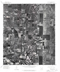
 1975 Mc Gehee NE1976 Print · USGSDesha County farmland is captured in sharp detail in the mid-seventies, showing the intersection of agriculture and the Mississippi Delta's natural drainage. Genealogists and researchers can trace the vicinity of Mc Arthur and the oxbows of Bayou Macon.
 - 1975 Map of Mc Gehee SE, 1976 Print
 1975 Mc Gehee SE1976 Print · USGSSoutheast Desha County is shown in the mid-1970s through this aerial orthophoto, revealing the deep-delta agricultural patterns of the Arkansas landscape. Genealogists and local historians can trace the rural layout around Mc Gehee, Halley, and the junctions of the regional transport network.
End of results
Showing maps 1-4 of 4
Top cities near McGehee
- Dumas historical maps
- Dermott historical maps
- Arkansas City historical maps
- Tillar historical maps
- Winchester historical maps
- Reed historical maps
Frequently asked questions
- What are the different types of historical maps available for McGehee?
- What is the oldest map of McGehee?
- Where can I purchase historical maps of McGehee for my home or office?
- Where can I download high-res historical maps of McGehee?
- Are there historical topographic maps available for McGehee?
- Is there historical aerial imagery available for McGehee?
- Where are historical maps of McGehee sourced from?