1990s Maps of Denning, Arkansas
Explore 3 historic maps of Denning from the 1990s. These maps offer a rare glimpse into what life looked like during the 1990s — showing old roads, neighborhoods, homes, and landmarks that have changed or disappeared over time.
Whether you're researching your family's past, planning a metal detecting trip, or studying how Denning's landscape evolved across the 1990s, these high-resolution maps are a powerful tool for exploring the history of this region.
- Focus on a specific era: All maps on this page are from the 1990s, giving you a focused view of this time period.
- See what’s changed: Compare century-old streets, trails, and buildings to today's modern landscape using overlays and satellite layers.
- Research with precision: Use these maps for genealogy, historical research, land use analysis, or educational projects.
- View, download, or print: Maps are fully viewable online in high resolution, and can be downloaded or printed for your own records.
Start exploring Denning's history through authentic maps from the 1990s. This is your window into the past.
Denning, AR maps
(3)- 1992 Map of Russellville, 1993 Print
 1992 Russellville1993 Print · USGSCentral Arkansas in the early nineties shows a landscape defined by the Arkansas River valley and the surrounding national forests. Trace the development of river towns like Russellville and Dardanelle alongside landmarks such as Lake Dardanelle and Magazine Mtn.
 - 1993 Map of Coal Hill
 1993 Coal Hill1993 Print · USGSCoal Hill and the Arkansas River valley are shown in the early nineties as the region balanced its coal mining heritage with the waters of Lake Dardanelle. Genealogists can locate numerous family burial sites like Huddleston Cem and Burnett Cem near the Strip Mine workings.
 - 1993 Map of Ozark
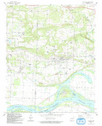
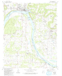 1993 Ozark1993 Print · USGSThe riverfront town of Ozark and the surrounding Arkansas River valley are shown in the early nineties, centered on the engineering of the Ozark-Jeta Taylor Lock and Dam. Researchers can trace rural lineages through sites like Pilot Grove Cem, St Marys Ch, and the town of Denning.
End of results
Showing maps 1-3 of 3
Top cities near Denning
- Clarksville historical maps
- Ozark historical maps
- Paris historical maps
- Coal Hill historical maps
- Altus historical maps
- Hartman historical maps
See more
Frequently asked questions
- What are the different types of historical maps available for Denning?
- What is the oldest map of Denning?
- Where can I purchase historical maps of Denning for my home or office?
- Where can I download high-res historical maps of Denning?
- Are there historical topographic maps available for Denning?
- Is there historical aerial imagery available for Denning?
- Where are historical maps of Denning sourced from?