1940s Maps of Garland County, Arkansas
Explore 2 historic maps of Garland County from the 1940s. These maps offer a rare glimpse into what life looked like during the 1940s — showing old roads, neighborhoods, homes, and landmarks that have changed or disappeared over time.
Whether you're researching your family's past, planning a metal detecting trip, or studying how Garland County's landscape evolved across the 1940s, these high-resolution maps are a powerful tool for exploring the history of this region.
- Focus on a specific era: All maps on this page are from the 1940s, giving you a focused view of this time period.
- See what’s changed: Compare century-old streets, trails, and buildings to today's modern landscape using overlays and satellite layers.
- Research with precision: Use these maps for genealogy, historical research, land use analysis, or educational projects.
- View, download, or print: Maps are fully viewable online in high resolution, and can be downloaded or printed for your own records.
Start exploring Garland County's history through authentic maps from the 1940s. This is your window into the past.
Garland County, AR maps
(2)- 1948 Map of Malvern, 1957 Print
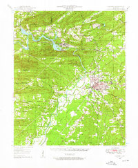 1948 Malvern1957 Print · USGSHot Spring County and the Ouachita River valley are captured here just after the war, showing the industrial growth and rural character of the region. Researchers can trace the development of Malvern and find vanished landmarks like Antioch Sch, Jones Mills, and the Rockport Cem.3 unique versions available
 - 1949 Map of Malvern
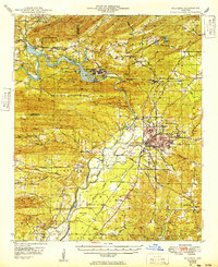 1949 Malvern1949 Print · USGSMalvern and the Ouachita River valley are shown here in the late 1940s, as industrial sites and new reservoirs began to reshape the Hot Spring County landscape. Genealogists and local historians can locate many rural landmarks, including Potash Sulphur Springs, Taylor Chapel, and the Price Cem.
End of results
Showing maps 1-2 of 2
Top cities of Garland County
- Hot Springs historical maps
- Hot Springs Village historical maps
- Mountain Pine historical maps
- Fountain Lake historical maps
- Fountain Lake historical maps
- Lonsdale historical maps
Frequently asked questions
- What are the different types of historical maps available for Garland County?
- What is the oldest map of Garland County?
- Where can I purchase historical maps of Garland County for my home or office?
- Where can I download high-res historical maps of Garland County?
- Are there historical topographic maps available for Garland County?
- Is there historical aerial imagery available for Garland County?
- Where are historical maps of Garland County sourced from?