1970s Maps of Fountain Lake, Arkansas
Explore 2 historic maps of Fountain Lake from the 1970s. These maps offer a rare glimpse into what life looked like during the 1970s — showing old roads, neighborhoods, homes, and landmarks that have changed or disappeared over time.
Whether you're researching your family's past, planning a metal detecting trip, or studying how Fountain Lake's landscape evolved across the 1970s, these high-resolution maps are a powerful tool for exploring the history of this region.
- Focus on a specific era: All maps on this page are from the 1970s, giving you a focused view of this time period.
- See what’s changed: Compare century-old streets, trails, and buildings to today's modern landscape using overlays and satellite layers.
- Research with precision: Use these maps for genealogy, historical research, land use analysis, or educational projects.
- View, download, or print: Maps are fully viewable online in high resolution, and can be downloaded or printed for your own records.
Start exploring Fountain Lake's history through authentic maps from the 1970s. This is your window into the past.
Fountain Lake, AR maps
(2)- 1972 Map of Goosepond Mountain, 1974 Print
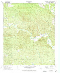 1972 Goosepond Mountain1974 Print · USGSThe borderlands of Saline and Garland Counties are captured in the early 1970s during the early development of Hot Springs Village. Researchers can trace old family sites and local landmarks like Talley Cem, Antioch Ch, and the Lookout Tower on Goosepond Mountain.3 unique versions available
 - 1972 Map of Fountain Lake, 1974 Print
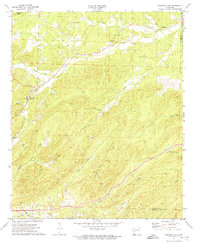 1972 Fountain Lake1974 Print · USGSGarland County and the surrounding hills were witnessing the early growth of Hot Springs Village and Fountain Lake in the early 1970s. Researchers can trace historic cemeteries and churches such as McClendon Cem, Rockdale Ch, and the Missouri Pacific rail line.3 unique versions available
End of results
Showing maps 1-2 of 2
Top cities near Fountain Lake
- Hot Springs historical maps
- Hot Springs Village historical maps
- Malvern historical maps
- Rockport historical maps
- Traskwood historical maps
- Magnet Cove historical maps
See more
Top neighborhoods of Fountain Lake
Frequently asked questions
- What are the different types of historical maps available for Fountain Lake?
- What is the oldest map of Fountain Lake?
- Where can I purchase historical maps of Fountain Lake for my home or office?
- Where can I download high-res historical maps of Fountain Lake?
- Are there historical topographic maps available for Fountain Lake?
- Is there historical aerial imagery available for Fountain Lake?
- Where are historical maps of Fountain Lake sourced from?