1980s Maps of Oak Grove Heights, Arkansas
Explore 5 historic maps of Oak Grove Heights from the 1980s. These maps offer a rare glimpse into what life looked like during the 1980s — showing old roads, neighborhoods, homes, and landmarks that have changed or disappeared over time.
Whether you're researching your family's past, planning a metal detecting trip, or studying how Oak Grove Heights's landscape evolved across the 1980s, these high-resolution maps are a powerful tool for exploring the history of this region.
- Focus on a specific era: All maps on this page are from the 1980s, giving you a focused view of this time period.
- See what’s changed: Compare century-old streets, trails, and buildings to today's modern landscape using overlays and satellite layers.
- Research with precision: Use these maps for genealogy, historical research, land use analysis, or educational projects.
- View, download, or print: Maps are fully viewable online in high resolution, and can be downloaded or printed for your own records.
Start exploring Oak Grove Heights's history through authentic maps from the 1980s. This is your window into the past.
Oak Grove Heights, AR maps
(5)- 1983 Map of Paragould East, 1984 Print
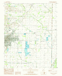 1983 Paragould East1984 Print · USGSGreene County agriculture and the eastward expansion of Paragould are on full display in the early eighties. Genealogists and researchers can trace local landmarks like Morning Star, Cotton Belt, and the intricate fish ponds near Lake Side.2 unique versions available
 - 1984 Map of Marmaduke
 1984 Marmaduke1984 Print · USGSGreene County in the mid-eighties shows a landscape divided by the prominent Crowleys Ridge and the developing town of Marmaduke. Genealogists and local historians can trace family properties near Henderson or along the banks of Hurricane Creek and Pigeon Roost Creek.2 unique versions available
 - 1984 Map of Paragould West
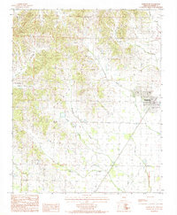
 1984 Paragould West1984 Print · USGSGreene County in the early eighties shows a community in transition as the city of Paragould expands toward the western hills. Researchers can trace family roots through the Greene High area or locate specific landmarks like the Drive-In Theater and the St Louis rail corridor.3 unique versions available
 - 1984 Map of Paragould
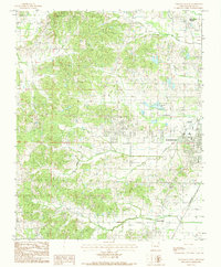
 1984 Paragould1984 Print · USGSNortheast Arkansas and the Missouri Bootheel appear here in the mid-1980s as a landscape of ridge-top towns and engineered delta drainage. Genealogists and historians can locate rural landmarks like Oak Grove Church, trace the St Louis San Francisco RR, or explore the limits of Crowleys Ridge State Park.2 unique versions available
 - 1984 Map of Lafe
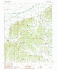 1984 Lafe1984 Print · USGSGreene County in the mid-eighties shows a landscape defined by the rise of Crowleys Ridge between the Cache River and the local rail line. Genealogists can trace family footprints in Beech Grove, Hooker, and Gainesville during this era.2 unique versions available
End of results
Showing maps 1-5 of 5
Top cities near Oak Grove Heights
- Paragould historical maps
- Leachville historical maps
- Rector historical maps
- Brookland historical maps
- Monette historical maps
- Marmaduke historical maps
See more
Frequently asked questions
- What are the different types of historical maps available for Oak Grove Heights?
- What is the oldest map of Oak Grove Heights?
- Where can I purchase historical maps of Oak Grove Heights for my home or office?
- Where can I download high-res historical maps of Oak Grove Heights?
- Are there historical topographic maps available for Oak Grove Heights?
- Is there historical aerial imagery available for Oak Grove Heights?
- Where are historical maps of Oak Grove Heights sourced from?