1900s (20th Century) Maps of Izard County, Arkansas
Explore 52 historic maps of Izard County from the 1900s (20th Century). These maps offer a rare glimpse into what life looked like during the 1900s — showing old roads, neighborhoods, homes, and landmarks that have changed or disappeared over time.
Whether you're researching your family's past, planning a metal detecting trip, or studying how Izard County's landscape evolved across the 1900s, these high-resolution maps are a powerful tool for exploring the history of this region.
- Focus on a specific era: All maps on this page are from the 1900s, giving you a focused view of this time period.
- See what’s changed: Compare century-old streets, trails, and buildings to today's modern landscape using overlays and satellite layers.
- Research with precision: Use these maps for genealogy, historical research, land use analysis, or educational projects.
- View, download, or print: Maps are fully viewable online in high resolution, and can be downloaded or printed for your own records.
Start exploring Izard County's history through authentic maps from the 1900s. This is your window into the past.
Izard County, AR maps
(52)- 1942 Map of Bethesda
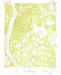 1942 Bethesda1942 Print · USGSIndependence County during the early 1940s reveals a landscape of ridge-top farms and river-bottom commerce. Genealogists can trace family roots through local landmarks like Gill Cem, O'Neal Sch, and the riverside crossing at Walls Ferry.4 unique versions available
 - 1942 Map of Mt Pleasant, 1945 Print
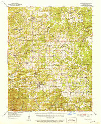
 1942 Mt Pleasant1945 Print · USGSIzard County in the 1940s was a landscape of deep hollows and active mining operations near the Independence County line. Genealogists and historians can trace rural family legacies through local landmarks like Gid Sch, Mt Lebanon Ch, and the Barren Fork Cem.5 unique versions available
 - 1943 Map of Sandtown
 1943 Sandtown1943 Print · USGSThe rural uplands of Independence and Sharp Counties come into focus during the early 1940s, revealing a landscape of remote mines and creek-side settlements. Researchers can trace historic family-named landmarks such as Polk Southard Mines, Martins Store, and Wolf Sch.4 unique versions available
 - 1945 Map of Harrison
 1945 Harrison1945 Print · USGSThe Ozark and Boston Mountains straddle the Missouri-Arkansas border during the mid-forties, showing a landscape of forest ridges and river valleys. Genealogists and historians can trace rail-connected towns like Monett and West Plains or early lake developments at Bull Shoals Res and Norfork Lake.
 - 1949 Map of Harrison
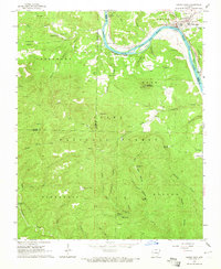
 1949 Harrison1949 Print · USGSThe Ozark highlands of northern Arkansas and southern Missouri are shown just after the war, when the White River still followed its original course. Genealogists and historians can trace rail lines like the Missouri & Arkansas RR and locate rural hubs like Harrison, Eureka Springs, and Mountain Home.
 - 1950 Map of Salem, 1973 Print
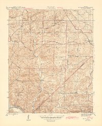
 1950 Salem1973 Print · USGSFulton County and the surrounding Ozark borderlands are captured here in the mid-twentieth century, centered on the community of Salem. Local researchers can locate family homesteads near landmarks like Wesley Chapel, Bexar, and the Liberty Hill Ch.2 unique versions available
 - 1951 Map of Salem
 1951 Salem1951 Print · USGSFulton County settlements and timberlands are mapped here in detail during the early fifties. Genealogists and local historians can trace family roots through numerous sites like Wesley Chapel, Crossroads Sch, and the Hunter Cem.
 - 1951 Map of Melbourne, 1952 Print
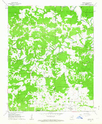
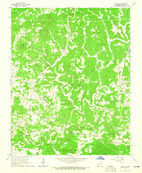
 1951 Melbourne1952 Print · USGSIzard County in the early fifties is captured here as a landscape of interconnected ridge-top farms and creek-bottom hamlets. Researchers can trace ancestral roots at Philadelphia Ch, find the old Oxford Lookout Tower, or locate early settlements like Lunenburg and La Crosse.2 unique versions available
 - 1953 Map of Memphis, 1966 Print
 1953 Memphis1966 Print · USGSEastern Arkansas and the Memphis riverfront are shown here during the mid-century period of regional growth and river management. Local historians can trace the paths of the Chicago Rock Island & Pacific RR through Forrest City or locate river landmarks like President's Island.3 unique versions available
 - 1954 Map of Harrison
 1954 Harrison1954 Print · USGSThe Ozarks and Boston Mountains meet during a period of massive river engineering in the mid-fifties. Researchers can trace the early shorelines of Bull Shoals Lake and Table Rock Reservoir or locate inland towns like Berryville and Harrison.
 - 1956 Map of Memphis
 1956 Memphis1956 Print · USGSThe Mississippi Delta and the bluffs of West Tennessee meet in the mid-fifties, showing a landscape defined by massive river systems and rail hubs. Researchers can trace the path of Crowleys Ridge or locate vanished river landings near Centennial Island and Island No 35.
 - 1956 Map of Russellville
 1956 Russellville1956 Print · USGSThe Arkansas River valley and the surrounding Boston Mountains are captured here in the mid-fifties, showing a landscape of small timber towns and new reservoirs. Genealogists can trace family roots through upland settlements like Pelsor and Witts Springs or locate the campus of Arkansas Polytechnic College.2 unique versions available
 - 1957 Map of Poplar Bluff, 1968 Print
 1957 Poplar Bluff1968 Print · USGSThe Missouri-Arkansas border region is captured here as the timber and rail industries shaped the Ozark foothills. Genealogists and historians can trace the Missouri Pacific Railroad through river towns like Pocahontas, Greenville, and Van Buren.3 unique versions available
 - 1958 Map of Harrison, 1973 Print
 1958 Harrison1973 Print · USGSThe Ozark and Boston Mountains appear in this mid-century survey as the great White River impoundments were reshaping the region. Researchers can trace the rail lines of the St Louis-San Francisco Ry and locate early settlements like Berryville and Gainesville.
 - 1959 Map of Poplar Bluff
 1959 Poplar Bluff1959 Print · USGSThe Missouri Ozarks and Arkansas borderlands meet in this late 1950s study of the region's diverse terrain and rail-fed towns. Researchers can trace the path of the Missouri Pacific Railroad through Poplar Bluff or locate smaller settlements like Birch Tree and Myrtle.
 - 1960 Map of Poplar Bluff
 1960 Poplar Bluff1960 Print · USGSSoutheast Missouri and Northeast Arkansas are captured here during the post-war era, showing the transition from the Ozark highlands to the Delta. Genealogists and historians can trace rail corridors like the St. Louis Southwestern RR and remote settlements such as Birch Tree and Warm Springs.
 - 1962 Map of Sidney, 1963 Print
 1962 Sidney1963 Print · USGSSharp and Izard counties meet in this early 1960s survey of the Arkansas foothills, where the Strawberry River and Piney Fork dictate the layout of the land. Researchers can locate community centers like Sidney, Antioch Ch, and the rural Schoolhouse.2 unique versions available
 - 1962 Map of Myron, 1963 Print
 1962 Myron1963 Print · USGSNortheast Arkansas in the early sixties reveals a landscape of isolated farmsteads and quiet river valleys along the Strawberry River. Researchers can trace local lineage through numerous sites like Hills Chapel Cem, Ballard, and the community of Myron.3 unique versions available
 - 1962 Map of Agnos, 1963 Print
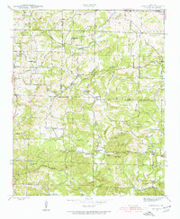
 1962 Agnos1963 Print · USGSNorthern Arkansas at the start of the 1960s shows a landscape of ridge-top settlements and winding river forks. Genealogists and local historians can locate rural landmarks like Burks Chapel, follow U.S. Route 62 through Agnos, or find family burial plots at Rhoads Cem.3 unique versions available
 - 1964 Map of Russellville
 1964 Russellville1964 Print · USGSMid-century Central Arkansas is defined here by the river-valley towns and the surrounding mountain ranges before the full expansion of the interstate system. Genealogists and historians can trace rail-town development along the Missouri Pacific Railroad and locate landmarks like Arkansas Polytechnic College or Petit Jean State Park.
 - 1964 Map of Harrison
 1964 Harrison1964 Print · USGSThe Ozark and Boston Mountains of Arkansas and Missouri are captured here in the mid-sixties, showing the rugged highlands before extensive modern development. Genealogists and historians can trace family-named peaks like Gaither Mountain and follow the St Louis-San Francisco RR through Monett and Purdy.
 - 1964 Map of Calico Rock, 1965 Print
 1964 Calico Rock1965 Print · USGSThe White River region at the height of the mid-sixties reveals a landscape of isolated river settlements and high Ozark ridges. Researchers can trace the river's impact through the Ghesmond Ferry and find family sites like the Old Optimus Cem or Bethel Springs Sch.4 unique versions available
 - 1964 Map of Pineville, 1965 Print
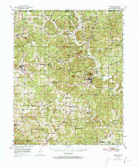
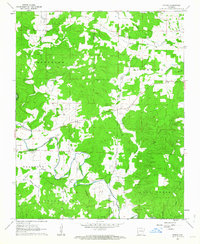
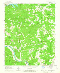
 1964 Pineville1965 Print · USGSOzark hill country in the mid-sixties is captured here, showing Izard County's winding creek valleys and upland townships. Genealogists and historians can trace family roots through landmarks like Potts Cem, Corinth Ch, and small crossroads settlements such as Wideman and Dolph.2 unique versions available
 - 1964 Map of Norfork Dam South, 1965 Print
 1964 Norfork Dam South1965 Print · USGSThe Ozark highlands of Baxter and Izard counties come alive in the mid-1960s as the White River winds through deep forest. Genealogists and historians can trace the Missouri Pacific rail line past Old Joe to the riverside town of Calico Rock.4 unique versions available
 - 1964 Map of Boswell, 1965 Print
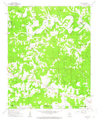
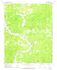 1964 Boswell1965 Print · USGSThe White River loops through the Ozarks in the mid-1960s, marking the boundary between Stone and Izard counties. Genealogists can trace family names at Mount Olive Cem and Optimus Cem or locate the old Missouri Pacific line at Boswell.4 unique versions available
Showing maps 1-25 of 52
Top cities of Izard County
- Horseshoe Bend historical maps
- Melbourne historical maps
- Calico Rock historical maps
- Oxford historical maps
- Mount Pleasant historical maps
- Pineville historical maps
See more
Frequently asked questions
- What are the different types of historical maps available for Izard County?
- What is the oldest map of Izard County?
- Where can I purchase historical maps of Izard County for my home or office?
- Where can I download high-res historical maps of Izard County?
- Are there historical topographic maps available for Izard County?
- Is there historical aerial imagery available for Izard County?
- Where are historical maps of Izard County sourced from?