1970s Maps of Izard County, Arkansas
Explore 7 historic maps of Izard County from the 1970s. These maps offer a rare glimpse into what life looked like during the 1970s — showing old roads, neighborhoods, homes, and landmarks that have changed or disappeared over time.
Whether you're researching your family's past, planning a metal detecting trip, or studying how Izard County's landscape evolved across the 1970s, these high-resolution maps are a powerful tool for exploring the history of this region.
- Focus on a specific era: All maps on this page are from the 1970s, giving you a focused view of this time period.
- See what’s changed: Compare century-old streets, trails, and buildings to today's modern landscape using overlays and satellite layers.
- Research with precision: Use these maps for genealogy, historical research, land use analysis, or educational projects.
- View, download, or print: Maps are fully viewable online in high resolution, and can be downloaded or printed for your own records.
Start exploring Izard County's history through authentic maps from the 1970s. This is your window into the past.
Izard County, AR maps
(7)- 1976 Map of Salem SW, 1977 Print
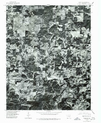 1976 Salem SW1977 Print · USGSMid-seventies Fulton County comes into focus in this detailed orthophotoquad, showing the rural crossroads and river valleys as they were decades ago. Trace the settlement patterns at Bexar and Union, or follow the winding course of the Strawberry River.
 - 1976 Map of Melbourne NE, 1977 Print
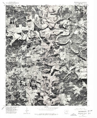 1976 Melbourne NE1977 Print · USGSMid-century Arkansas comes into sharp focus in this aerial survey of the Ozark foothills during the seventies. Local researchers can trace the exact boundaries of farms and homesteads near Wiseman and Violet Hill or follow the path of the Strawberry River.
 - 1976 Map of Salem SE, 1977 Print
 1976 Salem SE1977 Print · USGSThe northern Arkansas landscape comes into focus in the mid-1970s through this aerial orthophotoquad. Local historians can trace the rural layout of Salem and Wheeling or study the natural course of the South Fork Spring River.
 - 1976 Map of Melbourne NW, 1977 Print
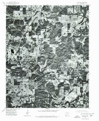
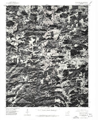
 1976 Melbourne NW1977 Print · USGSIzard County's rural landscape is captured through aerial photography in the mid-1970s, revealing the mid-century layout of timber and farmland. You can trace the development of Oxford and the winding path of the Strawberry River.
 - 1976 Map of Melbourne SW, 1977 Print
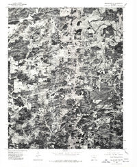
 1976 Melbourne SW1977 Print · USGSThe Ozark plateau around the county seat of Izard County is captured here in the mid-seventies just as the landscape was being documented through aerial orthophotography. Trace the development of Melbourne and the surrounding woodland clearings exactly as they were recorded during this 1976 winter flight.
 - 1977 Map of Russellville
 1977 Russellville1977 Print · USGSThe Arkansas River Valley and surrounding Ozark Mountains are documented here during a period of significant postwar growth and infrastructure development. Genealogists and researchers can locate family landmarks such as Mount Carmel Cem, St Josephs Church, and several remote Coal Mine sites along the Missouri Pacific RR line.
 - 1979 Map of Norfork Dam North, 1981 Print
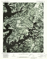 1979 Norfork Dam North1981 Print · USGSIn the late seventies, the complex shoreline of Norfork Lake and the surrounding Baxter County highlands are captured in sharp detail. Researchers can trace land use patterns near Henderson and Ruth or follow the winding course of Big Creek.
End of results
Showing maps 1-7 of 7
Top cities of Izard County
- Horseshoe Bend historical maps
- Melbourne historical maps
- Calico Rock historical maps
- Oxford historical maps
- Mount Pleasant historical maps
- Pineville historical maps
See more
Frequently asked questions
- What are the different types of historical maps available for Izard County?
- What is the oldest map of Izard County?
- Where can I purchase historical maps of Izard County for my home or office?
- Where can I download high-res historical maps of Izard County?
- Are there historical topographic maps available for Izard County?
- Is there historical aerial imagery available for Izard County?
- Where are historical maps of Izard County sourced from?