1950s Maps of Izard County, Arkansas
Explore 10 historic maps of Izard County from the 1950s. These maps offer a rare glimpse into what life looked like during the 1950s — showing old roads, neighborhoods, homes, and landmarks that have changed or disappeared over time.
Whether you're researching your family's past, planning a metal detecting trip, or studying how Izard County's landscape evolved across the 1950s, these high-resolution maps are a powerful tool for exploring the history of this region.
- Focus on a specific era: All maps on this page are from the 1950s, giving you a focused view of this time period.
- See what’s changed: Compare century-old streets, trails, and buildings to today's modern landscape using overlays and satellite layers.
- Research with precision: Use these maps for genealogy, historical research, land use analysis, or educational projects.
- View, download, or print: Maps are fully viewable online in high resolution, and can be downloaded or printed for your own records.
Start exploring Izard County's history through authentic maps from the 1950s. This is your window into the past.
Izard County, AR maps
(10)- 1950 Map of Salem, 1973 Print
 1950 Salem1973 Print · USGSFulton County and the surrounding Ozark borderlands are captured here in the mid-twentieth century, centered on the community of Salem. Local researchers can locate family homesteads near landmarks like Wesley Chapel, Bexar, and the Liberty Hill Ch.2 unique versions available
 - 1951 Map of Salem
 1951 Salem1951 Print · USGSFulton County settlements and timberlands are mapped here in detail during the early fifties. Genealogists and local historians can trace family roots through numerous sites like Wesley Chapel, Crossroads Sch, and the Hunter Cem.
 - 1951 Map of Melbourne, 1952 Print
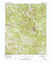
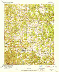 1951 Melbourne1952 Print · USGSIzard County in the early fifties is captured here as a landscape of interconnected ridge-top farms and creek-bottom hamlets. Researchers can trace ancestral roots at Philadelphia Ch, find the old Oxford Lookout Tower, or locate early settlements like Lunenburg and La Crosse.2 unique versions available
 - 1953 Map of Memphis, 1966 Print
 1953 Memphis1966 Print · USGSEastern Arkansas and the Memphis riverfront are shown here during the mid-century period of regional growth and river management. Local historians can trace the paths of the Chicago Rock Island & Pacific RR through Forrest City or locate river landmarks like President's Island.3 unique versions available
 - 1954 Map of Harrison
 1954 Harrison1954 Print · USGSThe Ozarks and Boston Mountains meet during a period of massive river engineering in the mid-fifties. Researchers can trace the early shorelines of Bull Shoals Lake and Table Rock Reservoir or locate inland towns like Berryville and Harrison.
 - 1956 Map of Memphis
 1956 Memphis1956 Print · USGSThe Mississippi Delta and the bluffs of West Tennessee meet in the mid-fifties, showing a landscape defined by massive river systems and rail hubs. Researchers can trace the path of Crowleys Ridge or locate vanished river landings near Centennial Island and Island No 35.
 - 1956 Map of Russellville
 1956 Russellville1956 Print · USGSThe Arkansas River valley and the surrounding Boston Mountains are captured here in the mid-fifties, showing a landscape of small timber towns and new reservoirs. Genealogists can trace family roots through upland settlements like Pelsor and Witts Springs or locate the campus of Arkansas Polytechnic College.2 unique versions available
 - 1957 Map of Poplar Bluff, 1968 Print
 1957 Poplar Bluff1968 Print · USGSThe Missouri-Arkansas border region is captured here as the timber and rail industries shaped the Ozark foothills. Genealogists and historians can trace the Missouri Pacific Railroad through river towns like Pocahontas, Greenville, and Van Buren.3 unique versions available
 - 1958 Map of Harrison, 1973 Print
 1958 Harrison1973 Print · USGSThe Ozark and Boston Mountains appear in this mid-century survey as the great White River impoundments were reshaping the region. Researchers can trace the rail lines of the St Louis-San Francisco Ry and locate early settlements like Berryville and Gainesville.
 - 1959 Map of Poplar Bluff
 1959 Poplar Bluff1959 Print · USGSThe Missouri Ozarks and Arkansas borderlands meet in this late 1950s study of the region's diverse terrain and rail-fed towns. Researchers can trace the path of the Missouri Pacific Railroad through Poplar Bluff or locate smaller settlements like Birch Tree and Myrtle.
End of results
Showing maps 1-10 of 10
Top cities of Izard County
- Horseshoe Bend historical maps
- Melbourne historical maps
- Calico Rock historical maps
- Oxford historical maps
- Mount Pleasant historical maps
- Pineville historical maps
See more
Frequently asked questions
- What are the different types of historical maps available for Izard County?
- What is the oldest map of Izard County?
- Where can I purchase historical maps of Izard County for my home or office?
- Where can I download high-res historical maps of Izard County?
- Are there historical topographic maps available for Izard County?
- Is there historical aerial imagery available for Izard County?
- Where are historical maps of Izard County sourced from?