1980s Maps of Izard County, Arkansas
Explore 15 historic maps of Izard County from the 1980s. These maps offer a rare glimpse into what life looked like during the 1980s — showing old roads, neighborhoods, homes, and landmarks that have changed or disappeared over time.
Whether you're researching your family's past, planning a metal detecting trip, or studying how Izard County's landscape evolved across the 1980s, these high-resolution maps are a powerful tool for exploring the history of this region.
- Focus on a specific era: All maps on this page are from the 1980s, giving you a focused view of this time period.
- See what’s changed: Compare century-old streets, trails, and buildings to today's modern landscape using overlays and satellite layers.
- Research with precision: Use these maps for genealogy, historical research, land use analysis, or educational projects.
- View, download, or print: Maps are fully viewable online in high resolution, and can be downloaded or printed for your own records.
Start exploring Izard County's history through authentic maps from the 1980s. This is your window into the past.
Izard County, AR maps
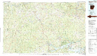
(15)- 1983 Map of Cherokee Village
 1983 Cherokee Village1983 Print · USGSThe Ozark foothills and river valleys of Northeast Arkansas are captured in the early eighties as modern planned communities began to reshape the landscape. Genealogists and historians can trace family-named ridges and schools across Evening Shade, Melbourne, and the rail junction at Hoxie.
 - 1983 Map of Mountain View
 1983 Mountain View1983 Print · USGSNorth-central Arkansas comes into sharp focus during the early eighties, showing the transition from traditional Ozark mountain settlements to a landscape shaped by major reservoirs. Genealogists and historians can trace family roots through mountain hamlets like Snowball, Witts Springs, and Timbo, or locate landmarks such as Zion Hill Church and the Missouri Pacific Railroad.
 - 1984 Map of Zion
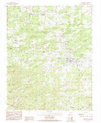
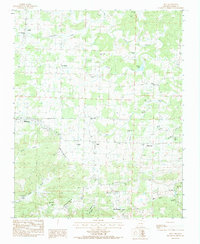 1984 Zion1984 Print · USGSIzard County in the early 1980s reveals a landscape of dispersed family settlements and country parishes connected by timbered ridges and creek valleys. Genealogists can trace local heritage through sites like Old Philadelphia Cem, Bethlehem Cem, and the rural community of Bone Town.
 - 1984 Map of Byron
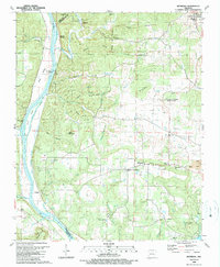
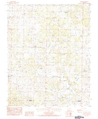 1984 Byron1984 Print · USGSThe rural Arkansas borderlands of Fulton and Izard Counties are captured in the early eighties, showcasing a landscape of dispersed farmsteads and small crossroads. Genealogists can trace family footprints at Liberty Cem, Harmony Cem, and the quiet community of Byron.
 - 1984 Map of Franklin
 1984 Franklin1984 Print · USGSNorth Central Arkansas in the early eighties shows a landscape of river-valley settlements and growing recreational hubs. Genealogists and historians can trace family sites at Old Liberty Cem, locate the rural community of Violet Hill, or study the development of Horseshoe Bend.
 - 1984 Map of Salem
 1984 Salem1984 Print · USGSNorth central Arkansas in the early eighties centers on the town of Salem, a landscape of winding Ozark creeks and small crossroads communities. Local historians can trace family roots through the settlements of Wheeling and Morriston or locate specific landmarks like Wheeler Spring and Pinhook Bend.
 - 1984 Map of Russellville
 1984 Russellville1984 Print · USGSThe Arkansas River valley was undergoing significant change in the 1950s as transportation and water management reshaped the region from Russellville to Conway. Researchers can trace the era's rail networks like the Missouri Pacific RR and explore landmarks like Magazine Mountain and Petit Jean State Park.
 - 1984 Map of Melbourne
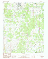
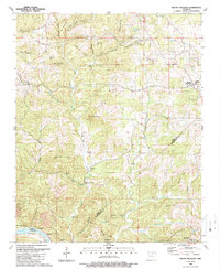
 1984 Melbourne1984 Print · USGSThe Izard County seat of Melbourne is documented here in the early 1980s, surrounded by the foothills of Bald Mountain. Genealogists can trace family landmarks like Page Cem and Lawrence Cem or the small settlements of Newburg and Lunenburg.
 - 1984 Map of Oxford
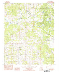
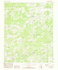 1984 Oxford1984 Print · USGSOzark foothills in Izard County come into focus during the early eighties, showing a landscape of dispersed settlements and winding creeks. Genealogists can locate family burial sites at Blankenship Cem and Owens Cem or trace the rural roads connecting Oxford to Band Mill.
 - 1985 Map of Bull Shoals Lake
 1985 Bull Shoals Lake1985 Print · USGSThe mid-1980s Ozark Plateau is captured here during a era of significant growth around the sprawling shorelines of Bull Shoals Lake and Norfork Lake. Genealogists and historians can trace the rail-and-river economy through Buffalo City and the Missouri Pacific RR line.
 - 1985 Map of Harrison
 1985 Harrison1985 Print · USGSThe Ozark highlands and the White River valley are seen here in the mid-1980s, showcasing a region defined by its massive reservoirs and protected wilderness. You can trace the rugged corridors of the Missouri & North Arkansas RR or locate historic settlements like Eureka Springs and Jasper.
 - 1986 Map of Batesville
 1986 Batesville1986 Print · USGSNorth-central Arkansas in the mid-eighties shows a landscape of river-bend towns and Ozark foothills during a period of steady growth. You can trace family roots through numerous upland sites like Hickory Valley School, Sandtown Hill Cem, and the riverfront at Oil Trough.2 unique versions available
 - 1989 Map of Bethesda
 1989 Bethesda1989 Print · USGSIn the late 1980s, the rural hills of Independence County remained a landscape of tight-knit communities and river-fed industry. Researchers can trace the roots of local families at Bethesda, locate historical congregations like Chinquapin Ch, and find the river-side Biltmore Siding.
 - 1989 Map of Mount Pleasant
 1989 Mount Pleasant1989 Print · USGSThe hill country of Izard and Independence counties comes into focus in the late eighties, documenting the rural settlements and caves north of the White River. Genealogists can locate several remote burial grounds like No Bottom Cem and Winkle Cem, alongside community landmarks such as Macedonia Ch.
 - 1989 Map of Sandtown, 1990 Print
 1989 Sandtown1990 Print · USGSThe hill country of North-Central Arkansas is captured here in the late 1980s, where three counties meet among deep hollows and creek branches. Genealogists and local historians can trace family roots through numerous remote sites like Mt Carmel Cem, St Pauls Ch, and the settlement of Sandtown.
End of results
Showing maps 1-15 of 15
Top cities of Izard County
- Horseshoe Bend historical maps
- Melbourne historical maps
- Calico Rock historical maps
- Oxford historical maps
- Mount Pleasant historical maps
- Pineville historical maps
See more
Frequently asked questions
- What are the different types of historical maps available for Izard County?
- What is the oldest map of Izard County?
- Where can I purchase historical maps of Izard County for my home or office?
- Where can I download high-res historical maps of Izard County?
- Are there historical topographic maps available for Izard County?
- Is there historical aerial imagery available for Izard County?
- Where are historical maps of Izard County sourced from?