1960s Maps of Jackson County, Arkansas
Explore 15 historic maps of Jackson County from the 1960s. These maps offer a rare glimpse into what life looked like during the 1960s — showing old roads, neighborhoods, homes, and landmarks that have changed or disappeared over time.
Whether you're researching your family's past, planning a metal detecting trip, or studying how Jackson County's landscape evolved across the 1960s, these high-resolution maps are a powerful tool for exploring the history of this region.
- Focus on a specific era: All maps on this page are from the 1960s, giving you a focused view of this time period.
- See what’s changed: Compare century-old streets, trails, and buildings to today's modern landscape using overlays and satellite layers.
- Research with precision: Use these maps for genealogy, historical research, land use analysis, or educational projects.
- View, download, or print: Maps are fully viewable online in high resolution, and can be downloaded or printed for your own records.
Start exploring Jackson County's history through authentic maps from the 1960s. This is your window into the past.
Jackson County, AR maps
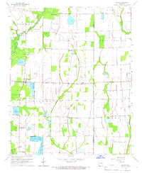
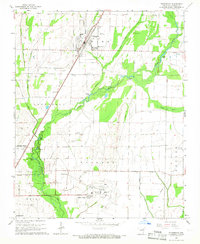
(15)- 1962 Map of Jacksonport, 1963 Print
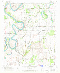
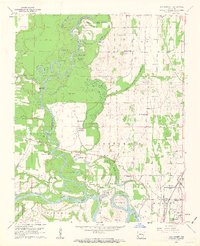 1962 Jacksonport1963 Print · USGSThe confluence of the Black and White Rivers in the early 1960s highlights a landscape of oxbows and riverfront history. Researchers can locate numerous family cemeteries such as Holloway Cem and Mercy Seat Cem, or trace the MISSOURI PACIFIC line through Campbell Station.3 unique versions available
 - 1962 Map of Olyphant, 1963 Print
 1962 Olyphant1963 Print · USGSIndependence and Jackson counties are captured here in the early sixties as the rail-side community of Olyphant and rural settlements like Thida anchored the landscape. Genealogists can trace family names at Lone Beech Cem and Sanders Cem or locate the local Blackland Chapel.2 unique versions available
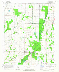
 - 1962 Map of Newport, 1963 Print
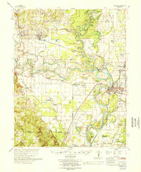
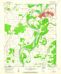 1962 Newport1963 Print · USGSJackson and Independence counties are captured here in the early sixties, centered on the riverfront development of Newport. Researchers can trace local genealogy and rural life through landmarks like Nuckles Switch Cem, Castleberry Sch, and the abandoned airport.3 unique versions available
 - 1962 Map of Newport, 1967 Print
 1962 Newport1967 Print · USGSThe Arkansas Delta comes to life in the early sixties, showing the river-dominated landscape of Jackson and Independence Counties. Researchers can trace family sites at Elgin Landmark Ch or follow the Missouri Pacific rails through Oil Trough and Newport.
 - 1965 Map of Amagon, 1966 Print
 1965 Amagon1966 Print · USGSNortheast Arkansas in the mid-sixties is captured here as a landscape of managed wetlands and small rural communities. Genealogists can locate family burial sites at Carter Cem and Johnson Cem or trace the early industrial footprint of Stringers Mill.
 - 1965 Map of Grubbs, 1966 Print
 1965 Grubbs1966 Print · USGSNear the Cache River in the mid-1960s, this area of Jackson County shows a landscape of engineered drainage and small farming outposts. Researchers can locate several remote burial grounds and churches, including Denton Island Cem, Hollows Chapel, and the settlement of Grubbs.
 - 1965 Map of Huff, 1966 Print
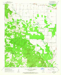
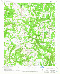
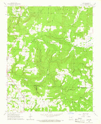 1965 Huff1966 Print · USGSThe rural interior of northern Arkansas comes into focus in the mid-1960s as these hillsides transitioned from traditional farming toward modern infrastructure. Genealogists and historians can trace family locations near Huff Cem, Midway, and Sunnyside Ch.2 unique versions available
 - 1965 Map of Auvergne, 1966 Print
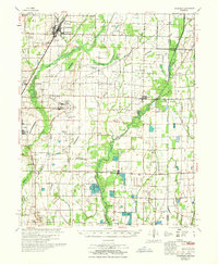
 1965 Auvergne1966 Print · USGSJackson County's river bottoms were a maze of sloughs and timbered tracts in the mid-1960s. Genealogists and historians can trace family locations through sites like Odd Fellows Cem, Rutherford Sch, and the quiet community of Auvergne.2 unique versions available
 - 1965 Map of Tuckerman, 1966 Print
 1965 Tuckerman1966 Print · USGSJackson County's agricultural heartland is captured here in the mid-1960s, showing the vital rail and water networks connecting the region. Researchers can trace family history through numerous landmarks like Gracelawn Cem, Eastside Sch, and the community at Campbell Station.2 unique versions available
 - 1965 Map of Velvet Ridge, 1966 Print
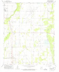
 1965 Velvet Ridge1966 Print · USGSWhite and Jackson County family lands are surveyed here in the mid-sixties as small rural communities like Velvet Ridge and Denmark thrived. Researchers can find several burial sites and churches, including Bethlehem Cem, Smith Cem, and Mt Carmel Ch.2 unique versions available
 - 1966 Map of Newport
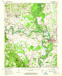
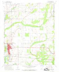
 1966 Newport1966 Print · USGSThe White River meanders through Jackson and Independence counties in the mid-sixties, revealing a network of river-bend settlements and rail hubs. Researchers can trace historic church sites like Mt Zion Ch, family cemeteries such as Salem Cem, and the industrial pulse of Newport and Newark.
 - 1967 Map of Tuckerman
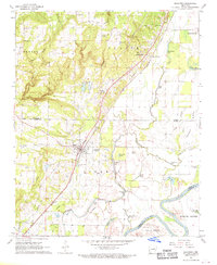
 1967 Tuckerman1967 Print · USGSThe Jackson County lowlands are captured here in the mid-sixties, showing a landscape defined by the Cache River and its sloughs. Trace family history at Gracelawn Cem, find old school sites like Eastside Sch, and locate industrial landmarks like Stringers Mill.
 - 1967 Map of Augusta NE, 1969 Print
 1967 Augusta NE1969 Print · USGSThe Arkansas bottomlands along the Jackson and Woodruff county lines appear in the late 1960s as a maze of river oxbows and levees. Researchers can locate vanished landmarks like Spriggs Mill and Old Grand Glaise, or trace family roots near White Lake Ch.
 - 1968 Map of Augusta, 1969 Print
 1968 Augusta1969 Print · USGSWoodruff County, Arkansas, appears in the late sixties as a thriving river-and-rail landscape centered on the historic seat of Augusta. Genealogists and local historians can trace family sites at Mt Olive Cem, Union, and the Carver Sch during this era of regional growth.2 unique versions available
 - 1968 Map of Bradford, 1970 Print
 1968 Bradford1970 Print · USGSThe rail-and-river corridor of White County is frozen in time during the late sixties, showcasing the area's transition from ridge to bottomland. Researchers can locate family landmarks like McKnight Cem or trace the early settlements of Old Grand Glaise and Possum Grape.2 unique versions available
End of results
Showing maps 1-15 of 15
Top cities of Jackson County
- Newport historical maps
- Tuckerman historical maps
- Diaz historical maps
- Swifton historical maps
- Grubbs historical maps
- Campbell Station historical maps
See more
Frequently asked questions
- What are the different types of historical maps available for Jackson County?
- What is the oldest map of Jackson County?
- Where can I purchase historical maps of Jackson County for my home or office?
- Where can I download high-res historical maps of Jackson County?
- Are there historical topographic maps available for Jackson County?
- Is there historical aerial imagery available for Jackson County?
- Where are historical maps of Jackson County sourced from?