1970s Maps of Lee County, Arkansas
Explore 9 historic maps of Lee County from the 1970s. These maps offer a rare glimpse into what life looked like during the 1970s — showing old roads, neighborhoods, homes, and landmarks that have changed or disappeared over time.
Whether you're researching your family's past, planning a metal detecting trip, or studying how Lee County's landscape evolved across the 1970s, these high-resolution maps are a powerful tool for exploring the history of this region.
- Focus on a specific era: All maps on this page are from the 1970s, giving you a focused view of this time period.
- See what’s changed: Compare century-old streets, trails, and buildings to today's modern landscape using overlays and satellite layers.
- Research with precision: Use these maps for genealogy, historical research, land use analysis, or educational projects.
- View, download, or print: Maps are fully viewable online in high resolution, and can be downloaded or printed for your own records.
Start exploring Lee County's history through authentic maps from the 1970s. This is your window into the past.
Lee County, AR maps
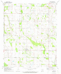
(9)- 1971 Map of Wheatley, 1973 Print
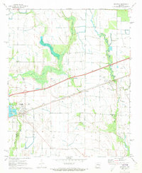 1971 Wheatley1973 Print · USGSWheatley and the surrounding St. Francis County wetlands are captured here in the early seventies as modern transit intersected traditional farm life. Genealogists can trace family names and community ties through sites like Monroe Academy, Pilgrim Rest Cem, and the cluster of Goodwin Cems.
 - 1971 Map of Monroe, 1973 Print
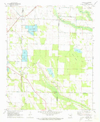 1971 Monroe1973 Print · USGSThe Arkansas Delta comes into focus in the early 1970s at the intersection of three counties, where the Louisiana Purchase Monument stands. Trace the development of local aquaculture and rural settlements like Monroe, Blackton, and Macedonia Ch.
 - 1971 Map of Aubrey, 1973 Print
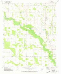 1971 Aubrey1973 Print · USGSThe Arkansas Delta comes into focus in the early 1970s, showing a landscape of fertile lowlands and scattered crossroads. Researchers can trace rural lineages through sites like Turkey Scratch, Holland Cemetery, and the Lee County Church.
 - 1971 Map of Garrett Grove, 1973 Print
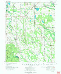
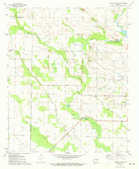 1971 Garrett Grove1973 Print · USGSThe Arkansas Delta comes into focus in the early seventies, detailing the rural intersections of Lee and Monroe counties. Researchers can trace family history through sites like Bemis Plantation, Moro Temple, and several local cemeteries including Long Cane Cemetery.
 - 1971 Map of Rondo, 1973 Print
 1971 Rondo1973 Print · USGSEastern Arkansas at the start of the 1970s reveals a deep network of delta communities tied to the land and the local parish. Researchers can trace the path of an Old Railroad Grade and locate numerous rural landmarks like Possum Trot Cem and St Holmes Ch.
 - 1974 Map of Holly Grove
 1974 Holly Grove1974 Print · USGSEastern Arkansas at the start of the 1970s reveals a landscape of specialized aquaculture and historic survey points. Genealogists and historians can trace numerous rural congregations and burial sites like Big Star Ch, Postelle Cem, and the Louisiana Purchase Monument.
 - 1975 Map of Horseshoe Lake NW, 1976 Print
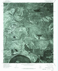 1975 Horseshoe Lake NW1976 Print · USGSThe Arkansas Delta near the Mississippi border comes into sharp focus in the mid-1970s, revealing a landscape of oxbow lakes and precision farming. Genealogists and local historians can trace the street layouts of Hughes and locate the rural settlement of Penjur near Council Lake.
 - 1975 Map of Clayton NW, 1976 Print
 1975 Clayton NW1976 Print · USGSThe Mississippi Delta landscape comes into focus in the mid-1970s, revealing the intricate patterns of agriculture and river movement. Researchers can trace the layout of small communities like Austin and Evansville or explore the banks of Beaverdam Lake.
 - 1975 Map of Horseshoe Lake SW, 1976 Print
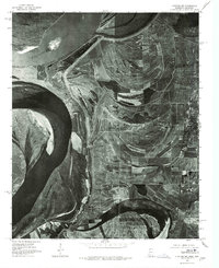
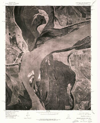 1975 Horseshoe Lake SW1976 Print · USGSThe winding Mississippi River forms the state line in the mid-1970s, revealing a landscape of active river dynamics and floodplain farming. Genealogists and researchers can locate riverfront settlements like Council, Happy, and Commerce.
End of results
Showing maps 1-9 of 9
Top cities of Lee County
- Marianna historical maps
- Moro historical maps
- Rondo historical maps
- Haynes historical maps
- Aubrey historical maps
- LaGrange historical maps
Frequently asked questions
- What are the different types of historical maps available for Lee County?
- What is the oldest map of Lee County?
- Where can I purchase historical maps of Lee County for my home or office?
- Where can I download high-res historical maps of Lee County?
- Are there historical topographic maps available for Lee County?
- Is there historical aerial imagery available for Lee County?
- Where are historical maps of Lee County sourced from?