1970s Maps of Little Garnett, Arkansas
Explore 3 historic maps of Little Garnett from the 1970s. These maps offer a rare glimpse into what life looked like during the 1970s — showing old roads, neighborhoods, homes, and landmarks that have changed or disappeared over time.
Whether you're researching your family's past, planning a metal detecting trip, or studying how Little Garnett's landscape evolved across the 1970s, these high-resolution maps are a powerful tool for exploring the history of this region.
- Focus on a specific era: All maps on this page are from the 1970s, giving you a focused view of this time period.
- See what’s changed: Compare century-old streets, trails, and buildings to today's modern landscape using overlays and satellite layers.
- Research with precision: Use these maps for genealogy, historical research, land use analysis, or educational projects.
- View, download, or print: Maps are fully viewable online in high resolution, and can be downloaded or printed for your own records.
Start exploring Little Garnett's history through authentic maps from the 1970s. This is your window into the past.
Little Garnett, AR maps
(3)- 1973 Map of Relfs Bluff, 1975 Print
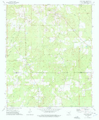 1973 Relfs Bluff1975 Print · USGSSoutheast Arkansas in the mid-1970s was a landscape of timber, gravel, and quiet country crossroads along the Lincoln and Drew County line. Genealogists and historians can trace family locations near Relfs Bluff, Mountain Home Ch, and the Maxwell Cem.
 - 1975 Map of Lonoke SE, 1977 Print
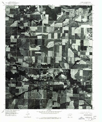 1975 Lonoke SE1977 Print · USGSPrairie farmlands and wooded drainages define this mid-1970s aerial survey just outside of the regional hub. Genealogists and local historians can trace land use patterns and road networks as they existed decades ago near Carlisle.
 - 1978 Map of Star City
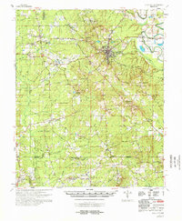 1978 Star City1978 Print · USGSThe rural landscapes of Lincoln and Cleveland counties are captured here in the late seventies, centered on the hub of Star City. Genealogists can trace family names and local landmarks through sites like Strangers Rest Ch, Bush Cem, and the old settlement at Feenyville.
End of results
Showing maps 1-3 of 3
Top cities near Little Garnett
Frequently asked questions
- What are the different types of historical maps available for Little Garnett?
- What is the oldest map of Little Garnett?
- Where can I purchase historical maps of Little Garnett for my home or office?
- Where can I download high-res historical maps of Little Garnett?
- Are there historical topographic maps available for Little Garnett?
- Is there historical aerial imagery available for Little Garnett?
- Where are historical maps of Little Garnett sourced from?