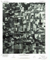
1975 Map of Lonoke SE
USGS Topo · Published 1977About this map
Agricultural patterns dominate this 1975 orthophotoquad, which uses aerial photography to capture the landscape surrounding the western outskirts of Carlisle. The imagery reveals a complex patchwork of cultivated fields and wooded drainages typical of the Arkansas Grand Prairie region. Because this is an orthophotograph rather than a traditional line-drawn topographic map, the view provides a direct visual record of the 1970s land use, showing the exact footprint of farmsteads, access roads, and forest lines during the mid-decade. The rectilinear grid of the local road network and the prominent paths of state and interstate highways bisect the rural terrain, illustrating the connectivity between local farm operations and the regional center of Carlisle.
Find a feature on this map
1 named feature on this map. Tap any name to fly to it.
Don’t see what you’re looking for? This feature index may not catch every label — zoom into the map to look around manually.
Map Details
Editions of this 1975 Lonoke SE Map
This is the sole edition of this map. No revisions or reprints were ever made.
Other maps of this area

1935 · Feenyville
USGS Topo · 1:62,500

1935 · Cominto
USGS Topo · 1:62,500

1935 · Rotan
USGS Topo · 1:62,500

1953 · Greenwood
USGS Topo · 1:250,000

1956 · Greenwood
USGS Topo · 1:250,000

1960 · Collins NW
USGS Topo · 1:24,000

1960 · Collins
USGS Topo · 1:62,500
1964 · Avery
USGS Topo · 1:24,000
1964 · Tyro
USGS Topo · 1:24,000

1966 · Monticello North
USGS Topo · 1:24,000