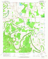
1964 Map of Avery
USGS Topo · Published 1965About this map
Bartholomew Bayou meanders deeply through this Lincoln County landscape, defining the agricultural and hydrological character of the region in the mid-1960s. The map reveals a dense network of country churches and schools that served the small agricultural communities of Avery, Meroney, and Fresno. Significant cultural landmarks like the Indian Mounds near Avery Brake sit alongside more modern developments such as the Fish Hatchery and numerous reservoirs like Pinchback Reservoir. The survey captures a moment when local infrastructure was heavily influenced by the terrain, with Persons Bridge crossing the bayou and multiple sloughs such as Deep Slough and Panther Slough cutting through the fields. For those researching family history, the placement of Wells Bayou Sch and small cemeteries like Mackwee Cem provides precise locations for long-standing community centers in this rural Arkansas Delta environment.
Find a feature on this map
37 named features on this map. Tap any name to fly to it.
Don’t see what you’re looking for? This feature index may not catch every label — zoom into the map to look around manually.
Map Details
Editions of this 1964 Avery Map
2 editions found
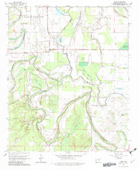
Other maps of this area

1935 · Feenyville
USGS Topo · 1:62,500

1935 · Varner
USGS Topo · 1:62,500

1935 · Noble Lake
USGS Topo · 1:62,500

1935 · Rotan
USGS Topo · 1:62,500

1948 · Helena
USGS Topo · 1:250,000

1950 · Helena
USGS Topo · 1:250,000

1953 · Greenwood
USGS Topo · 1:250,000

1955 · Helena
USGS Topo · 1:250,000

1956 · Greenwood
USGS Topo · 1:250,000

1959 · Helena
USGS Topo · 1:250,000