1980s Maps of Keo, Arkansas
Explore 5 historic maps of Keo from the 1980s. These maps offer a rare glimpse into what life looked like during the 1980s — showing old roads, neighborhoods, homes, and landmarks that have changed or disappeared over time.
Whether you're researching your family's past, planning a metal detecting trip, or studying how Keo's landscape evolved across the 1980s, these high-resolution maps are a powerful tool for exploring the history of this region.
- Focus on a specific era: All maps on this page are from the 1980s, giving you a focused view of this time period.
- See what’s changed: Compare century-old streets, trails, and buildings to today's modern landscape using overlays and satellite layers.
- Research with precision: Use these maps for genealogy, historical research, land use analysis, or educational projects.
- View, download, or print: Maps are fully viewable online in high resolution, and can be downloaded or printed for your own records.
Start exploring Keo's history through authentic maps from the 1980s. This is your window into the past.
Keo, AR maps
(5)- 1982 Map of England
 1982 England1982 Print · USGSThe rural landscapes of Lonoke County are meticulously documented here in the early eighties, centered on the railroad town of England. Researchers can trace old family roots at Mulberry Cem, Tomberlin Cem, and country congregations like Union Valley Ch.
 - 1985 Map of Little Rock, 1988 Print
 1985 Little Rock1988 Print · USGSLittle Rock and its surrounding river valley are shown in the mid-eighties as the region balanced urban expansion with its industrial and military roots. Genealogists and historians can locate dozens of institutions and family landmarks, including Mount Holly Cem, the Bauxite Mines, and Central High Sch.
 - 1986 Map of Brinkley
 1986 Brinkley1986 Print · USGSThe Grand Prairie and White River basin come to life in the mid-1980s, showing the intersection of heavy rail and interstate travel through eastern Arkansas. Genealogists can locate family sites near Sylvania Cem, Oak Grove Ch, and the rural community of De Valls Bluff.
 - 1987 Map of Keo
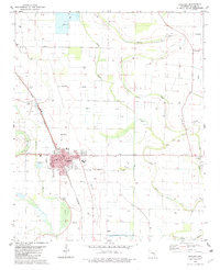
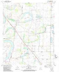
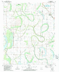 1987 Keo1987 Print · USGSThe Lonoke and Pulaski county lines meet in this agricultural corridor during the late eighties, where rail and water dictate the landscape. Researchers can trace rural life through landmarks like Alexander Cem, the St Louis Southwestern tracks in Keo, and Millers Chapel.
 - 1987 Map of Scott
 1987 Scott1987 Print · USGSThe Arkansas River bottomlands in the late eighties reveal a landscape of oxbow lakes, ancient earthworks, and rural rail stops. Genealogists and historians can locate family landmarks like Walkers Corner, Le Grande Cem, and the notable Toltec Mounds State Park.
End of results
Showing maps 1-5 of 5
Top cities near Keo
- Little Rock historical maps
- North Little Rock historical maps
- Jacksonville historical maps
- Sherwood historical maps
- Lonoke historical maps
- England historical maps
See more
Top neighborhoods of Keo
Frequently asked questions
- What are the different types of historical maps available for Keo?
- What is the oldest map of Keo?
- Where can I purchase historical maps of Keo for my home or office?
- Where can I download high-res historical maps of Keo?
- Are there historical topographic maps available for Keo?
- Is there historical aerial imagery available for Keo?
- Where are historical maps of Keo sourced from?