Old Maps of Keo, Arkansas for Academic Research
Study the evolution of Keo with 40 high-resolution historic maps. Whether you're teaching, researching, or modeling changes in land use, these maps provide essential visual documentation of urban, environmental, and geographic change.
- Analyze long-term change: Track patterns in development, transportation, and natural features.
- Ideal for environmental or urban studies: Support academic projects with primary historical map data.
- Use in the classroom or lab: Educators and researchers rely on these maps to bring historical context to life.
These maps are a powerful tool for teaching, research, and visualizing how Keo has changed over the decades.
Keo, AR maps
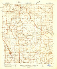
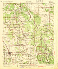
(40)- 1891 Map of Little Rock
 1891 Little Rock1891 Print · USGSLittle Rock and the central Arkansas river valley are shown in detail during the 1890s, when rail travel and river trade dominated the local economy. Genealogists can trace early homesteads and communities near Argenta, the Indian Mounds at Toltec, and Sweet Home.
 - 1893 Map of Little Rock
 1893 Little Rock1893 Print · USGSLittle Rock and the Arkansas River valley are shown here in the early 1890s, just as the regional rail network was maturing. Genealogists can trace family roots through old settlements like Argenta, Shilcott, and Collegeville, or locate archaeological sites such as the Indian Mounds.5 unique versions available
 - 1937 Map of England
 1937 England1937 Print · USGSThe Arkansas Delta south of Lonoke comes alive in the late 1930s, showing a landscape of small farming townships and dense rural school districts. Genealogists can trace family roots through numerous sites like Zion Chapel, Mulberry Cem, and the Macedonia Sch.3 unique versions available
 - 1939 Map of Keo
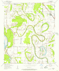
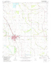
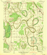 1939 Keo1939 Print · USGSThe Arkansas Delta comes alive in the late thirties as a network of rail-side settlements and oxbow lakes. Genealogists and local historians can trace the foundations of rural life through sites like Keo, Macedonia Chapel, and the St Louis Southwestern Railway.3 unique versions available
 - 1941 Map of Keo
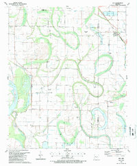
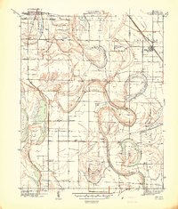 1941 Keo1941 Print · USGSThe river bottomlands of Lonoke and Pulaski County are revealed here just before the war, dominated by the serpentine curves of the Arkansas River. Genealogists can trace the rural community through numerous local landmarks like Paradise Ch, Millers Chapel, and the settlement at Wampoo.
 - 1942 Map of Scott
 1942 Scott1942 Print · USGSThe alluvial plains east of Little Rock come to life in this early 1940s survey of the Arkansas River oxbows. Researchers can pinpoint the Toltec Mounds and trace a dense network of country schools and churches like Banes Chapel Sch and Mt Hope Ch.2 unique versions available
 - 1943 Map of England
 1943 England1943 Print · USGSLonoke County comes into focus just before the mid-century, showing a landscape of delta farming communities and vital rail links. Trace family roots and vanished landmarks through a dense network of country schools and churches like Oldham Sch, Coy, and Zion Chapel.
 - 1948 Map of Helena
 1948 Helena1948 Print · USGSEastern Arkansas and the Mississippi Delta are captured here just after the war, showing a landscape defined by its great rivers and rail lines. Genealogists can trace family locations near Bemis Plantation, Helena, and smaller rail stops like Wheatley and Moro.
 - 1950 Map of Helena
 1950 Helena1950 Print · USGSMid-century Phillips County and the surrounding Delta region are shown at a peak of rail and river commerce. Genealogists and historians can trace family locations through numerous rural communities like Old Austin, Cotton Plant, and West Helena, or follow the routes of the Missouri Pacific RR across Grand Prairie.2 unique versions available
 - 1954 Map of Keo, 1957 Print
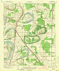
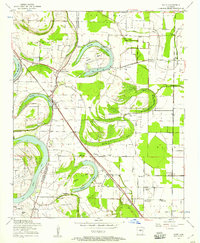
 1954 Keo1957 Print · USGSThe Arkansas River lowlands and the Lonoke-Pulaski county line come to life in the mid-1950s, showing a landscape of fertile bottoms and winding oxbows. Researchers can trace rural lineages through numerous landmarks like Estes Church, Bredlow Corner, and the Keo Cemetery.2 unique versions available
 - 1954 Map of Scott, 1957 Print
 1954 Scott1957 Print · USGSThe oxbows and river bends of the Arkansas lowlands are captured here in the mid-fifties, just as rural communities like Scott and Toltec were evolving. Researchers can trace ancestral footprints at Toltec Mounds, La Grande Cemetery, and old rural hubs like Walkers Corner.3 unique versions available
 - 1955 Map of Helena, 1967 Print
 1955 Helena1967 Print · USGSThe Arkansas Delta and Mississippi floodplains are captured here in the mid-fifties, during a period of expanding flood control and rail commerce. Researchers can trace the extensive Chicago Rock Island and Pacific RR lines and locate sites like the Arkansas State College Experimental Rice Farm or Friars Point.2 unique versions available
 - 1955 Map of Little Rock, 1978 Print
 1955 Little Rock1978 Print · USGSCentral Arkansas in the mid-fifties exhibits a landscape of growing cities, massive military installations, and mountain reservoirs. Genealogists and historians can trace the industrial Bauxite Mines, regional rail lines, and local landmarks like Antioch Church.
 - 1956 Map of Little Rock
 1956 Little Rock1956 Print · USGSCentral Arkansas in the mid-fifties shows a landscape defined by burgeoning military bases and the timber-and-mineral wealth of the Ouachitas. Genealogists and researchers can trace old rail lines like the Missouri Pacific and find established communities such as Bauxite, Sheridan, and Mabelvale.
 - 1959 Map of Helena
 1959 Helena1959 Print · USGSThe Arkansas and Mississippi Delta regions are captured here in the late fifties, showing a landscape defined by the Mississippi River and the Grand Prairie. Genealogists and researchers can trace the rail networks of the Illinois Central RR and locate community landmarks like Helena and the White River National Wildlife Refuge.
 - 1960 Map of Little Rock
 1960 Little Rock1960 Print · USGSCentral Arkansas in the late fifties shows a landscape of growing military bases and massive new reservoirs. Local historians can trace the mid-century expansion of Little Rock and Hot Springs alongside the industrial works at Bauxite and the Pine Bluff Arsenal.
 - 1960 Map of Helena
 1960 Helena1960 Print · USGSThe Arkansas and Mississippi Delta regions meet along the great river bends during a period of significant agricultural and rail expansion. Genealogists and historians can trace the paths of the Missouri Pacific railroad through Clarendon or locate landings along the Mississippi River and White River.
 - 1964 Map of Little Rock
 1964 Little Rock1964 Print · USGSCentral Arkansas in the mid-sixties is a landscape of mountain ridges, industrial rail lines, and growing military hubs. Researchers can trace the development of Bauxite and Hot Springs or locate rural landmarks like Sparkman and the Pine Bluff Arsenal.
 - 1975 Map of England SW, 1977 Print
 1975 England SW1977 Print · USGSIn the mid-1970s, the fertile Arkansas Delta around Lonoke County was a landscape of precision-cut fields and winding waterways. Researchers can trace the layout of England and identify rural landmarks along Bakers Bayou and near Coy.
 - 1982 Map of England
 1982 England1982 Print · USGSThe rural landscapes of Lonoke County are meticulously documented here in the early eighties, centered on the railroad town of England. Researchers can trace old family roots at Mulberry Cem, Tomberlin Cem, and country congregations like Union Valley Ch.
 - 1985 Map of Little Rock, 1988 Print
 1985 Little Rock1988 Print · USGSLittle Rock and its surrounding river valley are shown in the mid-eighties as the region balanced urban expansion with its industrial and military roots. Genealogists and historians can locate dozens of institutions and family landmarks, including Mount Holly Cem, the Bauxite Mines, and Central High Sch.
 - 1986 Map of Brinkley
 1986 Brinkley1986 Print · USGSThe Grand Prairie and White River basin come to life in the mid-1980s, showing the intersection of heavy rail and interstate travel through eastern Arkansas. Genealogists can locate family sites near Sylvania Cem, Oak Grove Ch, and the rural community of De Valls Bluff.
 - 1987 Map of Keo
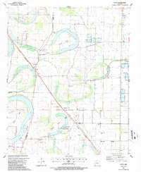
 1987 Keo1987 Print · USGSThe Lonoke and Pulaski county lines meet in this agricultural corridor during the late eighties, where rail and water dictate the landscape. Researchers can trace rural life through landmarks like Alexander Cem, the St Louis Southwestern tracks in Keo, and Millers Chapel.
 - 1987 Map of Scott
 1987 Scott1987 Print · USGSThe Arkansas River bottomlands in the late eighties reveal a landscape of oxbow lakes, ancient earthworks, and rural rail stops. Genealogists and historians can locate family landmarks like Walkers Corner, Le Grande Cem, and the notable Toltec Mounds State Park.
 - 1990 Map of Brinkley, 1991 Print
 1990 Brinkley1991 Print · USGSEastern Arkansas at the start of the 1990s is defined by the agricultural rhythms of the Grand Prairie and the vital White River corridor. Genealogists and historians can trace the rail-linked growth of Brinkley and Des Arc alongside older landmarks like Peckerwood Lake.
Showing maps 1-25 of 40
Top cities near Keo
- Little Rock historical maps
- North Little Rock historical maps
- Jacksonville historical maps
- Sherwood historical maps
- Lonoke historical maps
- England historical maps
See more
Top neighborhoods of Keo
Frequently asked questions
- What are the different types of historical maps available for Keo?
- What is the oldest map of Keo?
- Where can I purchase historical maps of Keo for my home or office?
- Where can I download high-res historical maps of Keo?
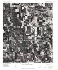
- Are there historical topographic maps available for Keo?
- Is there historical aerial imagery available for Keo?
- Where are historical maps of Keo sourced from?