1970s Maps of Montgomery County, Arkansas
Explore 4 historic maps of Montgomery County from the 1970s. These maps offer a rare glimpse into what life looked like during the 1970s — showing old roads, neighborhoods, homes, and landmarks that have changed or disappeared over time.
Whether you're researching your family's past, planning a metal detecting trip, or studying how Montgomery County's landscape evolved across the 1970s, these high-resolution maps are a powerful tool for exploring the history of this region.
- Focus on a specific era: All maps on this page are from the 1970s, giving you a focused view of this time period.
- See what’s changed: Compare century-old streets, trails, and buildings to today's modern landscape using overlays and satellite layers.
- Research with precision: Use these maps for genealogy, historical research, land use analysis, or educational projects.
- View, download, or print: Maps are fully viewable online in high resolution, and can be downloaded or printed for your own records.
Start exploring Montgomery County's history through authentic maps from the 1970s. This is your window into the past.
Montgomery County, AR maps
(4)- 1979 Map of Lodi, 1980 Print
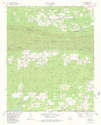 1979 Lodi1980 Print · USGSThe Ouachita foothills of Pike and Montgomery County are shown here in the late seventies as local life centered around small river-valley settlements and mountain gaps. Genealogists and historians can locate family landmarks such as Hopper Cem, Lodi, and the Free Will Baptist Ch.2 unique versions available
 - 1979 Map of Caddo Gap, 1980 Print
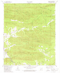 1979 Caddo Gap1980 Print · USGSThe Ouachita foothills near the close of the 1970s reveal a landscape of mountain ridges and river-bottom settlements. Researchers can locate remote family landmarks like Family Cem, trace the Missouri Pacific rail line, and find local gathering spots such as Liberty Ch.
 - 1979 Map of Norman, 1980 Print
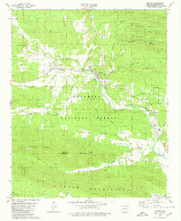 1979 Norman1980 Print · USGSMontgomery County was a landscape of forested ridges and river valleys in the late 1970s. Researchers can trace the path of the Missouri Pacific railroad through Norman or find local landmarks like Caddo Hills Sch and the Chapel Cem.
 - 1979 Map of Glenwood, 1980 Print
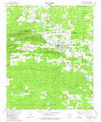 1979 Glenwood1980 Print · USGSThe Caddo River valley and the timberlands of the Ouachita National Forest come to life in this detailed late-seventies survey. Researchers can locate local landmarks like Powers Chapel Cem, the settlement of Rosboro, and several rural Assembly of God churches.
End of results
Showing maps 1-4 of 4
Top cities of Montgomery County
Frequently asked questions
- What are the different types of historical maps available for Montgomery County?
- What is the oldest map of Montgomery County?
- Where can I purchase historical maps of Montgomery County for my home or office?
- Where can I download high-res historical maps of Montgomery County?
- Are there historical topographic maps available for Montgomery County?
- Is there historical aerial imagery available for Montgomery County?
- Where are historical maps of Montgomery County sourced from?