Old Maps of Montgomery County, Arkansas for Genealogy
Trace your family roots with 137 historic maps of Montgomery County. These high-res maps reveal old neighborhoods, homesites, landmarks, and streets — helping you uncover where your ancestors lived and how the area evolved over time.
- Explore historic neighborhoods: Identify where your relatives may have lived in the 1800s or 1900s.
- Compare maps over time: Trace the changes in streets, buildings, and landmarks for multi-generational research.
- Perfect for genealogy & ancestry research: Used by family historians and researchers to map out lineage and migration.
These maps are an incredible resource for exploring your personal connection to Montgomery County's past.
Montgomery County, AR maps
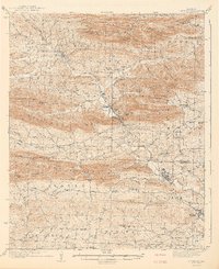
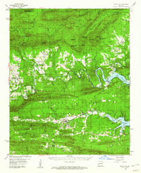
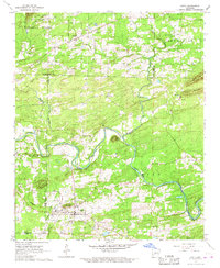
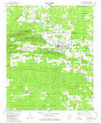
(137)- 1890 Map of Mount Ida
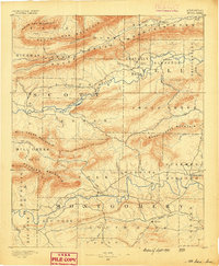 1890 Mount Ida1890 Print · USGSMontgomery and Scott counties are shown in the late nineteenth century, dominated by the ridges of the Ouachita Mountains and the winding Washita or Ouachita River. Genealogists and historians can trace early settlements like Mt. Ida, Oden, and the mining camp at Silver City.7 unique versions available
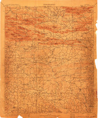
 - 1890 Map of Hot Springs
 1890 Hot Springs1890 Print · USGSThe Ouachita and Fourche La Fave river valleys are mapped here in the late nineteenth century, showing a landscape of isolated mountain settlements. Researchers can trace early family sites near Buckville, Cedar Glades, and the nascent streets of Hot Springs.
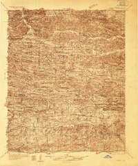
 - 1894 Map of Hot Springs
 1894 Hot Springs1894 Print · USGSThe thermal waters of Hot Springs and the surrounding Ouachita wilderness appear here in the decade before the region’s twentieth-century expansion. Genealogists can trace early homesteading locations and vanished rural hubs like Buckville, Cedar Glades, and Wards Crossing.5 unique versions available
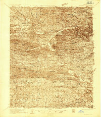
 - 1906 Map of Caddo Gap
 1906 Caddo Gap1906 Print · USGSWest-central Arkansas at the dawn of the twentieth century shows a rugged landscape defined by the Ouachita ridges and early mountain industries. Researchers can trace defunct mining communities like Slatington and Fancy Hill, or locate long-gone railway stops at Hickory Station and Brocktown.3 unique versions available
 - 1936 Map of Athens
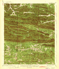
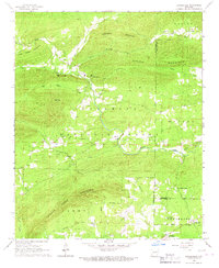
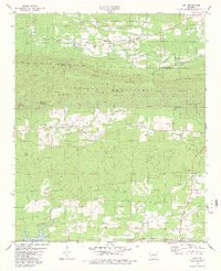
 1936 Athens1936 Print · USGSThe rural communities of western Arkansas were still deeply connected by river valleys and mountain gaps in the mid-1930s. Genealogists can trace family footprints at Athens, Langley, and Misels Chapel, or locate remote burials at Hutchinsons Cem and Abernathy Cem.4 unique versions available
 - 1936 Map of Glenwood
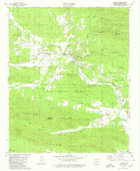
 1936 Glenwood1936 Print · USGSThe Montgomery and Pike county borders meet in this mid-1930s survey of the Arkansas timber and mountain country. Researchers can trace the Missouri Pacific rail line through Glenwood and locate family landmarks like Shockey Chapel and Jones Mill.
 - 1942 Map of Glenwood
 1942 Glenwood1942 Print · USGSThe Ouachita foothills in the mid-1930s are captured here as timber and rail lines defined the valleys around Glenwood. Researchers can trace old family sites and rural infrastructure like the Womble Ranger Sta, Caddo Hill Sch, and Oak Grove Ch.4 unique versions available
 - 1942 Map of Athens
 1942 Athens1942 Print · USGSThe Ouachita highlands of western Arkansas are captured here in the early 1940s, showing a rugged network of forest ridges and small farm settlements. Researchers can locate family sites and local landmarks including Misels Chapel, Cox Cem, and schoolhouses like Miller Sch or Pleasant Hill Sch.
 - 1949 Map of Glenwood, 1983 Print
 1949 Glenwood1983 Print · USGSThe Ouachita highlands of southwest Arkansas are shown here during the late 1930s, as timber railroads and mountain communities defined the region. Researchers can trace family roots at Shockey Chapel, Caddo Hill Sch, or along the Missouri Pacific rail line.
 - 1955 Map of Little Rock, 1978 Print
 1955 Little Rock1978 Print · USGSCentral Arkansas in the mid-fifties exhibits a landscape of growing cities, massive military installations, and mountain reservoirs. Genealogists and historians can trace the industrial Bauxite Mines, regional rail lines, and local landmarks like Antioch Church.
 - 1956 Map of Little Rock
 1956 Little Rock1956 Print · USGSCentral Arkansas in the mid-fifties shows a landscape defined by burgeoning military bases and the timber-and-mineral wealth of the Ouachitas. Genealogists and researchers can trace old rail lines like the Missouri Pacific and find established communities such as Bauxite, Sheridan, and Mabelvale.
 - 1959 Map of Oden, 1960 Print
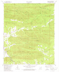
 1959 Oden1960 Print · USGSThe Ouachita River valley in the late fifties is a landscape of mountain ridges and riverside settlements. Researchers can trace family history through local landmarks like Pine Ridge, the Goodner Cem, and the Gaston Lookout Tower.2 unique versions available
 - 1959 Map of Mount Ida, 1960 Print
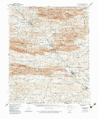
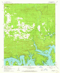
 1959 Mount Ida1960 Print · USGSThe Montgomery County interior is documented in the late fifties as the rising waters of Lake Ouachita began to reshape the river valley. Researchers can trace rural cemeteries and church sites like Crystal Hill Ch, McKinney Cem, and the village of Hog Jaw.2 unique versions available
 - 1960 Map of Little Rock
 1960 Little Rock1960 Print · USGSCentral Arkansas in the late fifties shows a landscape of growing military bases and massive new reservoirs. Local historians can trace the mid-century expansion of Little Rock and Hot Springs alongside the industrial works at Bauxite and the Pine Bluff Arsenal.
 - 1962 Map of Fannie, 1963 Print
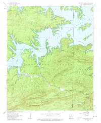
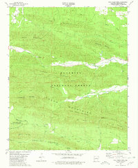
 1962 Fannie1963 Print · USGSThe northern shores of Lake Ouachita and the surrounding national forest are captured here in the early sixties. Researchers can locate family landmarks such as Breashears Cem, Mt Zion Ch, and the small settlement of Fannie.3 unique versions available
 - 1962 Map of Mc Graw Mountain, 1963 Print
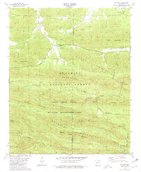
 1962 Mc Graw Mountain1963 Print · USGSThe northern reaches of Montgomery County are defined here by the winding shoreline of Lake Ouachita in the early sixties. Genealogists and local historians can locate Murphy Cem, the Hickorynut Lookout Tower, and early sites like Camp Clearfork.3 unique versions available
 - 1964 Map of Little Rock
 1964 Little Rock1964 Print · USGSCentral Arkansas in the mid-sixties is a landscape of mountain ridges, industrial rail lines, and growing military hubs. Researchers can trace the development of Bauxite and Hot Springs or locate rural landmarks like Sparkman and the Pine Bluff Arsenal.
 - 1966 Map of Bonnerdale, 1967 Print
 1966 Bonnerdale1967 Print · USGSThe Ouachita foothills in the 1960s reveal a landscape of family-named cemeteries and decommissioned timber routes. Genealogists and historians can trace the Old Railroad Grade and locate historic community centers like Alamo, Old Bonnerdale, and Grants Chapel.
 - 1966 Map of Amity, 1967 Print
 1966 Amity1967 Print · USGSAmity and the Caddo River valley are documented here in the mid-1960s, a period of transition for the rural landscapes of Clark and Montgomery counties. Family historians can trace the locations of Old Mt Tabor Ch, the Dillard Cem, and the path of the Missouri Pacific railroad.
 - 1979 Map of Lodi, 1980 Print
 1979 Lodi1980 Print · USGSThe Ouachita foothills of Pike and Montgomery County are shown here in the late seventies as local life centered around small river-valley settlements and mountain gaps. Genealogists and historians can locate family landmarks such as Hopper Cem, Lodi, and the Free Will Baptist Ch.2 unique versions available
 - 1979 Map of Caddo Gap, 1980 Print
 1979 Caddo Gap1980 Print · USGSThe Ouachita foothills near the close of the 1970s reveal a landscape of mountain ridges and river-bottom settlements. Researchers can locate remote family landmarks like Family Cem, trace the Missouri Pacific rail line, and find local gathering spots such as Liberty Ch.
 - 1979 Map of Norman, 1980 Print
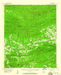
 1979 Norman1980 Print · USGSMontgomery County was a landscape of forested ridges and river valleys in the late 1970s. Researchers can trace the path of the Missouri Pacific railroad through Norman or find local landmarks like Caddo Hills Sch and the Chapel Cem.
 - 1979 Map of Glenwood, 1980 Print
 1979 Glenwood1980 Print · USGSThe Caddo River valley and the timberlands of the Ouachita National Forest come to life in this detailed late-seventies survey. Researchers can locate local landmarks like Powers Chapel Cem, the settlement of Rosboro, and several rural Assembly of God churches.
 - 1980 Map of Polk Creek Mtn, 1981 Print
 1980 Polk Creek Mtn1981 Print · USGSThe interior of Montgomery County comes to life in the early 1980s as a landscape of remote ridges and small mountain communities. Trace family roots at Murphy Ch, find the historic river crossing at Caddo Ford, or locate the isolated settlement of Alf.
 - 1980 Map of Big Fork, 1981 Print
 1980 Big Fork1981 Print · USGSBig Fork and the surrounding Ouachita Mountains are captured here in the late seventies, a period of established forest management and rural preservation. Genealogists and hikers can trace landmarks like Pleasant Grove Cem, Huddleston Cem, and the trails near Little Missouri Falls Recreation Area.
Showing maps 1-25 of 137
Top cities of Montgomery County
Frequently asked questions
- What are the different types of historical maps available for Montgomery County?
- What is the oldest map of Montgomery County?
- Where can I purchase historical maps of Montgomery County for my home or office?
- Where can I download high-res historical maps of Montgomery County?
- Are there historical topographic maps available for Montgomery County?
- Is there historical aerial imagery available for Montgomery County?
- Where are historical maps of Montgomery County sourced from?