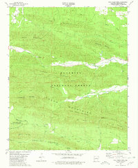
1980 Map of Polk Creek Mtn
USGS Topo · Published 1981About this map
Ouachita National Forest blankets this interior Arkansas landscape, where the ridges of Caddo Mountain and Polk Creek Mountain dictate the flow of the Caddo River and its numerous tributaries. Settled pockets are defined by rural institutions like Murphy Ch and Mt Gilead Ch, while the small community of Alf and the Cox Cem provide tangible links for genealogical research. The map illustrates a landscape of high ridges and deep valleys, including Back Valley and Faith Valley Ch, where transport was historically reliant on crossings like the Caddo Ford. This 1980 record also includes the Caney Creek State Wildlife Management Area, reflecting the region's managed wilderness character during the late twentieth century.
Find a feature on this map
42 named features on this map. Tap any name to fly to it.
Don’t see what you’re looking for? This feature index may not catch every label — zoom into the map to look around manually.
Map Details
Editions of this 1980 Polk Creek Mtn Map
This is the sole edition of this map. No revisions or reprints were ever made.
Other maps of this area

1890 · Mount Ida
USGS Topo · 1:125,000

1906 · Caddo Gap
USGS Topo · 1:125,000

1936 · Athens
USGS Topo · 1:48,000

1936 · Glenwood
USGS Topo · 1:48,000

1942 · Glenwood
USGS Topo · 1:62,500

1942 · Athens
USGS Topo · 1:62,500

1949 · Glenwood
USGS Topo · 1:62,500

1955 · Little Rock
USGS Topo · 1:250,000

1956 · Little Rock
USGS Topo · 1:250,000

1959 · Oden
USGS Topo · 1:62,500