1970s Maps of Perry County, Arkansas
Explore 3 historic maps of Perry County from the 1970s. These maps offer a rare glimpse into what life looked like during the 1970s — showing old roads, neighborhoods, homes, and landmarks that have changed or disappeared over time.
Whether you're researching your family's past, planning a metal detecting trip, or studying how Perry County's landscape evolved across the 1970s, these high-resolution maps are a powerful tool for exploring the history of this region.
- Focus on a specific era: All maps on this page are from the 1970s, giving you a focused view of this time period.
- See what’s changed: Compare century-old streets, trails, and buildings to today's modern landscape using overlays and satellite layers.
- Research with precision: Use these maps for genealogy, historical research, land use analysis, or educational projects.
- View, download, or print: Maps are fully viewable online in high resolution, and can be downloaded or printed for your own records.
Start exploring Perry County's history through authentic maps from the 1970s. This is your window into the past.
Perry County, AR maps
(3)- 1972 Map of Ola, 1974 Print
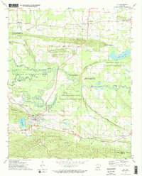 1972 Ola1974 Print · USGSThe Yell County river bottoms and rail lines come into focus in the early 1970s, showing the town of Ola at a geographical crossroads. Researchers can trace family history at Oakland Cemetery or locate the former path of the Old RR Grade and the Mt Tabor Church.2 unique versions available
 - 1972 Map of Casa, 1974 Print
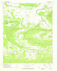 1972 Casa1974 Print · USGSThe river valley and mountain ridges of central Arkansas are captured here in the early seventies, centered on the railroad town of Casa. Genealogists and historians can trace family locations through Needmore Cem, South View Ch, and the rural crossing at Pontoon.2 unique versions available
 - 1977 Map of Russellville
 1977 Russellville1977 Print · USGSThe Arkansas River Valley and surrounding Ozark Mountains are documented here during a period of significant postwar growth and infrastructure development. Genealogists and researchers can locate family landmarks such as Mount Carmel Cem, St Josephs Church, and several remote Coal Mine sites along the Missouri Pacific RR line.
End of results
Showing maps 1-3 of 3
Top cities of Perry County
- Perryville historical maps
- Bigelow historical maps
- Perry historical maps
- Adona historical maps
- Houston historical maps
- Casa historical maps
See more
Frequently asked questions
- What are the different types of historical maps available for Perry County?
- What is the oldest map of Perry County?
- Where can I purchase historical maps of Perry County for my home or office?
- Where can I download high-res historical maps of Perry County?
- Are there historical topographic maps available for Perry County?
- Is there historical aerial imagery available for Perry County?
- Where are historical maps of Perry County sourced from?