1980s Maps of Phillips County, Arkansas
Explore 15 historic maps of Phillips County from the 1980s. These maps offer a rare glimpse into what life looked like during the 1980s — showing old roads, neighborhoods, homes, and landmarks that have changed or disappeared over time.
Whether you're researching your family's past, planning a metal detecting trip, or studying how Phillips County's landscape evolved across the 1980s, these high-resolution maps are a powerful tool for exploring the history of this region.
- Focus on a specific era: All maps on this page are from the 1980s, giving you a focused view of this time period.
- See what’s changed: Compare century-old streets, trails, and buildings to today's modern landscape using overlays and satellite layers.
- Research with precision: Use these maps for genealogy, historical research, land use analysis, or educational projects.
- View, download, or print: Maps are fully viewable online in high resolution, and can be downloaded or printed for your own records.
Start exploring Phillips County's history through authentic maps from the 1980s. This is your window into the past.
Phillips County, AR maps
(15)- 1982 Map of Lakeview
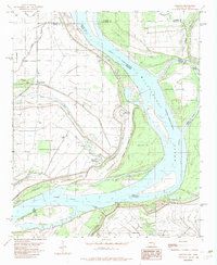
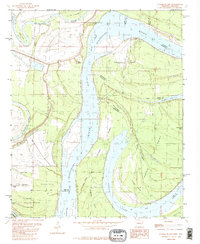
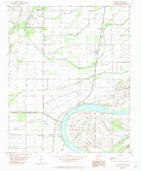 1982 Lakeview1982 Print · USGSThe Phillips County Delta in the early eighties shows a landscape of river-oxbows and drainage canals. Genealogists and local historians can locate rural landmarks such as Old Jerusalem Ch, the Oneida Jr High Sch, and the riverside settlement of Old Town.
 - 1982 Map of Rena Lara
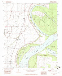
 1982 Rena Lara1982 Print · USGSThe Mississippi River delta at the turn of the 1980s reveals a landscape of massive oxbows and levee-protected settlements. Genealogists and local historians can trace the positions of old river access points like Desoto Landing and rural landmarks such as Morning Star Ch.
 - 1982 Map of La Grange
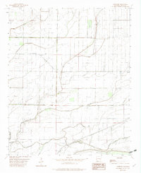
 1982 La Grange1982 Print · USGSThe eastern edge of the Arkansas Delta is defined by Crowley Ridge in the early 1980s, showcasing a landscape of dense forest and river bottomlands. Researchers can trace rural lineages through sites like La Grange Cem, Pettys Chapel, and the small community of Jeffersonville.
 - 1982 Map of Helena
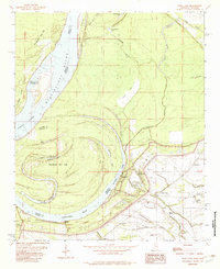
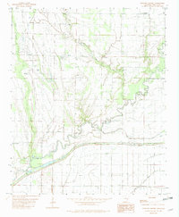
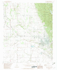
 1982 Helena1982 Print · USGSAs the 1980s began, the Mississippi River Delta at Helena maintained its vital connection between the river's flow and the heights of Crowleys Ridge. Genealogists and historians can trace family locations through several burial grounds like Maple Hill Cem and settlements such as Prairie Point or Helena Crossing.
 - 1982 Map of Laconia
 1982 Laconia1982 Print · USGSThe Arkansas-Mississippi borderlands along the great river are captured here in the early eighties. Researchers can trace family sites at Mt Pleasant Ch and Luke Cem, or locate riverside landmarks like Cessions Landing and Island No 69.
 - 1982 Map of Mellwood
 1982 Mellwood1982 Print · USGSThe Arkansas Delta and the Mississippi River border come alive in the early eighties, showing a landscape of river landings and rail spurs. Genealogists can trace family connections to Mellwood, Lundell, or Ferguson, or locate old river access points at Dawson Landing and Ludlow Landing.
 - 1982 Map of Lambrook
 1982 Lambrook1982 Print · USGSPhillips County in the early eighties shows a Delta landscape transformed by heavy drainage projects and rural agriculture. Genealogists can locate family landmarks such as Brooks Chapel, Lambrook Ch, and the small settlements of Gauzey and Ratio.
 - 1982 Map of Watkins Corner
 1982 Watkins Corner1982 Print · USGSPhillips County in the early eighties was a landscape of small Delta settlements and winding waterways. Researchers can locate the exact positions of Cypert, Kingtown, and Connells Point, alongside family landmarks like Taylor Cem and Mt Zion Ch.
 - 1982 Map of Stubbs Island
 1982 Stubbs Island1982 Print · USGSThe Mississippi River Delta at the start of the 1980s reveals a complex world of shifting watercourses and state boundaries. Trace the remnants of the old river channel through Hardin Cut-off, the waters of Laddie Lake, and the isolated reaches of Stubbs Island.2 unique versions available
 - 1982 Map of Elaine
 1982 Elaine1982 Print · USGSElaine and the Arkansas delta are captured in the early eighties as the river's winding oxbows and rural settlements define the landscape. Researchers can trace family roots through Morning Star Cem or locate historic river access points like Burke Landing and Modoc.
 - 1982 Map of West Helena
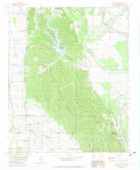
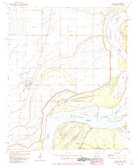
 1982 West Helena1982 Print · USGSPhillips County is captured here in the early eighties as the industrial and transit hub of West Helena meets the timbered slopes of the St Francis National Forest. Researchers can locate several rural landmarks including Billingsley Cem, Jackson Chapel Center, and the railroad works at Helena Junction.
 - 1984 Map of Helena, 1985 Print
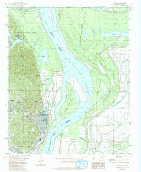
 1984 Helena1985 Print · USGSThe Delta landscape of Arkansas and Mississippi comes to life in this mid-eighties survey of river bends and ridge settlements. Researchers can trace the rail-and-river economy through Missouri Pacific lines and local landmarks like Whiskey Island or Marianna.
 - 1984 Map of Clarksdale, 1985 Print
 1984 Clarksdale1985 Print · USGSThe Mississippi Delta in the 1980s shows a landscape defined by its great river meanders and a dense network of bayous and rail lines. Researchers can trace the path of the Illinois Central Gulf through Clarksdale or locate river landmarks like Moon Lake and Friars Point.
 - 1986 Map of De Witt
 1986 De Witt1986 Print · USGSThe Arkansas Delta in the mid-1980s was a landscape defined by massive river locks, state prison farms, and the rail-side grain towns of Arkansas County. Researchers can trace the path of the St Louis Southwestern Railway through settlements like De Witt, Altheimer, and Humphrey.2 unique versions available
 - 1986 Map of Brinkley
 1986 Brinkley1986 Print · USGSThe Grand Prairie and White River basin come to life in the mid-1980s, showing the intersection of heavy rail and interstate travel through eastern Arkansas. Genealogists can locate family sites near Sylvania Cem, Oak Grove Ch, and the rural community of De Valls Bluff.
End of results
Showing maps 1-15 of 15
Top cities of Phillips County
- Helena-West Helena historical maps
- Marvell historical maps
- Elaine historical maps
- Lake View historical maps
- Lexa historical maps
Frequently asked questions
- What are the different types of historical maps available for Phillips County?
- What is the oldest map of Phillips County?
- Where can I purchase historical maps of Phillips County for my home or office?
- Where can I download high-res historical maps of Phillips County?
- Are there historical topographic maps available for Phillips County?
- Is there historical aerial imagery available for Phillips County?
- Where are historical maps of Phillips County sourced from?