1940s Maps of Pike County, Arkansas
Explore 4 historic maps of Pike County from the 1940s. These maps offer a rare glimpse into what life looked like during the 1940s — showing old roads, neighborhoods, homes, and landmarks that have changed or disappeared over time.
Whether you're researching your family's past, planning a metal detecting trip, or studying how Pike County's landscape evolved across the 1940s, these high-resolution maps are a powerful tool for exploring the history of this region.
- Focus on a specific era: All maps on this page are from the 1940s, giving you a focused view of this time period.
- See what’s changed: Compare century-old streets, trails, and buildings to today's modern landscape using overlays and satellite layers.
- Research with precision: Use these maps for genealogy, historical research, land use analysis, or educational projects.
- View, download, or print: Maps are fully viewable online in high resolution, and can be downloaded or printed for your own records.
Start exploring Pike County's history through authentic maps from the 1940s. This is your window into the past.
Pike County, AR maps
(4)- 1942 Map of Glenwood
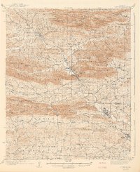 1942 Glenwood1942 Print · USGSThe Ouachita foothills in the mid-1930s are captured here as timber and rail lines defined the valleys around Glenwood. Researchers can trace old family sites and rural infrastructure like the Womble Ranger Sta, Caddo Hill Sch, and Oak Grove Ch.4 unique versions available
 - 1942 Map of Athens
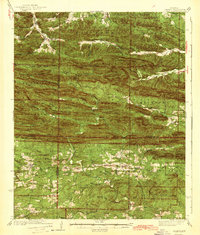 1942 Athens1942 Print · USGSThe Ouachita highlands of western Arkansas are captured here in the early 1940s, showing a rugged network of forest ridges and small farm settlements. Researchers can locate family sites and local landmarks including Misels Chapel, Cox Cem, and schoolhouses like Miller Sch or Pleasant Hill Sch.
 - 1943 Map of Antoine
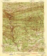 1943 Antoine1943 Print · USGSPike and Clark counties come into focus during the early 1940s, highlighting a landscape of river-bottom settlements and upland timber tracts. Researchers can trace family roots at Meeks Settlement or locate remote rural landmarks like Rosewall Sch and Nutts.3 unique versions available
 - 1949 Map of Glenwood, 1983 Print
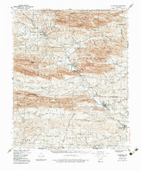 1949 Glenwood1983 Print · USGSThe Ouachita highlands of southwest Arkansas are shown here during the late 1930s, as timber railroads and mountain communities defined the region. Researchers can trace family roots at Shockey Chapel, Caddo Hill Sch, or along the Missouri Pacific rail line.
End of results
Showing maps 1-4 of 4
Top cities of Pike County
Frequently asked questions
- What are the different types of historical maps available for Pike County?
- What is the oldest map of Pike County?
- Where can I purchase historical maps of Pike County for my home or office?
- Where can I download high-res historical maps of Pike County?
- Are there historical topographic maps available for Pike County?
- Is there historical aerial imagery available for Pike County?
- Where are historical maps of Pike County sourced from?