Old Maps of Pike County, Arkansas for Genealogy
Trace your family roots with 131 historic maps of Pike County. These high-res maps reveal old neighborhoods, homesites, landmarks, and streets — helping you uncover where your ancestors lived and how the area evolved over time.
- Explore historic neighborhoods: Identify where your relatives may have lived in the 1800s or 1900s.
- Compare maps over time: Trace the changes in streets, buildings, and landmarks for multi-generational research.
- Perfect for genealogy & ancestry research: Used by family historians and researchers to map out lineage and migration.
These maps are an incredible resource for exploring your personal connection to Pike County's past.
Pike County, AR maps
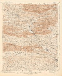
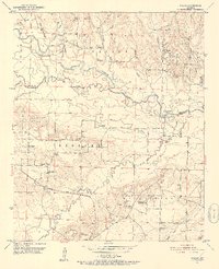
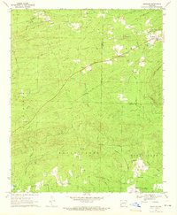
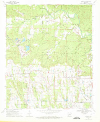
(131)- 1901 Map of Gurdon
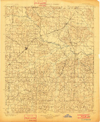 1901 Gurdon1901 Print · USGSSouthwest Arkansas at the dawn of the twentieth century was a landscape defined by the arrival of the rails and the timber industry. Researchers can trace the development of early rail towns like Gurdon, Prescott, and Whelen Springs along the St. Louis Iron Mountain and Southern R. R.3 unique versions available
 - 1906 Map of Caddo Gap
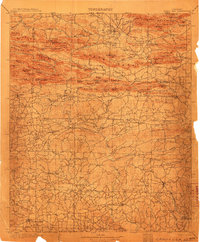 1906 Caddo Gap1906 Print · USGSWest-central Arkansas at the dawn of the twentieth century shows a rugged landscape defined by the Ouachita ridges and early mountain industries. Researchers can trace defunct mining communities like Slatington and Fancy Hill, or locate long-gone railway stops at Hickory Station and Brocktown.3 unique versions available
 - 1936 Map of Athens
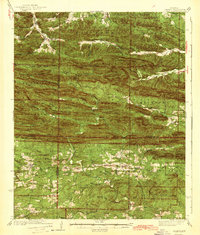
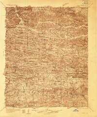 1936 Athens1936 Print · USGSThe rural communities of western Arkansas were still deeply connected by river valleys and mountain gaps in the mid-1930s. Genealogists can trace family footprints at Athens, Langley, and Misels Chapel, or locate remote burials at Hutchinsons Cem and Abernathy Cem.4 unique versions available
 - 1936 Map of Glenwood
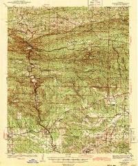
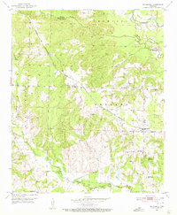
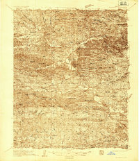 1936 Glenwood1936 Print · USGSThe Montgomery and Pike county borders meet in this mid-1930s survey of the Arkansas timber and mountain country. Researchers can trace the Missouri Pacific rail line through Glenwood and locate family landmarks like Shockey Chapel and Jones Mill.
 - 1942 Map of Glenwood
 1942 Glenwood1942 Print · USGSThe Ouachita foothills in the mid-1930s are captured here as timber and rail lines defined the valleys around Glenwood. Researchers can trace old family sites and rural infrastructure like the Womble Ranger Sta, Caddo Hill Sch, and Oak Grove Ch.4 unique versions available
 - 1942 Map of Athens
 1942 Athens1942 Print · USGSThe Ouachita highlands of western Arkansas are captured here in the early 1940s, showing a rugged network of forest ridges and small farm settlements. Researchers can locate family sites and local landmarks including Misels Chapel, Cox Cem, and schoolhouses like Miller Sch or Pleasant Hill Sch.
 - 1943 Map of Antoine
 1943 Antoine1943 Print · USGSPike and Clark counties come into focus during the early 1940s, highlighting a landscape of river-bottom settlements and upland timber tracts. Researchers can trace family roots at Meeks Settlement or locate remote rural landmarks like Rosewall Sch and Nutts.3 unique versions available
 - 1949 Map of Glenwood, 1983 Print
 1949 Glenwood1983 Print · USGSThe Ouachita highlands of southwest Arkansas are shown here during the late 1930s, as timber railroads and mountain communities defined the region. Researchers can trace family roots at Shockey Chapel, Caddo Hill Sch, or along the Missouri Pacific rail line.
 - 1951 Map of Pisgah, 1952 Print
 1951 Pisgah1952 Print · USGSSouthwest Arkansas in the early fifties shows a landscape of riverbottom farms and rural townships. Trace family history through Billstown Cem, locate old junctions like Billstown, and follow the Prescott and Northwestern rail line.3 unique versions available
 - 1951 Map of McCaskill, 1952 Print
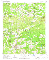
 1951 McCaskill1952 Print · USGSMcCaskill and the surrounding timberlands of Hempstead County are shown here in the early fifties, anchored by the PRESCOTT AND NORTHWESTERN rail line. Genealogists can locate family landmarks such as Young Cem, the Blevins Sch No 2, and local churches like Avery Chapel.3 unique versions available
 - 1953 Map of El Dorado, 1967 Print
 1953 El Dorado1967 Print · USGSSouth Arkansas in the mid-1960s was a landscape of industrial growth and river-fed commerce. Researchers can trace the extensive Oil and Gas Fields around Magnolia, the expansive U S Naval Ammunition Depot, and the busy rail lines of the Missouri Pacific.3 unique versions available
 - 1955 Map of Little Rock, 1978 Print
 1955 Little Rock1978 Print · USGSCentral Arkansas in the mid-fifties exhibits a landscape of growing cities, massive military installations, and mountain reservoirs. Genealogists and historians can trace the industrial Bauxite Mines, regional rail lines, and local landmarks like Antioch Church.
 - 1956 Map of Little Rock
 1956 Little Rock1956 Print · USGSCentral Arkansas in the mid-fifties shows a landscape defined by burgeoning military bases and the timber-and-mineral wealth of the Ouachitas. Genealogists and researchers can trace old rail lines like the Missouri Pacific and find established communities such as Bauxite, Sheridan, and Mabelvale.
 - 1957 Map of El Dorado
 1957 El Dorado1957 Print · USGSSouth Arkansas in the mid-1950s was a critical hub of military logistics and rail-river commerce. Genealogists and historians can trace family land across the Arkansas Louisiana border and locate sites like the U.S. Naval Ammunition Depot or the rail junctions at Magnolia and Camden.
 - 1958 Map of El Dorado
 1958 El Dorado1958 Print · USGSSouthern Arkansas and the Louisiana borderlands are shown during a period of heavy rail traffic and defense industry activity. Researchers can trace the legacy of the U. S. Naval Ammunition Depot or locate family roots in Smackover, Huttig, and Nashville.3 unique versions available
 - 1960 Map of El Dorado
 1960 El Dorado1960 Print · USGSSouth Central Arkansas in the late fifties was a hub of energy production and defense industry. Researchers can trace the extensive Oil and Gas Fields around El Dorado or locate family landmarks like Old Park Cem and New Hope Church.
 - 1960 Map of Little Rock
 1960 Little Rock1960 Print · USGSCentral Arkansas in the late fifties shows a landscape of growing military bases and massive new reservoirs. Local historians can trace the mid-century expansion of Little Rock and Hot Springs alongside the industrial works at Bauxite and the Pine Bluff Arsenal.
 - 1964 Map of Little Rock
 1964 Little Rock1964 Print · USGSCentral Arkansas in the mid-sixties is a landscape of mountain ridges, industrial rail lines, and growing military hubs. Researchers can trace the development of Bauxite and Hot Springs or locate rural landmarks like Sparkman and the Pine Bluff Arsenal.
 - 1966 Map of Amity, 1967 Print
 1966 Amity1967 Print · USGSAmity and the Caddo River valley are documented here in the mid-1960s, a period of transition for the rural landscapes of Clark and Montgomery counties. Family historians can trace the locations of Old Mt Tabor Ch, the Dillard Cem, and the path of the Missouri Pacific railroad.
 - 1969 Map of Narrows Dam, 1972 Print
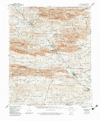
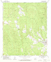
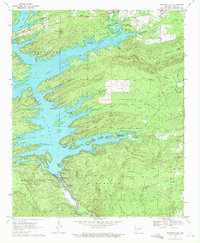 1969 Narrows Dam1972 Print · USGSPike County's landscape was defined by the waters of the Little Missouri River and the surrounding ridges in the late sixties. Trace the development of Lake Greeson alongside older landmarks like Midway Cem, the settlement of Kirby, and the engineering of Narrows Dam.2 unique versions available
 - 1969 Map of Newhope, 1972 Print
 1969 Newhope1972 Print · USGSThe rural border of Pike and Howard Counties comes into focus just as the waters of Dierks Lake were beginning to rise in the late sixties. Trace family roots and vanished landmarks at Antioch Cem, the Old Railroad Grade, and the settlement of Newhope.2 unique versions available
 - 1970 Map of Delight, 1971 Print
 1970 Delight1971 Print · USGSThe community of Delight and its surrounding timberlands are documented here just as the late twentieth century began. Genealogists and local historians can trace family roots through landmarks like Brocktown Cem, Saline Ch, and the rural settlement at Steltown.2 unique versions available
 - 1970 Map of Murfreesboro, 1972 Print
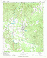 1970 Murfreesboro1972 Print · USGSThe Pike County seat and its world-famous diamond field are captured here during the early 1970s. Trace the local genealogy and land use of the river valley through sites like the Crater of Diamonds, Indian Mounds, and Maple Springs Ch.2 unique versions available
 - 1970 Map of Murfreesboro NE, 1972 Print
 1970 Murfreesboro NE1972 Print · USGSNortheastern Pike County appears as a network of ridges and river valleys in the early 1970s. Genealogists and local historians can trace legacy sites like Macedonia Cem and Hannon Cem or locate the old Shale Pit near Woodall Creek.2 unique versions available
 - 1970 Map of Nathan, 1972 Print
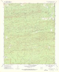
 1970 Nathan1972 Print · USGSSouthwest Arkansas in the early seventies shows a landscape shaped by timber and mining transport. Genealogists and local historians can trace family locations near Corinth, Nathan, and numerous burial sites like Biggs Chapel Cem and Polk Cem.2 unique versions available
Showing maps 1-25 of 131
Top cities of Pike County
Frequently asked questions
- What are the different types of historical maps available for Pike County?
- What is the oldest map of Pike County?
- Where can I purchase historical maps of Pike County for my home or office?
- Where can I download high-res historical maps of Pike County?
- Are there historical topographic maps available for Pike County?
- Is there historical aerial imagery available for Pike County?
- Where are historical maps of Pike County sourced from?