1980s Maps of Wrightsville, Arkansas
Explore 3 historic maps of Wrightsville from the 1980s. These maps offer a rare glimpse into what life looked like during the 1980s — showing old roads, neighborhoods, homes, and landmarks that have changed or disappeared over time.
Whether you're researching your family's past, planning a metal detecting trip, or studying how Wrightsville's landscape evolved across the 1980s, these high-resolution maps are a powerful tool for exploring the history of this region.
- Focus on a specific era: All maps on this page are from the 1980s, giving you a focused view of this time period.
- See what’s changed: Compare century-old streets, trails, and buildings to today's modern landscape using overlays and satellite layers.
- Research with precision: Use these maps for genealogy, historical research, land use analysis, or educational projects.
- View, download, or print: Maps are fully viewable online in high resolution, and can be downloaded or printed for your own records.
Start exploring Wrightsville's history through authentic maps from the 1980s. This is your window into the past.
Wrightsville, AR maps
(3)- 1985 Map of Little Rock, 1988 Print
 1985 Little Rock1988 Print · USGSLittle Rock and its surrounding river valley are shown in the mid-eighties as the region balanced urban expansion with its industrial and military roots. Genealogists and historians can locate dozens of institutions and family landmarks, including Mount Holly Cem, the Bauxite Mines, and Central High Sch.
 - 1986 Map of Sweet Home
 1986 Sweet Home1986 Print · USGSThe Arkansas River corridor south of Little Rock is shown in the mid-1980s as a bustling industrial and transport hub. Genealogists can trace families around Sweet Home and College Station, while historians can locate the David D Terry Lock and Dam and Baucum Cem.
 - 1987 Map of Woodson, 1988 Print
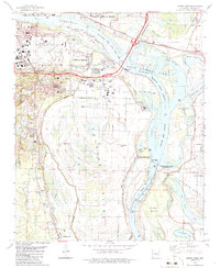
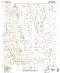 1987 Woodson1988 Print · USGSThe Arkansas River lowlands south of Little Rock come into focus in the mid-1980s, where river bends and bayous meet rural settlements. Researchers can trace the layout of Wrightsville, find family sites at Kuykendall Cem, or locate local landmarks like Gospel Temple Ch.2 unique versions available
End of results
Showing maps 1-3 of 3
Top cities near Wrightsville
- Little Rock historical maps
- North Little Rock historical maps
- Jacksonville historical maps
- Sherwood historical maps
- Maumelle historical maps
- England historical maps
See more
Top neighborhoods of Wrightsville
Frequently asked questions
- What are the different types of historical maps available for Wrightsville?
- What is the oldest map of Wrightsville?
- Where can I purchase historical maps of Wrightsville for my home or office?
- Where can I download high-res historical maps of Wrightsville?
- Are there historical topographic maps available for Wrightsville?
- Is there historical aerial imagery available for Wrightsville?
- Where are historical maps of Wrightsville sourced from?