1940s Maps of Wrightsville, Arkansas
Explore 2 historic maps of Wrightsville from the 1940s. These maps offer a rare glimpse into what life looked like during the 1940s — showing old roads, neighborhoods, homes, and landmarks that have changed or disappeared over time.
Whether you're researching your family's past, planning a metal detecting trip, or studying how Wrightsville's landscape evolved across the 1940s, these high-resolution maps are a powerful tool for exploring the history of this region.
- Focus on a specific era: All maps on this page are from the 1940s, giving you a focused view of this time period.
- See what’s changed: Compare century-old streets, trails, and buildings to today's modern landscape using overlays and satellite layers.
- Research with precision: Use these maps for genealogy, historical research, land use analysis, or educational projects.
- View, download, or print: Maps are fully viewable online in high resolution, and can be downloaded or printed for your own records.
Start exploring Wrightsville's history through authentic maps from the 1940s. This is your window into the past.
Wrightsville, AR maps
(2)- 1940 Map of Woodson, 1945 Print
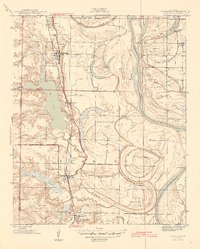 1940 Woodson1945 Print · USGSPulaski County at the start of the 1940s reveals a riverside landscape of bayous and railroad towns. Researchers can trace rural life through landmarks like Gospel Temple Ch, the State Industrial School, and Campbell Cem.2 unique versions available
 - 1945 Map of Sweet Home, 1946 Print
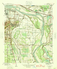 1945 Sweet Home1946 Print · USGSThe southern outskirts of Little Rock and the river bottoms come alive in the mid-forties, showing a landscape of industry and community. Genealogists can trace family roots through College Station, Higgins, and Zion Wheel Ch or locate burials at Cornerstone Cem.3 unique versions available
End of results
Showing maps 1-2 of 2
Top cities near Wrightsville
- Little Rock historical maps
- North Little Rock historical maps
- Jacksonville historical maps
- Sherwood historical maps
- Maumelle historical maps
- England historical maps
See more
Top neighborhoods of Wrightsville
Frequently asked questions
- What are the different types of historical maps available for Wrightsville?
- What is the oldest map of Wrightsville?
- Where can I purchase historical maps of Wrightsville for my home or office?
- Where can I download high-res historical maps of Wrightsville?
- Are there historical topographic maps available for Wrightsville?
- Is there historical aerial imagery available for Wrightsville?
- Where are historical maps of Wrightsville sourced from?