1950s Maps of Wrightsville, Arkansas
Explore 4 historic maps of Wrightsville from the 1950s. These maps offer a rare glimpse into what life looked like during the 1950s — showing old roads, neighborhoods, homes, and landmarks that have changed or disappeared over time.
Whether you're researching your family's past, planning a metal detecting trip, or studying how Wrightsville's landscape evolved across the 1950s, these high-resolution maps are a powerful tool for exploring the history of this region.
- Focus on a specific era: All maps on this page are from the 1950s, giving you a focused view of this time period.
- See what’s changed: Compare century-old streets, trails, and buildings to today's modern landscape using overlays and satellite layers.
- Research with precision: Use these maps for genealogy, historical research, land use analysis, or educational projects.
- View, download, or print: Maps are fully viewable online in high resolution, and can be downloaded or printed for your own records.
Start exploring Wrightsville's history through authentic maps from the 1950s. This is your window into the past.
Wrightsville, AR maps
(4)- 1954 Map of Woodson, 1957 Print
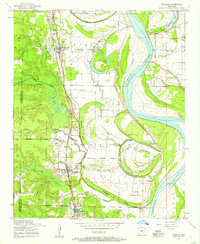 1954 Woodson1957 Print · USGSIn the mid-fifties, the riverfront communities south of Little Rock were shaped by the winding Arkansas River and the busy Missouri Pacific railroad. Genealogists and local historians can locate several family burial grounds and country parishes, such as Kuykendall Cemetery, Virginia Church, and Nelson School.3 unique versions available
 - 1954 Map of Sweet Home, 1957 Print
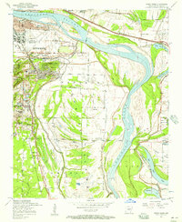 1954 Sweet Home1957 Print · USGSSoutheast of Little Rock in the mid-fifties, this area shows a landscape shaped by the Arkansas River and industrial growth. Researchers can find family-named locations such as College Station, trace the Missouri Pacific rail lines, and locate rural landmarks like Zion Hill Cemetery and Browns Gin.
 - 1955 Map of Little Rock, 1978 Print
 1955 Little Rock1978 Print · USGSCentral Arkansas in the mid-fifties exhibits a landscape of growing cities, massive military installations, and mountain reservoirs. Genealogists and historians can trace the industrial Bauxite Mines, regional rail lines, and local landmarks like Antioch Church.
 - 1956 Map of Little Rock
 1956 Little Rock1956 Print · USGSCentral Arkansas in the mid-fifties shows a landscape defined by burgeoning military bases and the timber-and-mineral wealth of the Ouachitas. Genealogists and researchers can trace old rail lines like the Missouri Pacific and find established communities such as Bauxite, Sheridan, and Mabelvale.
End of results
Showing maps 1-4 of 4
Top cities near Wrightsville
- Little Rock historical maps
- North Little Rock historical maps
- Jacksonville historical maps
- Sherwood historical maps
- Maumelle historical maps
- England historical maps
See more
Top neighborhoods of Wrightsville
Frequently asked questions
- What are the different types of historical maps available for Wrightsville?
- What is the oldest map of Wrightsville?
- Where can I purchase historical maps of Wrightsville for my home or office?
- Where can I download high-res historical maps of Wrightsville?
- Are there historical topographic maps available for Wrightsville?
- Is there historical aerial imagery available for Wrightsville?
- Where are historical maps of Wrightsville sourced from?