1970s Maps of Saline County, Arkansas
Explore 11 historic maps of Saline County from the 1970s. These maps offer a rare glimpse into what life looked like during the 1970s — showing old roads, neighborhoods, homes, and landmarks that have changed or disappeared over time.
Whether you're researching your family's past, planning a metal detecting trip, or studying how Saline County's landscape evolved across the 1970s, these high-resolution maps are a powerful tool for exploring the history of this region.
- Focus on a specific era: All maps on this page are from the 1970s, giving you a focused view of this time period.
- See what’s changed: Compare century-old streets, trails, and buildings to today's modern landscape using overlays and satellite layers.
- Research with precision: Use these maps for genealogy, historical research, land use analysis, or educational projects.
- View, download, or print: Maps are fully viewable online in high resolution, and can be downloaded or printed for your own records.
Start exploring Saline County's history through authentic maps from the 1970s. This is your window into the past.
Saline County, AR maps
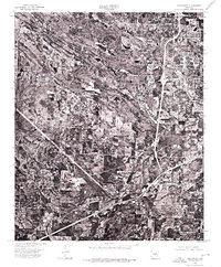
(11)- 1970 Map of Redfield, 1972 Print
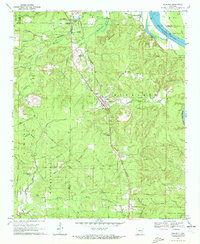 1970 Redfield1972 Print · USGSThe Missouri Pacific railroad and Arkansas River define this Arkansas landscape in the early seventies, spanning from the Saline County line to the edge of the Pine Bluff Arsenal. Researchers can trace old family sites at English Place or find rural landmarks like Garden Springs Ch and Redfield Cem.2 unique versions available
 - 1972 Map of Goosepond Mountain, 1974 Print
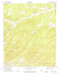
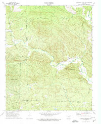 1972 Goosepond Mountain1974 Print · USGSThe borderlands of Saline and Garland Counties are captured in the early 1970s during the early development of Hot Springs Village. Researchers can trace old family sites and local landmarks like Talley Cem, Antioch Ch, and the Lookout Tower on Goosepond Mountain.3 unique versions available
 - 1972 Map of Lonsdale, 1974 Print
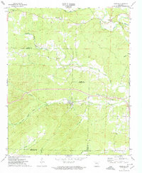 1972 Lonsdale1974 Print · USGSThe Garland and Saline County borderlands in the early seventies reveal a rural landscape defined by the Saline River forks. Researchers can trace family sites at Slate Branch Cem, locate the Rural Dale Sch, or follow the path of the OLD RAILROAD GRADE.4 unique versions available
 - 1972 Map of Lonsdale NE, 1974 Print
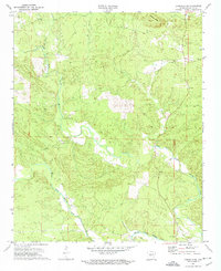 1972 Lonsdale NE1974 Print · USGSSaline County’s river forks and ridgelines are captured here during the early seventies, showing the rural communities of central Arkansas. Researchers can locate family landmarks like Wesleys Chapel Cem, Gravel Hill Ch, and Bolin Cem.4 unique versions available
 - 1972 Map of Fountain Lake, 1974 Print
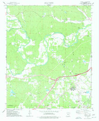
 1972 Fountain Lake1974 Print · USGSGarland County and the surrounding hills were witnessing the early growth of Hot Springs Village and Fountain Lake in the early 1970s. Researchers can trace historic cemeteries and churches such as McClendon Cem, Rockdale Ch, and the Missouri Pacific rail line.3 unique versions available
 - 1974 Map of Benton, 1977 Print
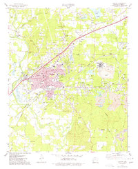 1974 Benton1977 Print · USGSBenton and the surrounding Saline County mining district are captured in the mid-seventies just as the aluminum industry and rail lines shaped the local economy. Researchers can locate family landmarks like Woodland Cem, early schools such as Perrin Sch, and the extensive Mine works near Bauxite.2 unique versions available
 - 1974 Map of Lake Norrell, 1977 Print
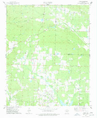
 1974 Lake Norrell1977 Print · USGSSaline County’s timbered ridges and river valleys are captured here during the mid-seventies, centered on the newly managed waters of the reservoir. Researchers can trace rural congregation sites and family burial grounds like Old Union Cem, Grape Chapel, and Langley Cem.3 unique versions available
 - 1974 Map of Haskell, 1977 Print
 1974 Haskell1977 Print · USGSThe Saline River valley in the mid-1970s reveals a transitioning landscape of rural homesteads and emerging infrastructure. Researchers can locate family burial grounds like Grimm Cem, study the MISSOURI PACIFIC rail lines, or trace the grounds of the Benton State Hospital.3 unique versions available
 - 1974 Map of Congo, 1977 Print
 1974 Congo1977 Print · USGSThe Saline and Pulaski county line runs through this mid-1970s landscape of rural settlements and winding creeks. Researchers can trace family roots through numerous local landmarks, including Pipkin Cemetery, Congo Church, and the community of Avilla.3 unique versions available
 - 1975 Map of Alexander, 1976 Print
 1975 Alexander1976 Print · USGSCentral Arkansas saw significant suburban expansion in the mid-seventies as the areas south of the capital grew. Genealogists and local historians can trace the early footprints of Little Rock, Alexander, and the community of Mabelvale.
 - 1975 Map of Little Rock, 1976 Print
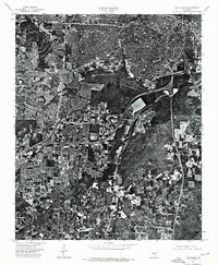 1975 Little Rock1976 Print · USGSLittle Rock and its surrounding landscape are revealed in detailed aerial photography from the mid-seventies. Researchers can trace the exact footprint of urban neighborhoods near the Arkansas R and the density of Little Rock at this moment in time.
End of results
Showing maps 1-11 of 11
Top cities of Saline County
- Benton historical maps
- Bryant historical maps
- Haskell historical maps
- Alexander historical maps
- Shannon Hills historical maps
- Salem historical maps
See more
Frequently asked questions
- What are the different types of historical maps available for Saline County?
- What is the oldest map of Saline County?
- Where can I purchase historical maps of Saline County for my home or office?
- Where can I download high-res historical maps of Saline County?
- Are there historical topographic maps available for Saline County?
- Is there historical aerial imagery available for Saline County?
- Where are historical maps of Saline County sourced from?