1940s Maps of Scott County, Arkansas
Explore 10 historic maps of Scott County from the 1940s. These maps offer a rare glimpse into what life looked like during the 1940s — showing old roads, neighborhoods, homes, and landmarks that have changed or disappeared over time.
Whether you're researching your family's past, planning a metal detecting trip, or studying how Scott County's landscape evolved across the 1940s, these high-resolution maps are a powerful tool for exploring the history of this region.
- Focus on a specific era: All maps on this page are from the 1940s, giving you a focused view of this time period.
- See what’s changed: Compare century-old streets, trails, and buildings to today's modern landscape using overlays and satellite layers.
- Research with precision: Use these maps for genealogy, historical research, land use analysis, or educational projects.
- View, download, or print: Maps are fully viewable online in high resolution, and can be downloaded or printed for your own records.
Start exploring Scott County's history through authentic maps from the 1940s. This is your window into the past.
Scott County, AR maps
(10)- 1940 Map of Waldron
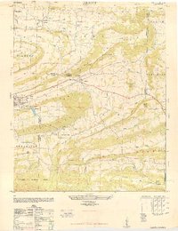
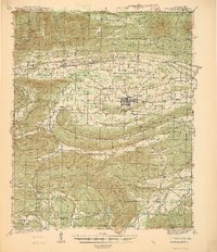 1940 Waldron1940 Print · USGSWaldron and the surrounding Ouachita highlands are shown here in the years leading up to the Second World War. Researchers can trace the heritage of rural Scott County through its many local schools and cemeteries, from Evening Shade Sch to the County Farm and Hon Cem.
 - 1941 Map of Waldron
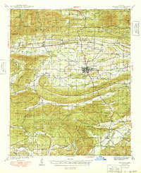
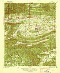 1941 Waldron1941 Print · USGSThe Scott County highlands come alive in the late 1930s, showing the vital rail junction at Waldron. Researchers can locate rural landmarks like Old Salem Ch, Hon Cem, and old mountain schoolhouses like Whisenhunt Sch.
 - 1943 Map of Fort Smith
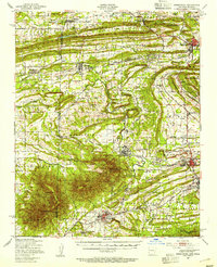
 1943 Fort Smith1943 Print · USGSFort Smith and the Arkansas River valley are shown here during the height of the Second World War as the region became a major military hub. Genealogists and researchers can locate several rural schools and churches, such as St Marys School and Pleasant Ridge Church and Cem, alongside industrial sites like the Strip Mine and Smelter.
 - 1946 Map of Fort Smith
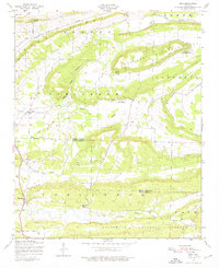
 1946 Fort Smith1946 Print · USGSThe Arkansas-Oklahoma borderlands appear here in the mid-forties, as new reservoirs began to transform the river valleys. Genealogists and historians can trace rail-served towns from Muskogee to Fort Smith and locate landmarks like Camp Chaffee.
 - 1947 Map of Greenwood, 1954 Print
 1947 Greenwood1954 Print · USGSThe Arkansas-Oklahoma border region thrived on coal and rail just after the war. Researchers can trace family ties at Old Jenny Lind and locate industrial landmarks like the Frazier Mine or the Midland Valley railroad.
 - 1947 Map of Barber, 1954 Print
 1947 Barber1954 Print · USGSSebastian County and the surrounding ridges are captured in the late 1940s, showing the intersection of military expansion and rural Arkansas life. Genealogists and historians can trace family locations through Union Ridge Cem, Milltown, and Liberty Ch.
 - 1947 Map of Ione, 1976 Print
 1947 Ione1976 Print · USGSThe Petit Jean River valley at the Logan and Scott county line is shown here just after the war. Researchers can locate family landmarks like Earl Prairie District School No 66, French Prairie Cemetery, and the old gin mill near Lucas.2 unique versions available
 - 1948 Map of Abbott
 1948 Abbott1948 Print · USGSWestern Arkansas at the end of the 1940s reveals a landscape of ridges and rail-side towns along the Rock Island line. Genealogists and local historians can trace family roots through sites like Pine Grove Valley, Crossroads School, and Cantrell Cemetery.4 unique versions available
 - 1948 Map of Huntington, 1966 Print
 1948 Huntington1966 Print · USGSPost-war Arkansas coal country is vividly documented here just as the mining industry shaped local life. Genealogists and historians can trace family-named sites and vanished industrial hubs like Arkola, Gooberhull School, and the Northwestern Coal Company.3 unique versions available
 - 1949 Map of Waldron
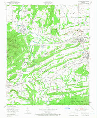
 1949 Waldron1949 Print · USGSWaldron and the surrounding Scott County timberlands are captured here in the late 1940s as the railroad and river economy defined local life. Genealogists can trace family landmarks like Hon Cem, Square Rock Ch, and the old County Farm.2 unique versions available
End of results
Showing maps 1-10 of 10
Top cities of Scott County
Frequently asked questions
- What are the different types of historical maps available for Scott County?
- What is the oldest map of Scott County?
- Where can I purchase historical maps of Scott County for my home or office?
- Where can I download high-res historical maps of Scott County?
- Are there historical topographic maps available for Scott County?
- Is there historical aerial imagery available for Scott County?
- Where are historical maps of Scott County sourced from?