1980s Maps of Waldron, Arkansas
Explore 3 historic maps of Waldron from the 1980s. These maps offer a rare glimpse into what life looked like during the 1980s — showing old roads, neighborhoods, homes, and landmarks that have changed or disappeared over time.
Whether you're researching your family's past, planning a metal detecting trip, or studying how Waldron's landscape evolved across the 1980s, these high-resolution maps are a powerful tool for exploring the history of this region.
- Focus on a specific era: All maps on this page are from the 1980s, giving you a focused view of this time period.
- See what’s changed: Compare century-old streets, trails, and buildings to today's modern landscape using overlays and satellite layers.
- Research with precision: Use these maps for genealogy, historical research, land use analysis, or educational projects.
- View, download, or print: Maps are fully viewable online in high resolution, and can be downloaded or printed for your own records.
Start exploring Waldron's history through authentic maps from the 1980s. This is your window into the past.
Waldron, AR maps
(3)- 1983 Map of Waldron, 1984 Print
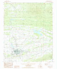 1983 Waldron1984 Print · USGSScott County and the town of Waldron are shown in the early 1980s as a hub of river valleys and timbered ridges. Genealogists and local historians can trace the paths of the KANSAS CITY SOUTHERN railroad or locate features like Lake Waldron and the Waldron City Airport.
 - 1983 Map of Boles, 1984 Print
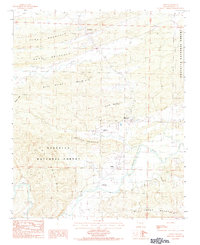 1983 Boles1984 Print · USGSThe Scott County highlands come into focus during the early eighties, where the Fourche La Fave River winds through the Ouachita National Forest. Researchers can trace old homesteads near The Pines and Needmore, or locate specialized landmarks like the Ratliff Landing Strip.
 - 1989 Map of Mena, 1991 Print
 1989 Mena1991 Print · USGSThe Ouachita and Kiamichi mountains define this borderland region in the late 1980s. Local historians can trace the Kansas City Southern RR corridor from Mena through settlements like Heavener and past the waters of Wister Lake.
End of results
Showing maps 1-3 of 3
Top cities near Waldron
Frequently asked questions
- What are the different types of historical maps available for Waldron?
- What is the oldest map of Waldron?
- Where can I purchase historical maps of Waldron for my home or office?
- Where can I download high-res historical maps of Waldron?
- Are there historical topographic maps available for Waldron?
- Is there historical aerial imagery available for Waldron?
- Where are historical maps of Waldron sourced from?