1940s Maps of Washington County, Arkansas
Explore 5 historic maps of Washington County from the 1940s. These maps offer a rare glimpse into what life looked like during the 1940s — showing old roads, neighborhoods, homes, and landmarks that have changed or disappeared over time.
Whether you're researching your family's past, planning a metal detecting trip, or studying how Washington County's landscape evolved across the 1940s, these high-resolution maps are a powerful tool for exploring the history of this region.
- Focus on a specific era: All maps on this page are from the 1940s, giving you a focused view of this time period.
- See what’s changed: Compare century-old streets, trails, and buildings to today's modern landscape using overlays and satellite layers.
- Research with precision: Use these maps for genealogy, historical research, land use analysis, or educational projects.
- View, download, or print: Maps are fully viewable online in high resolution, and can be downloaded or printed for your own records.
Start exploring Washington County's history through authentic maps from the 1940s. This is your window into the past.
Washington County, AR maps
(5)- 1943 Map of St. Paul, 1956 Print
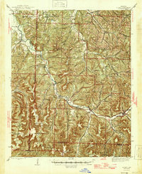
 1943 St. Paul1956 Print · USGSThe upper Ozark highlands of Madison County are captured here in the mid-1940s, showing a landscape of isolated mountain schools and river-valley settlements. Researchers can trace the heritage of rural communities through landmarks like St Paul, Hazel Valley Sch, and the Riverside Cem.5 unique versions available
 - 1945 Map of Harrison
 1945 Harrison1945 Print · USGSThe Ozark and Boston Mountains straddle the Missouri-Arkansas border during the mid-forties, showing a landscape of forest ridges and river valleys. Genealogists and historians can trace rail-connected towns like Monett and West Plains or early lake developments at Bull Shoals Res and Norfork Lake.
 - 1946 Map of St. Paul
 1946 St. Paul1946 Print · USGSMadison County's rugged Ozark interior is captured in the mid-forties, showing a landscape of remote hollows and mountain schools. Genealogists can trace family roots through sites like Liberty Cem, Delaney Creek Sch, and the community of St Paul.2 unique versions available
 - 1946 Map of Fort Smith
 1946 Fort Smith1946 Print · USGSThe Arkansas-Oklahoma borderlands appear here in the mid-forties, as new reservoirs began to transform the river valleys. Genealogists and historians can trace rail-served towns from Muskogee to Fort Smith and locate landmarks like Camp Chaffee.
 - 1949 Map of Harrison
 1949 Harrison1949 Print · USGSThe Ozark highlands of northern Arkansas and southern Missouri are shown just after the war, when the White River still followed its original course. Genealogists and historians can trace rail lines like the Missouri & Arkansas RR and locate rural hubs like Harrison, Eureka Springs, and Mountain Home.
End of results
Showing maps 1-5 of 5
Top cities of Washington County
- Fayetteville historical maps
- Farmington historical maps
- Prairie Grove historical maps
- Johnson historical maps
- Elm Springs historical maps
- West Fork historical maps
See more
Frequently asked questions
- What are the different types of historical maps available for Washington County?
- What is the oldest map of Washington County?
- Where can I purchase historical maps of Washington County for my home or office?
- Where can I download high-res historical maps of Washington County?
- Are there historical topographic maps available for Washington County?
- Is there historical aerial imagery available for Washington County?
- Where are historical maps of Washington County sourced from?