1990s Maps of Washington County, Arkansas
Explore 6 historic maps of Washington County from the 1990s. These maps offer a rare glimpse into what life looked like during the 1990s — showing old roads, neighborhoods, homes, and landmarks that have changed or disappeared over time.
Whether you're researching your family's past, planning a metal detecting trip, or studying how Washington County's landscape evolved across the 1990s, these high-resolution maps are a powerful tool for exploring the history of this region.
- Focus on a specific era: All maps on this page are from the 1990s, giving you a focused view of this time period.
- See what’s changed: Compare century-old streets, trails, and buildings to today's modern landscape using overlays and satellite layers.
- Research with precision: Use these maps for genealogy, historical research, land use analysis, or educational projects.
- View, download, or print: Maps are fully viewable online in high resolution, and can be downloaded or printed for your own records.
Start exploring Washington County's history through authentic maps from the 1990s. This is your window into the past.
Washington County, AR maps
(6)- 1992 Map of Russellville, 1993 Print
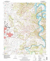
 1992 Russellville1993 Print · USGSCentral Arkansas in the early nineties shows a landscape defined by the Arkansas River valley and the surrounding national forests. Trace the development of river towns like Russellville and Dardanelle alongside landmarks such as Lake Dardanelle and Magazine Mtn.
 - 1994 Map of Springdale, 1998 Print
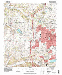 1994 Springdale1998 Print · USGSNorthwest Arkansas was undergoing rapid expansion in the 1990s as the urban centers of Springdale and Johnson began to merge. Researchers can trace family sites and old landmarks like Silent Grove Ch, Lake Elmdale, and the St Louis-San Francisco RR.
 - 1994 Map of Sonora, 1998 Print
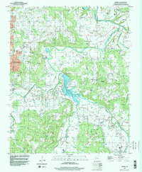
 1994 Sonora1998 Print · USGSThe White River valley east of Springdale comes into focus in the mid-1990s as suburban growth meets rural Arkansas tradition. Genealogists and local historians can trace legacy sites like Accident Sch, Phillips Cem, and the small settlement of Sonora.
 - 1994 Map of Elkins, 1998 Print
 1994 Elkins1998 Print · USGSEastern Washington County appears in the mid-1990s as a landscape of river forks and mountain ridges just before significant modern expansion. Family historians can locate several historic burial grounds like Birkhead Cem and Strain Cem, or trace the rural origins of Habberton and Baldwin.
 - 1994 Map of West Fork, 1998 Print
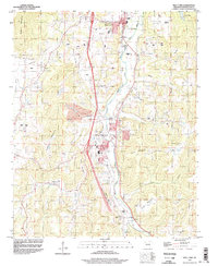 1994 West Fork1998 Print · USGSWest Fork and Greenland are seen here during a decade of transition in the mid-1990s as major highway construction began to reshape the river valley. Researchers can trace family history through several burial grounds and rural landmarks like Boone Cem, Woolsey Ch, and Pitkin Corner.2 unique versions available
 - 1995 Map of Fayetteville, 1998 Print
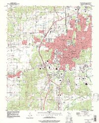 1995 Fayetteville1998 Print · USGSFayetteville and its mountainous fringes are captured in the mid-1990s as the city expanded around its historic landmarks and university core. Genealogists and researchers can trace local roots at the Confederate Cem, Mt Zion Ch, or through old rail connections at Fayette Junction.
End of results
Showing maps 1-6 of 6
Top cities of Washington County
- Fayetteville historical maps
- Farmington historical maps
- Prairie Grove historical maps
- Johnson historical maps
- Elm Springs historical maps
- West Fork historical maps
See more
Frequently asked questions
- What are the different types of historical maps available for Washington County?
- What is the oldest map of Washington County?
- Where can I purchase historical maps of Washington County for my home or office?
- Where can I download high-res historical maps of Washington County?
- Are there historical topographic maps available for Washington County?
- Is there historical aerial imagery available for Washington County?
- Where are historical maps of Washington County sourced from?