1960s Maps of Augusta, Arkansas
Explore 2 historic maps of Augusta from the 1960s. These maps offer a rare glimpse into what life looked like during the 1960s — showing old roads, neighborhoods, homes, and landmarks that have changed or disappeared over time.
Whether you're researching your family's past, planning a metal detecting trip, or studying how Augusta's landscape evolved across the 1960s, these high-resolution maps are a powerful tool for exploring the history of this region.
- Focus on a specific era: All maps on this page are from the 1960s, giving you a focused view of this time period.
- See what’s changed: Compare century-old streets, trails, and buildings to today's modern landscape using overlays and satellite layers.
- Research with precision: Use these maps for genealogy, historical research, land use analysis, or educational projects.
- View, download, or print: Maps are fully viewable online in high resolution, and can be downloaded or printed for your own records.
Start exploring Augusta's history through authentic maps from the 1960s. This is your window into the past.
Augusta, AR maps
(2)- 1968 Map of Augusta, 1969 Print
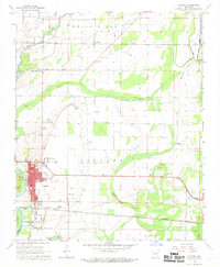 1968 Augusta1969 Print · USGSWoodruff County, Arkansas, appears in the late sixties as a thriving river-and-rail landscape centered on the historic seat of Augusta. Genealogists and local historians can trace family sites at Mt Olive Cem, Union, and the Carver Sch during this era of regional growth.2 unique versions available
 - 1968 Map of Augusta SW, 1970 Print
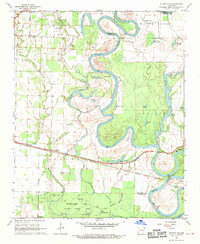 1968 Augusta SW1970 Print · USGSThe White River bottomlands in the late sixties reveal a landscape of winding oxbows and rural rail stops. Trace the old Missouri Pacific line through Rio Vista and Worden or locate family landmarks like Smith Cem.4 unique versions available
End of results
Showing maps 1-2 of 2
Top cities near Augusta
- Bald Knob historical maps
- McCrory historical maps
- Bradford historical maps
- Patterson historical maps
- Russell historical maps
- Tupelo historical maps
See more
Top neighborhoods of Augusta
Frequently asked questions
- What are the different types of historical maps available for Augusta?
- What is the oldest map of Augusta?
- Where can I purchase historical maps of Augusta for my home or office?
- Where can I download high-res historical maps of Augusta?
- Are there historical topographic maps available for Augusta?
- Is there historical aerial imagery available for Augusta?
- Where are historical maps of Augusta sourced from?