Old Maps of Hayward, California for Hiking & Exploration
Hike through history with 69 historic maps of Hayward. Explore old trails, ghost towns, and forgotten backroads — perfect for outdoor adventurers and local explorers.
- Rediscover forgotten places: Map out old mining camps, roads, and footpaths that no longer exist on modern maps.
- Layer with modern tools: Combine with LiDAR or satellite views to plan hikes through historical terrain.
- Made for exploration: Popular among hikers, overlanders, and local history lovers.
Use these maps to find adventure and explore the hidden past of Hayward.
Hayward, CA maps
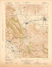
(69)- 1899 Map of Haywards
 1899 Haywards1899 Print · USGSThe East Bay shoreline at the end of the century was a landscape of industrial salt works and vital maritime landings. Genealogists and historians can trace the early rail stops at Haywards Sta. or locate family trade hubs at Mulford Landing and Jarvis Landing.5 unique versions available
 - 1906 Map of Pleasanton
 1906 Pleasanton1906 Print · USGSThe Livermore and Amador Valleys are captured here at the turn of the century as they transitioned from ranch lands to thriving rail hubs. Genealogists and historians can trace family locations near Mission San Jose, the old Dougherty Post Office, and the junction at Niles.5 unique versions available
 - 1915 Map of Haywards
 1915 Haywards1915 Print · USGSThe East Bay shoreline and inland foothills are shown here in the mid-1910s during a height of coastal industry. Genealogists and historians can trace old shipping points like Mulford Landing, early salt operations at Union City Salt Works, and the rail lines of the Western Pacific.4 unique versions available
 - 1941 Map of Pleasanton
 1941 Pleasanton1941 Print · USGSThe Livermore Valley and East Bay hills are captured here in the early 1940s, showing a world of cattle ranchos and railroad towns. You can trace early landmarks like the Mission San Jose de Guadalupe, the Livermore Airport, and several rural one-room schoolhouses like Antone Sch.
 - 1942 Map of Hayward
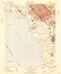
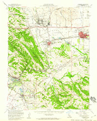
 1942 Hayward1942 Print · USGSThe East Bay shoreline and inland foothills come alive in the early 1940s as industry and infrastructure reshape the landscape. Researchers can trace the original footprints of Russell City and Mt Eden or locate the historic Oakland Speedway and Fairmont Hospital.
 - 1943 Map of Pleasanton
 1943 Pleasanton1943 Print · USGSThe Livermore and Amador Valleys are captured during the early 1940s, showing a landscape of ranching, railroads, and early institutional development. Genealogists and historians can locate old schools like Stonybrook Sch and landmarks such as Mission San Jose de Guadalupe.
 - 1947 Map of San Francisco, 1948 Print
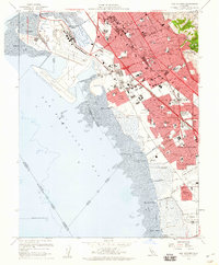
 1947 San Francisco1948 Print · USGSThe Bay Area in the late 1940s reveals a region transitioning from wartime intensity to post-war suburban growth. Trace the historic rail lines of the Southern Pacific RR or locate early military footprints at Fort Funston and Moffett Field.
 - 1947 Map of San Jose, 1948 Print
 1947 San Jose1948 Print · USGSNorthern California's heartland is captured here just after the war, showing the rapid growth of the Santa Clara and Central Valleys. Researchers can trace the legacy of rail and water at Castle Air Force Base, Stockton, and the Hetch Hetchy Aqueduct.
 - 1947 Map of San Leandro, 1956 Print
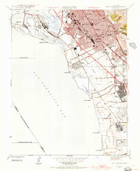 1947 San Leandro1956 Print · USGSThe East Bay shoreline in the late 1940s shows a fascinating mix of industrial salt production and rapid suburban development. Researchers can trace early aviation at the Oakland Municipal Airport or locate community anchors like San Lorenzo Village and the Oakland Speedway.
 - 1947 Map of Hayward, 1957 Print
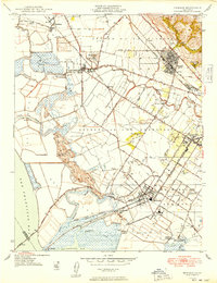
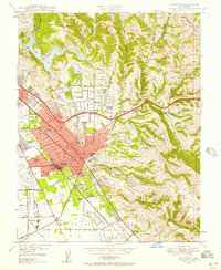 1947 Hayward1957 Print · USGSThe East Bay's post-war suburban transformation is evident in this mid-century view of the Hayward area. Genealogists and local historians can trace legacy sites like the Mt Eden Sta, the Oakland Speedway, and the Holy Sepulchre Cemetery.
 - 1947 Map of Newark, 1958 Print
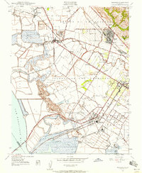 1947 Newark1958 Print · USGSThe industrial shoreline and agricultural plains of the East Bay are captured here just after the war. Local historians can trace early landings like Jarvis Landing and family landmarks such as Patterson Ranch and the Masonic Home.
 - 1948 Map of San Leandro
 1948 San Leandro1948 Print · USGSPost-war East Bay growth is on full display in this late 1940s survey of the shoreline. Genealogists and historians can trace the emergence of San Lorenzo Village or locate local landmarks like the Oakland Speedway, Powder Works, and the Naval Chapel.
 - 1948 Map of Redwood Point
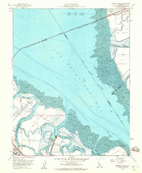
 1948 Redwood Point1948 Print · USGSThe San Mateo County shoreline in the late 1940s was a landscape of tidal marshes and industrial salt production. Trace the early layout of City Harbor and San Carlos Airport alongside landmarks like Oradio Sta KNBC.
 - 1948 Map of Newark
 1948 Newark1948 Print · USGSCoastal Alameda County is captured here in the late 1940s, showing a landscape defined by salt refineries and historic ranching tracts. Researchers can trace the industrial roots of Alvarado and Newark or locate family-history sites like the Masonic Home and Cypress Cem.
 - 1948 Map of San Francisco, 1951 Print
 1948 San Francisco1951 Print · USGSThe Bay Area in the late 1940s reveals a landscape defined by rapid post-war growth and a heavy military presence at the Golden Gate. Trace the development of early trans-bay infrastructure like the Oakland-Bay Bridge and historic coastal defense sites such as Fort Funston and Alcatraz Island.
 - 1950 Map of Hayward
 1950 Hayward1950 Print · USGSHayward and the East Bay hills are captured during the postwar building boom. Genealogists and local historians can trace old family sites and institutions like the Holy Sepulchre Cemetery, Mt Eden, and the historic Oakland Speedway.
 - 1953 Map of Dublin, 1955 Print
 1953 Dublin1955 Print · USGSThe Amador and San Ramon Valleys are captured here during the post-war era, as military installations and suburban pockets began to transform the ranchlands. Local historians can trace the foundations of Parks Air Force Base, the Old Hearst Ranch, and the early layout of Pleasanton.2 unique versions available
 - 1953 Map of Niles, 1955 Print
 1953 Niles1955 Print · USGSCoastal foothills and rail towns define this East Bay landscape in the early fifties, before the surge of suburban development. Researchers can trace the layout of Mission San Jose, locate the Centerville Airport, and find early landmarks like the Water Temple or Ohlones Cemetery.
 - 1953 Map of Livermore, 1960 Print
 1953 Livermore1960 Print · USGSThe East Bay valleys are shown during a period of significant growth and military activity in the early fifties. Researchers can trace historic family locations at Mission San Jose and local landmarks like the Water Temple or the Old Hearst Ranch.
 - 1955 Map of San Francisco
 1955 San Francisco1955 Print · USGSThe San Francisco Bay Area and central coast are captured during the postwar boom as suburbs and infrastructure expanded rapidly. Trace the development of local communities and military installations like the Presidio and Fort Mason, or follow the Southern Pacific rail lines.
 - 1956 Map of San Jose
 1956 San Jose1956 Print · USGSCentral California in the mid-fifties reveals the transition from sprawling orchards to growing urban hubs like San Jose and Stockton. Genealogists and historians can trace the rail-era landscape of the Mother Lode through Chinese Camp and Tuttletown, or follow the water through the Joaquin River and Calaveras Reservoir.
 - 1956 Map of San Francisco
 1956 San Francisco1956 Print · USGSThe San Francisco Bay Area is captured in the mid-fifties, showing a landscape of rapid post-war growth and massive military installations. Researchers can trace the sprawling rail lines of the Southern Pacific and locate historic sites like Stanford University or the Hunters Point Naval Shipyard.4 unique versions available
 - 1957 Map of San Francisco
 1957 San Francisco1957 Print · USGSThe Bay Area in the mid-fifties reveals a rapidly growing metropolitan landscape connected by its iconic spans and rail networks. Researchers can trace the layout of military sites like the Presidio and the extent of the Southern Pacific and Western Pacific railroads.
 - 1959 Map of Redwood Point, 1960 Print
 1959 Redwood Point1960 Print · USGSThe southern San Francisco Bay shoreline is defined by industrial salt works and complex slough systems in the late fifties. Trace the maritime history of the Port of Redwood City and the early footprints of the Belmont Salt Evaporators.7 unique versions available
 - 1959 Map of San Leandro, 1960 Print
 1959 San Leandro1960 Print · USGSThe East Bay shoreline in the late fifties shows the post-war transition from landings and marshes to a dense suburban corridor. Genealogists and historians can trace numerous neighborhood schools and landmarks like Russell City, Lorenzo Sta, and the Oakland Naval Air Station.4 unique versions available
Showing maps 1-25 of 69
Top cities near Hayward
- San Jose historical maps
- San Francisco historical maps
- Oakland historical maps
- Fremont historical maps
- Sunnyvale historical maps
- Santa Clara historical maps
See more
Top neighborhoods of Hayward
- Halvern historical maps
- Carpenter historical maps
- Sorenson historical maps
- Russell City historical maps
- Baumberg historical maps
Frequently asked questions
- What are the different types of historical maps available for Hayward?
- What is the oldest map of Hayward?
- Where can I purchase historical maps of Hayward for my home or office?
- Where can I download high-res historical maps of Hayward?
- Are there historical topographic maps available for Hayward?
- Is there historical aerial imagery available for Hayward?
- Where are historical maps of Hayward sourced from?