1990s Maps of Hayward, California
Explore 5 historic maps of Hayward from the 1990s. These maps offer a rare glimpse into what life looked like during the 1990s — showing old roads, neighborhoods, homes, and landmarks that have changed or disappeared over time.
Whether you're researching your family's past, planning a metal detecting trip, or studying how Hayward's landscape evolved across the 1990s, these high-resolution maps are a powerful tool for exploring the history of this region.
- Focus on a specific era: All maps on this page are from the 1990s, giving you a focused view of this time period.
- See what’s changed: Compare century-old streets, trails, and buildings to today's modern landscape using overlays and satellite layers.
- Research with precision: Use these maps for genealogy, historical research, land use analysis, or educational projects.
- View, download, or print: Maps are fully viewable online in high resolution, and can be downloaded or printed for your own records.
Start exploring Hayward's history through authentic maps from the 1990s. This is your window into the past.
Hayward, CA maps
(5)- 1993 Map of San Leandro, 1997 Print
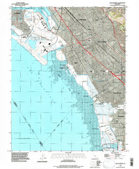 1993 San Leandro1997 Print · USGSThe East Bay shoreline comes alive in the early nineties, showcasing the expansion of Oakland and San Leandro. Trace the legacy of coastal industry through Salt Evaporators and historical sites like Roberts Landing and Russell City.
 - 1993 Map of Hayward, 1997 Print
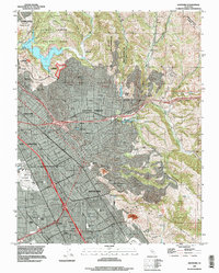 1993 Hayward1997 Print · USGSHayward and the East Bay hills are documented here in the 1990s as the suburban and academic landscape fully matured. Genealogists can trace family sites at Holy Sepulchre Cemetery or Mt Eden Cemetery, while local historians can locate the old Mt Eden Station.
 - 1993 Map of Newark, 1997 Print
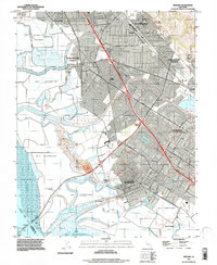 1993 Newark1997 Print · USGSThe East Bay shoreline and salt ponds are captured in the early nineties as suburban expansion met industrial heritage. Genealogists can trace family roots in Alvarado and Jarvis Landing or locate sites near Patterson Ranch.
 - 1993 Map of Redwood Point, 1997 Print
 1993 Redwood Point1997 Print · USGSThe South Bay shoreline comes into focus in the early nineties as industrial salt production meets suburban expansion. Trace the maritime history of the Port of Redwood City and the vast marshlands of Bair Island and Greco Island.
 - 1997 Map of Newark, 1999 Print
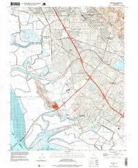 1997 Newark1999 Print · USGSThe East Bay shoreline in the late nineties shows a landscape defined by industrial salt production and rapid suburban growth. Trace local history through landmarks like Patterson Ranch, old rail sidings at Hall Station, and the historic districts of Alvarado and Decoto.
End of results
Showing maps 1-5 of 5
Top cities near Hayward
- San Jose historical maps
- San Francisco historical maps
- Oakland historical maps
- Fremont historical maps
- Sunnyvale historical maps
- Santa Clara historical maps
See more
Top neighborhoods of Hayward
- Halvern historical maps
- Carpenter historical maps
- Sorenson historical maps
- Russell City historical maps
- Baumberg historical maps
Frequently asked questions
- What are the different types of historical maps available for Hayward?
- What is the oldest map of Hayward?
- Where can I purchase historical maps of Hayward for my home or office?
- Where can I download high-res historical maps of Hayward?
- Are there historical topographic maps available for Hayward?
- Is there historical aerial imagery available for Hayward?
- Where are historical maps of Hayward sourced from?