1900s (20th Century) Maps of Cherokee, California
Explore 9 historic maps of Cherokee from the 1900s (20th Century). These maps offer a rare glimpse into what life looked like during the 1900s — showing old roads, neighborhoods, homes, and landmarks that have changed or disappeared over time.
Whether you're researching your family's past, planning a metal detecting trip, or studying how Cherokee's landscape evolved across the 1900s, these high-resolution maps are a powerful tool for exploring the history of this region.
- Focus on a specific era: All maps on this page are from the 1900s, giving you a focused view of this time period.
- See what’s changed: Compare century-old streets, trails, and buildings to today's modern landscape using overlays and satellite layers.
- Research with precision: Use these maps for genealogy, historical research, land use analysis, or educational projects.
- View, download, or print: Maps are fully viewable online in high resolution, and can be downloaded or printed for your own records.
Start exploring Cherokee's history through authentic maps from the 1900s. This is your window into the past.
Cherokee, CA maps
(9)- 1942 Map of Oroville, 1958 Print
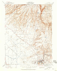 1942 Oroville1958 Print · USGSButte County foothills and the Sacramento Valley meet here in the early 1940s, just before the landscape was altered by mid-century water projects. Genealogists and historians can trace gold-era remnants at Cherokee, Oregon City, and the Bumble Bee Mines along the river.2 unique versions available
 - 1944 Map of Oroville
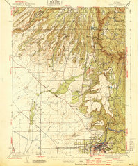 1944 Oroville1944 Print · USGSButte County at the height of the mid-century mining and rail era shows a landscape defined by the Feather River and the massive Table Mountains. Researchers can locate historic sites like Oregon City, the New Era Mine, and the Concow Sch.2 unique versions available
 - 1947 Map of Cherokee, 1961 Print
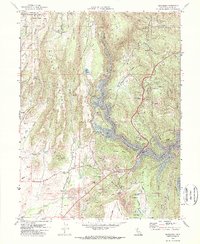
 1947 Cherokee1961 Print · USGSButte County's gold-mining landscape is documented here in the late 1940s, centered on the historic Cherokee hydraulic works. Researchers can trace family sites at Clear Creek Cemetery, the Messilla Valley Sch, and the Yankee Hill PO.3 unique versions available
 - 1949 Map of Cherokee
 1949 Cherokee1949 Print · USGSThe gold-mining districts of Butte County are captured here in the late 1940s as industry and infrastructure reshaped the Feather River canyons. Genealogists and historians can trace family locations near Cherokee, Yankee Hill PO, and the Clear Creek Cemetery.2 unique versions available
 - 1958 Map of Chico, 1962 Print
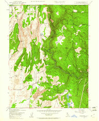
 1958 Chico1962 Print · USGSMid-century Northern California comes to life across the Central Valley and high Sierras as the postwar economy transformed the landscape. Trace the rail lines of the Southern Pacific RR, locate family roots near Chico Cem, or explore the early layout of Paradise and Beale Air Force Base.4 unique versions available
 - 1960 Map of Chico
 1960 Chico1960 Print · USGSThe Northern California high country and Sacramento Valley meet in this 1960s-era landscape of mining towns and river settlements. Trace the rail-and-water economy of the gold country through the Empire Mine, Beale Air Force Base, and the Western Pacific Railroad.
 - 1970 Map of Cherokee, 1973 Print
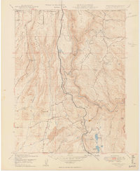
 1970 Cherokee1973 Print · USGSButte County’s transition from mining legacy to reservoir recreation is captured here as the new shoreline of Lake Oroville takes shape. Genealogy and local-history researchers can trace family landmarks like Messilla Valley Sch, the Cherokee Placer Mine, and Yankee Hill.2 unique versions available
 - 1980 Map of Chico
 1980 Chico1980 Print · USGSButte County and the Sierra foothills are shown here in the 1980s as the region's water and timber economies matured. Genealogists and researchers can trace old land grants like Rancho Capay or locate mountain mining sites and settlements such as Cherokee, Magalia, and the Big Bend Mine.2 unique versions available
 - 1994 Map of Cherokee, 1997 Print
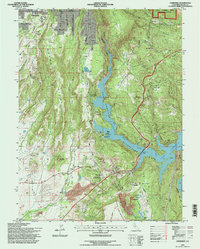 1994 Cherokee1997 Print · USGSButte County in the mid-1990s reveals a landscape shaped by gold-mining history and modern water management. Researchers can trace the massive Cherokee Placer Mines and locate local landmarks like Yankee Hill, Concow Sch, and the Clear Creek Cem.
End of results
Showing maps 1-9 of 9
Top cities near Cherokee
- Chico historical maps
- Oroville historical maps
- Durham historical maps
- Paradise historical maps
- Biggs historical maps
Frequently asked questions
- What are the different types of historical maps available for Cherokee?
- What is the oldest map of Cherokee?
- Where can I purchase historical maps of Cherokee for my home or office?
- Where can I download high-res historical maps of Cherokee?
- Are there historical topographic maps available for Cherokee?
- Is there historical aerial imagery available for Cherokee?
- Where are historical maps of Cherokee sourced from?