1950s Maps of Delevan, California
Explore 3 historic maps of Delevan from the 1950s. These maps offer a rare glimpse into what life looked like during the 1950s — showing old roads, neighborhoods, homes, and landmarks that have changed or disappeared over time.
Whether you're researching your family's past, planning a metal detecting trip, or studying how Delevan's landscape evolved across the 1950s, these high-resolution maps are a powerful tool for exploring the history of this region.
- Focus on a specific era: All maps on this page are from the 1950s, giving you a focused view of this time period.
- See what’s changed: Compare century-old streets, trails, and buildings to today's modern landscape using overlays and satellite layers.
- Research with precision: Use these maps for genealogy, historical research, land use analysis, or educational projects.
- View, download, or print: Maps are fully viewable online in high resolution, and can be downloaded or printed for your own records.
Start exploring Delevan's history through authentic maps from the 1950s. This is your window into the past.
Delevan, CA maps
(3)- 1952 Map of Maxwell, 1953 Print
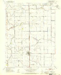 1952 Maxwell1953 Print · USGSAgricultural life in the early fifties revolves around the railroad towns of the Sacramento Valley. Genealogists and local historians can trace the foundations of Maxwell and Delevan near the Union Church and the Maxwell Cemetery.3 unique versions available
 - 1952 Map of Maxwell, 1958 Print
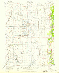 1952 Maxwell1958 Print · USGSThe Sacramento Valley comes alive in this mid-century survey of the Maxwell and Princeton areas, showcasing a landscape of river bends and rail sidings. Genealogists can trace family roots through several rural schools like Liberty Sch and Codora Sch, or locate the historic Cachil Dehe Rancheria.2 unique versions available
 - 1957 Map of Ukiah, 1966 Print
 1957 Ukiah1966 Print · USGSNorthern California's diverse terrain comes into focus in the mid-1950s, from the rugged timberlands of the Jackson State Forest to the productive Sacramento Valley. Genealogists and historians can trace the rail lines of the Northwestern Pacific or locate early valley settlements like Arbuckle and Paskenta.3 unique versions available
End of results
Showing maps 1-3 of 3
Top cities near Delevan
- Willows historical maps
- Colusa historical maps
- Williams historical maps
- Maxwell historical maps
- Butte City historical maps
Frequently asked questions
- What are the different types of historical maps available for Delevan?
- What is the oldest map of Delevan?
- Where can I purchase historical maps of Delevan for my home or office?
- Where can I download high-res historical maps of Delevan?
- Are there historical topographic maps available for Delevan?
- Is there historical aerial imagery available for Delevan?
- Where are historical maps of Delevan sourced from?