Old Maps of Sites, California for Metal Detecting
Plan your next treasure hunt with 12 historic maps of Sites. Find old homesites, ghost towns, trails, and gathering spots that may be lost to time — perfect for identifying promising metal detecting locations.
- Locate forgotten sites: Uncover places like long-lost settlements, abandoned rail lines, or gathering spots.
- Plan better hunts: Use map overlays combined with LiDAR or satellite views to narrow in on historically rich areas.
- Made for detectorists: Thousands of hobbyists use these maps to discover relics, coins, and hidden history.
Use these historic maps to boost your research and find new opportunities beneath the surface of Sites.
Sites, CA maps
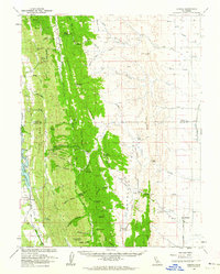
(12)- 1904 Map of Sites, 1957 Print
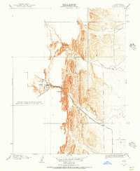 1904 Sites1957 Print · USGSColusa County at the turn of the century shows a landscape shaped by early quarrying and the arrival of the rails. Genealogists and historians can trace the townsite of Sites, the local Cemetery, and the path of the Colusa and Lake railroad.2 unique versions available
 - 1917 Map of Sites
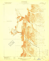 1917 Sites1917 Print · USGSColusa County at the turn of the century was a landscape of sandstone extraction and early rail development centered on Antelope Valley. Researchers can trace the industrial footprint of the Colusa Quarry and the Colusa and Lake rail line that served the village of Sites.3 unique versions available
 - 1943 Map of Lodoga
 1943 Lodoga1943 Print · USGSThe foothills of the Sacramento Valley were undergoing a transformation during the 1940s as irrigation reached the plains. Researchers can locate the settlement of Sites, the Black Mtn Sch, and early fruit production at Mills Orchards.2 unique versions available
 - 1957 Map of Ukiah, 1966 Print
 1957 Ukiah1966 Print · USGSNorthern California's diverse terrain comes into focus in the mid-1950s, from the rugged timberlands of the Jackson State Forest to the productive Sacramento Valley. Genealogists and historians can trace the rail lines of the Northwestern Pacific or locate early valley settlements like Arbuckle and Paskenta.3 unique versions available
 - 1958 Map of Sites, 1960 Print
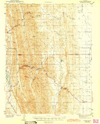
 1958 Sites1960 Print · USGSColusa County ranching and rural life are preserved in this mid-century survey of the Antelope Valley. Researchers can trace family-named routes and landmarks like Huffmaster Road, the settlement of Sites, and the Swifts Stone Corral.3 unique versions available
 - 1960 Map of Ukiah
 1960 Ukiah1960 Print · USGSNorthern California during the late fifties reveals a landscape of deep timber forests and valley agriculture before modern expansion. Trace the historic rail lines of the California Western RR and the Northwestern Pacific RR through settlements like Fort Bragg and Ukiah.2 unique versions available
 - 1960 Map of Lodoga, 1962 Print
 1960 Lodoga1962 Print · USGSLodoga and the rugged ridges of the Colusa and Glenn county border are captured here in the early sixties. Genealogists and local historians can locate early rural landmarks like Little Stony Sch, Mills Orchards, and the historic Swifts Stone Corral.2 unique versions available
 - 1994 Map of Lakeport
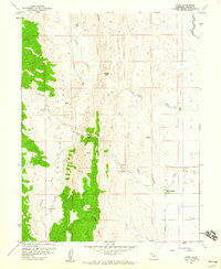
 1994 Lakeport1994 Print · USGSCoastal mountains meet the fertile Sacramento Valley in the 1990s, where the waters of Clear Lake define the western landscape. Researchers can trace the industrial footprint of the Sulphur Bank Mine, follow the Southern Pacific RR tracks, or locate old settlements like Fouts Springs and Lodoga.
 - 2012 Map of Sites, 2012 Print
 2012 Sites2012 Print · USGSCovers Sites, including Colusa County, United States, and other nearby areas
 - 2015 Map of Sites, 2015 Print
 2015 Sites2015 Print · USGSCovers Sites, including Colusa County, United States, and other nearby areas
 - 2018 Map of Sites, 2018 Print
 2018 Sites2018 Print · USGSCovers Sites, including Colusa County, United States, and other nearby areas
 - 2021 Map of Sites, 2021 Print
 2021 Sites2021 Print · USGSThe rural landscapes of western Colusa County are mapped here in the modern era, centering on the historic ranching community of Sites. Researchers can trace local landmarks like Sites Cem and Mills Orchards alongside the Tehama Colusa Canal.
End of results
Showing maps 1-12 of 12
Top cities near Sites
Frequently asked questions
- What are the different types of historical maps available for Sites?
- What is the oldest map of Sites?
- Where can I purchase historical maps of Sites for my home or office?
- Where can I download high-res historical maps of Sites?
- Are there historical topographic maps available for Sites?
- Is there historical aerial imagery available for Sites?
- Where are historical maps of Sites sourced from?