1940s Maps of Antioch, California
Explore 5 historic maps of Antioch from the 1940s. These maps offer a rare glimpse into what life looked like during the 1940s — showing old roads, neighborhoods, homes, and landmarks that have changed or disappeared over time.
Whether you're researching your family's past, planning a metal detecting trip, or studying how Antioch's landscape evolved across the 1940s, these high-resolution maps are a powerful tool for exploring the history of this region.
- Focus on a specific era: All maps on this page are from the 1940s, giving you a focused view of this time period.
- See what’s changed: Compare century-old streets, trails, and buildings to today's modern landscape using overlays and satellite layers.
- Research with precision: Use these maps for genealogy, historical research, land use analysis, or educational projects.
- View, download, or print: Maps are fully viewable online in high resolution, and can be downloaded or printed for your own records.
Start exploring Antioch's history through authentic maps from the 1940s. This is your window into the past.
Antioch, CA maps
(5)- 1940 Map of Byron, 1943 Print
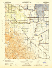 1940 Byron1943 Print · USGSThe California Delta meets the coastal hills during the early 1940s, showing a transition from the orchards of Brentwood to the intricate waterways of the islands. Researchers can trace historic schools like Iron House Sch, rail stops at Knighten Sta, and the famous Byron Hot Springs.
 - 1943 Map of Mt. Diablo
 1943 Mt. Diablo1943 Print · USGSThe Mt. Diablo foothills and San Ramon Valley are captured here during the early 1940s, showcasing a landscape of cattle ranches and remote schoolhouses. Genealogists and local historians can locate early landmarks like Blackhawk Ranch, Cowell, and the Morgan Territory Sch.
 - 1947 Map of Sacramento, 1948 Print
 1947 Sacramento1948 Print · USGSThe Sacramento Valley meets the high Sierra during a period of post-war expansion. Trace the historic river delta islands like Grand Island or locate early airfield footprints at McClellan Air Force Base and Mather Air Force Base.2 unique versions available
 - 1947 Map of San Jose, 1948 Print
 1947 San Jose1948 Print · USGSNorthern California's heartland is captured here just after the war, showing the rapid growth of the Santa Clara and Central Valleys. Researchers can trace the legacy of rail and water at Castle Air Force Base, Stockton, and the Hetch Hetchy Aqueduct.
 - 1948 Map of Sacramento, 1951 Print
 1948 Sacramento1951 Print · USGSPost-war Northern California comes alive in this regional survey, capturing the era of expansion between the Central Valley and the High Sierra. Researchers can trace the rail networks of the Central California Traction and Sacramento Northern RR or locate landmarks like the State Capitol and University of California Davis.
End of results
Showing maps 1-5 of 5
Top cities near Antioch
- Concord historical maps
- Fairfield historical maps
- San Ramon historical maps
- Pittsburg historical maps
- Walnut Creek historical maps
- Brentwood historical maps
See more
Top neighborhoods of Antioch
Frequently asked questions
- What are the different types of historical maps available for Antioch?
- What is the oldest map of Antioch?
- Where can I purchase historical maps of Antioch for my home or office?
- Where can I download high-res historical maps of Antioch?
- Are there historical topographic maps available for Antioch?
- Is there historical aerial imagery available for Antioch?
- Where are historical maps of Antioch sourced from?