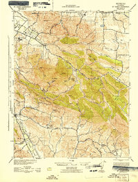
1943 Map of Mt. Diablo
USGS Topo · Published 1943About this map
Mt Diablo and its surrounding peaks dominate this 1943 landscape, providing a detailed look at Contra Costa County during the early war years. The area is defined by a series of significant canyons and valleys, including Marsh Creek and Amador Valley, which shaped the early road networks like Kirker Pass Road. Local education and social centers are well-documented through rural schoolhouses such as Morgan Territory Sch, Liberty Sch, and Tassajara Sch, many of which served dispersed ranching families. The Southern Pacific railroad corridor tracks through the western and northern edges, connecting the industrial settlement of Cowell and the agricultural hub of Danville. This survey, revised using 1937 aerial photography from the 91st Observation Squadron, captures the transition from cattle ranching at Blackhawk Ranch to the early development of San Ramon and Clayton.
Find a feature on this map
52 named features on this map. Tap any name to fly to it.
Don’t see what you’re looking for? This feature index may not catch every label — zoom into the map to look around manually.
Map Details
Editions of this 1943 Mt. Diablo Map
This is the sole edition of this map. No revisions or reprints were ever made.
Other maps of this area

1896 · Carquinez Strait
USGS Topo · 1:62,500

1896 · Mt. Diablo
USGS Topo · 1:62,500

1897 · Concord
USGS Topo · 1:62,500

1898 · Karquines
USGS Topo · 1:62,500

1898 · Mt. Diablo
USGS Topo · 1:62,500

1899 · Haywards
USGS Topo · 1:62,500

1901 · Karquines
USGS Topo · 1:62,500

1902 · Napa
USGS Topo · 1:125,000

1906 · Pleasanton
USGS Topo · 1:62,500

1907 · Tesla
USGS Topo · 1:62,500