Old Maps of Discovery Bay, California for Metal Detecting
Plan your next treasure hunt with 14 historic maps of Discovery Bay. Find old homesites, ghost towns, trails, and gathering spots that may be lost to time — perfect for identifying promising metal detecting locations.
- Locate forgotten sites: Uncover places like long-lost settlements, abandoned rail lines, or gathering spots.
- Plan better hunts: Use map overlays combined with LiDAR or satellite views to narrow in on historically rich areas.
- Made for detectorists: Thousands of hobbyists use these maps to discover relics, coins, and hidden history.
Use these historic maps to boost your research and find new opportunities beneath the surface of Discovery Bay.
Discovery Bay, CA maps
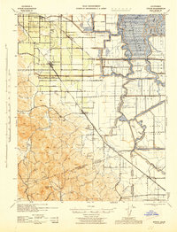
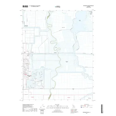
(14)- 1913 Map of Woodward Island
 1913 Woodward Island1913 Print · USGSThe reclaimed islands of the California Delta appear in this pre-war survey as a sophisticated network of levees and rail. Trace early commercial hubs like the Cannery at Woodward and the rural Middle River Moorland P O.
 - 1916 Map of Byron
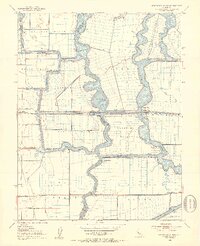
 1916 Byron1916 Print · USGSIn the early twentieth century, the Contra Costa and San Joaquin borderlands were a landscape of reclaimed delta tracts and rising hill country. Researchers can trace early railroad alignments and rural life at Byron Hot Sprs, the Bethany Ferry, and the Vasco School.3 unique versions available
 - 1940 Map of Byron, 1943 Print
 1940 Byron1943 Print · USGSThe California Delta meets the coastal hills during the early 1940s, showing a transition from the orchards of Brentwood to the intricate waterways of the islands. Researchers can trace historic schools like Iron House Sch, rail stops at Knighten Sta, and the famous Byron Hot Springs.
 - 1947 Map of San Jose, 1948 Print
 1947 San Jose1948 Print · USGSNorthern California's heartland is captured here just after the war, showing the rapid growth of the Santa Clara and Central Valleys. Researchers can trace the legacy of rail and water at Castle Air Force Base, Stockton, and the Hetch Hetchy Aqueduct.
 - 1952 Map of Woodward Island, 1953 Print
 1952 Woodward Island1953 Print · USGSThe California Delta at the start of the fifties was a maze of reclaimed tracts and vital water engineering projects. Trace the rail-and-water economy through the Mokelumne Aqueduct and small stops like Bixler and Orwood along the Atchison Topeka and Santa Fe line.4 unique versions available
 - 1956 Map of San Jose
 1956 San Jose1956 Print · USGSCentral California in the mid-fifties reveals the transition from sprawling orchards to growing urban hubs like San Jose and Stockton. Genealogists and historians can trace the rail-era landscape of the Mother Lode through Chinese Camp and Tuttletown, or follow the water through the Joaquin River and Calaveras Reservoir.
 - 1962 Map of San Jose
 1962 San Jose1962 Print · USGSCentral California in the early sixties showcases the expansion of the San Joaquin and Santa Clara valleys. Researchers can trace the rail-to-road transition along the Southern Pacific RR or locate landmarks like Castle USAF Base and Loma Prieta.4 unique versions available
 - 1966 Map of San Jose
 1966 San Jose1966 Print · USGSCentral California in the mid-1960s reveals a landscape of massive irrigation projects and expanding Cold War military footprints. Researchers can trace the rail-and-river network of the San Joaquin Valley or locate specialized sites like Castle Air Force Base and the Sharp General Depot (Military).
 - 1978 Map of Woodward Island, 1979 Print
 1978 Woodward Island1979 Print · USGSThe California Delta in the late seventies is shown as a complex grid of reclaimed islands and sloughs. Trace the path of the Woodward Island Ferry and old rail stops like Orwood and Werner along the Mokelumne Aqueduct.2 unique versions available
 - 1989 Map of Stockton
 1989 Stockton1989 Print · USGSDuring the late 1980s, the California Delta and San Joaquin Valley saw a massive convergence of water infrastructure and military logistics. Researchers can trace the sprawling Lawrence Livermore Laboratory (Univ of Calif) and Sharpe Army Depot alongside the complex waterways of Union Island and Victoria Island.2 unique versions available
 - 2012 Map of Woodward Island, 2012 Print
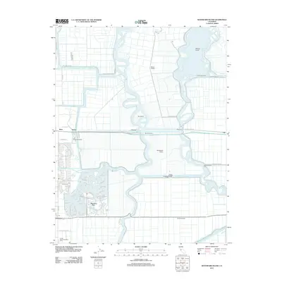 2012 Woodward Island2012 Print · USGSCovers Discovery Bay, including Oakley, Bixler, and other nearby areas
 - 2015 Map of Woodward Island, 2015 Print
 2015 Woodward Island2015 Print · USGSCovers Discovery Bay, including Oakley, Bixler, and other nearby areas
 - 2018 Map of Woodward Island, 2018 Print
 2018 Woodward Island2018 Print · USGSCovers Discovery Bay, including Oakley, Bixler, and other nearby areas
 - 2021 Map of Woodward Island, 2021 Print
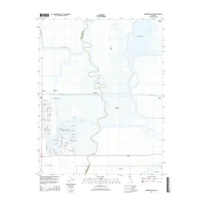
 2021 Woodward Island2021 Print · USGSThe Sacramento-San Joaquin River Delta comes alive in this contemporary view of its intricate waterways and reclaimed islands. Trace the residential canals of Discovery Bay and the industrial path of the Mokelumne Aqueduct past Orwood.
End of results
Showing maps 1-14 of 14
Top cities near Discovery Bay
- Stockton historical maps
- Antioch historical maps
- Tracy historical maps
- Livermore historical maps
- Pleasanton historical maps
- Lodi historical maps
See more
Frequently asked questions
- What are the different types of historical maps available for Discovery Bay?
- What is the oldest map of Discovery Bay?
- Where can I purchase historical maps of Discovery Bay for my home or office?
- Where can I download high-res historical maps of Discovery Bay?
- Are there historical topographic maps available for Discovery Bay?
- Is there historical aerial imagery available for Discovery Bay?
- Where are historical maps of Discovery Bay sourced from?