1950s Maps of Oakley, California
Explore 11 historic maps of Oakley from the 1950s. These maps offer a rare glimpse into what life looked like during the 1950s — showing old roads, neighborhoods, homes, and landmarks that have changed or disappeared over time.
Whether you're researching your family's past, planning a metal detecting trip, or studying how Oakley's landscape evolved across the 1950s, these high-resolution maps are a powerful tool for exploring the history of this region.
- Focus on a specific era: All maps on this page are from the 1950s, giving you a focused view of this time period.
- See what’s changed: Compare century-old streets, trails, and buildings to today's modern landscape using overlays and satellite layers.
- Research with precision: Use these maps for genealogy, historical research, land use analysis, or educational projects.
- View, download, or print: Maps are fully viewable online in high resolution, and can be downloaded or printed for your own records.
Start exploring Oakley's history through authentic maps from the 1950s. This is your window into the past.
Oakley, CA maps
(11)- 1951 Map of Antioch
 1951 Antioch1951 Print · USGSThe Sacramento Delta comes alive in the early fifties as industrial growth meets a complex world of sloughs and islands. Trace family ties to Birds Landing, the Grizzly Island Ferry, or the sprawling grounds of Camp Stoneman.
 - 1952 Map of Woodward Island, 1953 Print
 1952 Woodward Island1953 Print · USGSThe California Delta at the start of the fifties was a maze of reclaimed tracts and vital water engineering projects. Trace the rail-and-water economy through the Mokelumne Aqueduct and small stops like Bixler and Orwood along the Atchison Topeka and Santa Fe line.4 unique versions available
 - 1952 Map of Jersey Island, 1954 Print
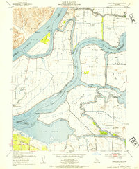 1952 Jersey Island1954 Print · USGSThe Sacramento-San Joaquin River Delta at mid-century is captured here as a sprawling network of leveed islands and tidal sloughs. Genealogists and historians can trace the early roads of Bethel Island or locate the Mayberry Slough Facility Military Reservation and the ferry crossing at Fishermans Cut.3 unique versions available
 - 1952 Map of Rio Vista, 1959 Print
 1952 Rio Vista1959 Print · USGSThe California Delta in the early fifties shows a vibrant network of river towns and island tracts defined by a complex levee system. Genealogists can locate family landmarks from Locke to Bethel Island, including rural anchors like the Beaver Union School and Howard Landing.2 unique versions available
 - 1953 Map of Antioch South, 1954 Print
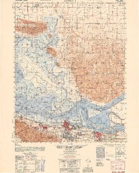
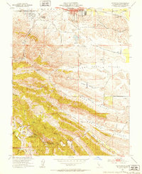 1953 Antioch South1954 Print · USGSContra Costa County at the start of the 1950s reveals a landscape where old mining towns were becoming memories as the suburbs of Antioch began to reach south. Genealogists and historians can trace the footprint of Somersville, locate Coal Mine Tunnels, and find the Morgan Territory Sch.9 unique versions available
 - 1953 Map of Antioch North, 1955 Print
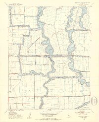
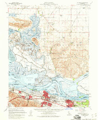
 1953 Antioch North1955 Print · USGSThe delta where the Sacramento and San Joaquin rivers meet shows a landscape of heavy industry and island agriculture in the 1950s. Genealogists and researchers can trace the rail corridors of the Southern Pacific or locate family sites like the Adelia Kimball School and Holy Cross Cem.4 unique versions available
 - 1953 Map of Pittsburg, 1960 Print
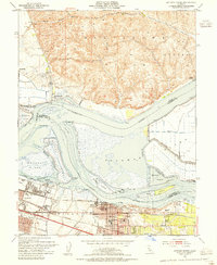
 1953 Pittsburg1960 Print · USGSThe Suisun Bay waterfront and the Delta's tidal marshes are captured here in the mid-fifties, showing the industrial growth of Contra Costa County. Genealogists and researchers can trace family-named locations like Hierlihy Ranch, local landmarks like Shilo Church, and the riverfront community of Collinsville.2 unique versions available
 - 1954 Map of Brentwood, 1955 Print
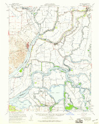
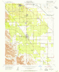 1954 Brentwood1955 Print · USGSIn the mid-fifties, this corner of Contra Costa County was a landscape of expanding orchards and vital rail corridors. Genealogists and local historians can trace the foundations of Brentwood and Oakley, locating the Point of Timber Cemetery and the John Marsh Historical Marker.5 unique versions available
 - 1956 Map of San Jose
 1956 San Jose1956 Print · USGSCentral California in the mid-fifties reveals the transition from sprawling orchards to growing urban hubs like San Jose and Stockton. Genealogists and historians can trace the rail-era landscape of the Mother Lode through Chinese Camp and Tuttletown, or follow the water through the Joaquin River and Calaveras Reservoir.
 - 1956 Map of Sacramento
 1956 Sacramento1956 Print · USGSMid-century California unfolds from the delta to the high Sierra, capturing a landscape of growing valley cities and burgeoning military airbases. Genealogists and historians can trace the rail lines and river towns from Woodland to Lodi, or explore the foothill settlements of Placerville and Jackson.2 unique versions available
 - 1957 Map of Sacramento, 1966 Print
 1957 Sacramento1966 Print · USGSIn the mid-twentieth century, the California heartland was a hub of river transport, rail lines, and military airbases. Genealogists and historians can trace the development of Gold Country towns like Angels Camp and Sonora or follow the path of the Southern Pacific RR through the growing suburbs of Sacramento.4 unique versions available
End of results
Showing maps 1-11 of 11
Top cities near Oakley
- Fairfield historical maps
- Antioch historical maps
- Tracy historical maps
- San Ramon historical maps
- Pittsburg historical maps
- Brentwood historical maps
See more
Top neighborhoods of Oakley
Frequently asked questions
- What are the different types of historical maps available for Oakley?
- What is the oldest map of Oakley?
- Where can I purchase historical maps of Oakley for my home or office?
- Where can I download high-res historical maps of Oakley?
- Are there historical topographic maps available for Oakley?
- Is there historical aerial imagery available for Oakley?
- Where are historical maps of Oakley sourced from?