Old Maps of Peak Eight, California for Academic Research
Study the evolution of Peak Eight with 14 high-resolution historic maps. Whether you're teaching, researching, or modeling changes in land use, these maps provide essential visual documentation of urban, environmental, and geographic change.
- Analyze long-term change: Track patterns in development, transportation, and natural features.
- Ideal for environmental or urban studies: Support academic projects with primary historical map data.
- Use in the classroom or lab: Educators and researchers rely on these maps to bring historical context to life.
These maps are a powerful tool for teaching, research, and visualizing how Peak Eight has changed over the decades.
Peak Eight, CA maps
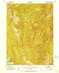
(14)- 1922 Map of Preston Peak
 1922 Preston Peak1922 Print · USGSThe California-Oregon borderlands are mapped here just before the era of modern highway expansion, showing a network of remote river bars and mountain ranches. Trace the locations of early outposts like Gasquet Adams Sta, the Cleopatra Mine, and Terwer School.5 unique versions available
 - 1945 Map of Ship Mountain
 1945 Ship Mountain1945 Print · USGSIn the mid-1940s, the remote ridges of Del Norte County were defined by a series of high-altitude lookouts and family ranches. Researchers can trace historic river access and mountain life through features like the Chrome Mine, Turwar School, and the Knapp Estate.
 - 1948 Map of Weed, 1950 Print
 1948 Weed1950 Print · USGSNorthern California and Southern Oregon are captured here during the post-war era, documenting the mountain-and-valley economies of the Klamath and Cascade ranges. Trace the legacy of local mining and timber at the King Solomon Mine, find old schools like Siskiyou County School, and follow the historic Southern Pacific RR route.2 unique versions available
 - 1950 Map of Weed
 1950 Weed1950 Print · USGSSiskiyou County and the surrounding Klamath mountains appear in the mid-century before extensive modern development. Genealogists and local historians can locate remote outposts like the Lee Brown Ranch and the specialized settlement of Darlingtonia.
 - 1952 Map of Ship Mountain, 1954 Print
 1952 Ship Mountain1954 Print · USGSThe Del Norte backcountry in the early fifties shows a remote landscape of forest lookouts and riverside ranching. Genealogists and historians can trace isolated family outposts like Wilson Ranch and Alma Ranch or locate early forest camps such as Marlow Camp.3 unique versions available
 - 1958 Map of Weed, 1963 Print
 1958 Weed1963 Print · USGSThe Northern California high country of the late fifties is defined by the towering presence of Mt Shasta and the logging railroads of the Siskiyou range. Genealogists and researchers can trace remote mining sites like the China Mine and mountain settlements such as Sawyers Bar and Seiad Valley.3 unique versions available
 - 1963 Map of Weed
 1963 Weed1963 Print · USGSNorthern California during the early 1960s shows a landscape of steep mountain ranges and river-fed valleys at the height of the timber era. Researchers can trace the routes of the McCloud River RR, locate remote sites like the Holiday Mine, or find ancestral markers at the Scott Valley Cem.
 - 1981 Map of Summit Valley, 1982 Print
 1981 Summit Valley1982 Print · USGSDel Norte County's backwoods are documented here in the early 1980s, showcasing the high-elevation terrain of the Six Rivers National Forest. Hikers and historians can trace the Summit Valley Trail to Doctor Rock or locate the Summit Valley Shelter and Cedar Camp Spring.
 - 1983 Map of Happy Camp, 1984 Print
 1983 Happy Camp1984 Print · USGSThe Northern California borderlands and the Klamath River corridor are documented here in the early eighties as a hub of mining and forestry. Researchers can trace historical extraction at the High Plateau Mine and Independence Mine or locate the remote riverside community of Scott Bar.
 - 1997 Map of Summit Valley, 2001 Print
 1997 Summit Valley2001 Print · USGSDel Norte County's high wilderness is surveyed here in the late nineties, showcasing the intersection of national forest and recreation lands. Trace the remote locations of the Summit Valley Lookout, the high point of Doctor Rock, and a local Quarry.
 - 2012 Map of Summit Valley, 2012 Print
 2012 Summit Valley2012 Print · USGSCovers Peak Eight, including Del Norte County, United States, and other nearby areas
 - 2015 Map of Summit Valley, 2015 Print
 2015 Summit Valley2015 Print · USGSCovers Peak Eight, including Del Norte County, United States, and other nearby areas
 - 2018 Map of Summit Valley, 2018 Print
 2018 Summit Valley2018 Print · USGSCovers Peak Eight, including Del Norte County, United States, and other nearby areas
 - 2022 Map of Summit Valley, 2022 Print
 2022 Summit Valley2022 Print · USGSWithin the Klamath Mountains in the early 2020s, this area shows the protected wilderness of the Six Rivers National Forest. Researchers can trace remote routes like Gasquet-Orleans past landmarks such as Doctor Rock and Summit Valley.
End of results
Showing maps 1-14 of 14
Frequently asked questions
- What are the different types of historical maps available for Peak Eight?
- What is the oldest map of Peak Eight?
- Where can I purchase historical maps of Peak Eight for my home or office?
- Where can I download high-res historical maps of Peak Eight?
- Are there historical topographic maps available for Peak Eight?
- Is there historical aerial imagery available for Peak Eight?
- Where are historical maps of Peak Eight sourced from?