1950s Maps of Dinkey Creek, California
Explore 2 historic maps of Dinkey Creek from the 1950s. These maps offer a rare glimpse into what life looked like during the 1950s — showing old roads, neighborhoods, homes, and landmarks that have changed or disappeared over time.
Whether you're researching your family's past, planning a metal detecting trip, or studying how Dinkey Creek's landscape evolved across the 1950s, these high-resolution maps are a powerful tool for exploring the history of this region.
- Focus on a specific era: All maps on this page are from the 1950s, giving you a focused view of this time period.
- See what’s changed: Compare century-old streets, trails, and buildings to today's modern landscape using overlays and satellite layers.
- Research with precision: Use these maps for genealogy, historical research, land use analysis, or educational projects.
- View, download, or print: Maps are fully viewable online in high resolution, and can be downloaded or printed for your own records.
Start exploring Dinkey Creek's history through authentic maps from the 1950s. This is your window into the past.
Dinkey Creek, CA maps
(2)- 1953 Map of Huntington Lake, 1955 Print
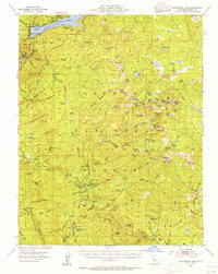 1953 Huntington Lake1955 Print · USGSThe Fresno County high country is shown in the early fifties as a hub of timber milling and mountain recreation. Researchers can locate remote logging outposts like Pine Logging Camp and Bretz Mill, or trace the trails around Dinkey Creek Ranger Sta and Mc Kinley Grove.4 unique versions available
 - 1957 Map of Mariposa, 1966 Print
 1957 Mariposa1966 Print · USGSThe High Sierra and Owens Valley appear in the mid-fifties, showing the intersection of conservation, hydroelectric power, and mountain industry. Genealogists and researchers can trace local landmarks like Yosemite Cemetery, the remote Kinsley Station, and the Pine Creek Mine.4 unique versions available
End of results
Showing maps 1-2 of 2
Frequently asked questions
- What are the different types of historical maps available for Dinkey Creek?
- What is the oldest map of Dinkey Creek?
- Where can I purchase historical maps of Dinkey Creek for my home or office?
- Where can I download high-res historical maps of Dinkey Creek?
- Are there historical topographic maps available for Dinkey Creek?
- Is there historical aerial imagery available for Dinkey Creek?
- Where are historical maps of Dinkey Creek sourced from?